 |
|
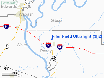
Location
& QuickFacts
|
FAA
Information Effective: |
2007-12-20 |
|
Airport
Identifier: |
3II2 |
|
Airport
Status: |
Operational |
|
Longitude/Latitude: |
087-55-10.1100W/38-12-46.1650N
-87.919475/38.212824 (Estimated) |
|
Elevation: |
445 ft / 135.64 m (Estimated) |
|
Land: |
0 acres |
|
From nearest
city: |
1 nautical miles NW of Griffin, IN |
|
Location: |
Posey County, IN |
|
Magnetic
Variation: |
00W (1990) |
Owner
& Manager
|
Ownership: |
Privately
owned |
|
Owner: |
John J Fifer |
|
Address: |
Fifer Farm Inc
Rr 1 Box 53 Griffin, IN 47616 |
|
Phone
number: |
812-851-3021 |
|
Address: |
|
|
Phone
number: |
812-851-3021 |
Airport
Operations and Facilities
|
Airport
Use: |
Private |
|
Wind indicator: |
Yes |
|
Segmented
Circle: |
No |
|
Control
Tower: |
No |
|
Sectional
chart: |
St Louis |
|
Region: |
AGL - Great Lakes |
|
Boundary
ARTCC: |
ZID - Indianapolis |
|
Tie-in
FSS: |
HUF - Terre Haute |
|
FSS Toll
Free: |
1-800-WX-BRIEF |
|
Runway Information
Runway 14/32
|
Dimension: |
900 x 150 ft
/ 274.3 x 45.7 m |
|
Surface: |
TURF, |
|
|
Runway 14 |
Runway 32 |
|
Traffic
Pattern: |
Left |
Left |
|
Obstruction: |
40 ft trees, 3500.0 ft from runway |
|
|
Radio Navigation
Aids
|
ID |
Type |
Name |
Ch |
Freq |
Var |
Dist |
|
CUL |
NDB |
Carmi |
|
332.00 |
01W |
11.9 nm |
|
PDW |
NDB |
Evansville |
|
284.00 |
00E |
21.1 nm |
|
FWC |
NDB |
Wayne County |
|
257.00 |
01E |
25.2 nm |
|
GVA |
NDB |
Geneva |
|
224.00 |
01W |
25.6 nm |
|
AJG |
NDB |
Mount Carmel |
|
524.00 |
02W |
25.7 nm |
|
OLY |
NDB |
Olney |
|
272.00 |
00W |
32.6 nm |
|
OEA |
NDB |
Vincennes |
|
251.00 |
00E |
33.5 nm |
|
FOA |
NDB |
Elm River |
|
353.00 |
00E |
37.2 nm |
|
HSB |
NDB |
Harrisburg-raleigh |
|
230.00 |
00E |
38.2 nm |
|
TWT |
NDB |
Tradewater |
|
276.00 |
00E |
44.9 nm |
|
DCY |
NDB |
Washington |
|
212.00 |
03W |
47.1 nm |
|
PLX |
NDB |
Palestine |
|
391.00 |
00W |
49.9 nm |
|
SAM |
VOR/DME |
Samsville |
113X |
116.60 |
03E |
18.2 nm |
|
LWV |
VOR/DME |
Lawrenceville |
025X |
108.80 |
01W |
36.6 nm |
|
VNN |
VOR/DME |
Mount Vernon |
085X |
113.80 |
02E |
42.8 nm |
|
OWB |
VOR/DME |
Owensboro |
023X |
108.60 |
01E |
45.5 nm |
|
HNB |
VOR/DME |
Huntingburg |
029X |
109.20 |
00E |
45.5 nm |
|
PXV |
VORTAC |
Pocket City |
080X |
113.30 |
03E |
18.6 nm |
Remarks
- CLEAR
125' EITHER SIDE OF CNTRLN & 200' END OF RY OBS REMOVED/LOWERED
OR THR DSPLCD TO PRVD 15:1 SLOPE.
Based Aircraft
|
Aircraft
based on field: |
1 |
|
Ultralights: |
1 |
Fifer Field Ultralight
Address:
Posey County, IN
Tel:
812-851-3021
Images
and information placed above are from
http://www.airport-data.com/airport/3II2/
We
thank them for the data!
| General
Info |
| Country |
United
States |
| State |
INDIANA
|
| FAA ID |
3II2 |
| Latitude |
38-12-46.165N
|
| Longitude |
087-55-10.110W
|
| Elevation |
445 feet
|
| Near City |
GRIFFIN
|
We don't guarantee the information is fresh and accurate. The data may
be wrong or outdated.
For more up-to-date information please refer to other sources.
|
|


