|
|
Evansville Regional Airport |
| Evansville Regional Airport |
 |
| IATA: EVV â ICAO: KEVV â FAA LID: EVV |
| Summary |
| Airport type |
Public |
| Owner |
Evansvlle/Vanderburgh Airport Authority |
| Location |
Evansville, Indiana |
| Elevation AMSL |
418 ft / 127 m |
| Coordinates |
38°02â²13â³N 087°31â²57â³W / 38.03694°N 87.5325°W / 38.03694; -87.5325 |
| Website |
www.evvairport.com |
| Runways |
| Direction |
Length |
Surface |
| ft |
m |
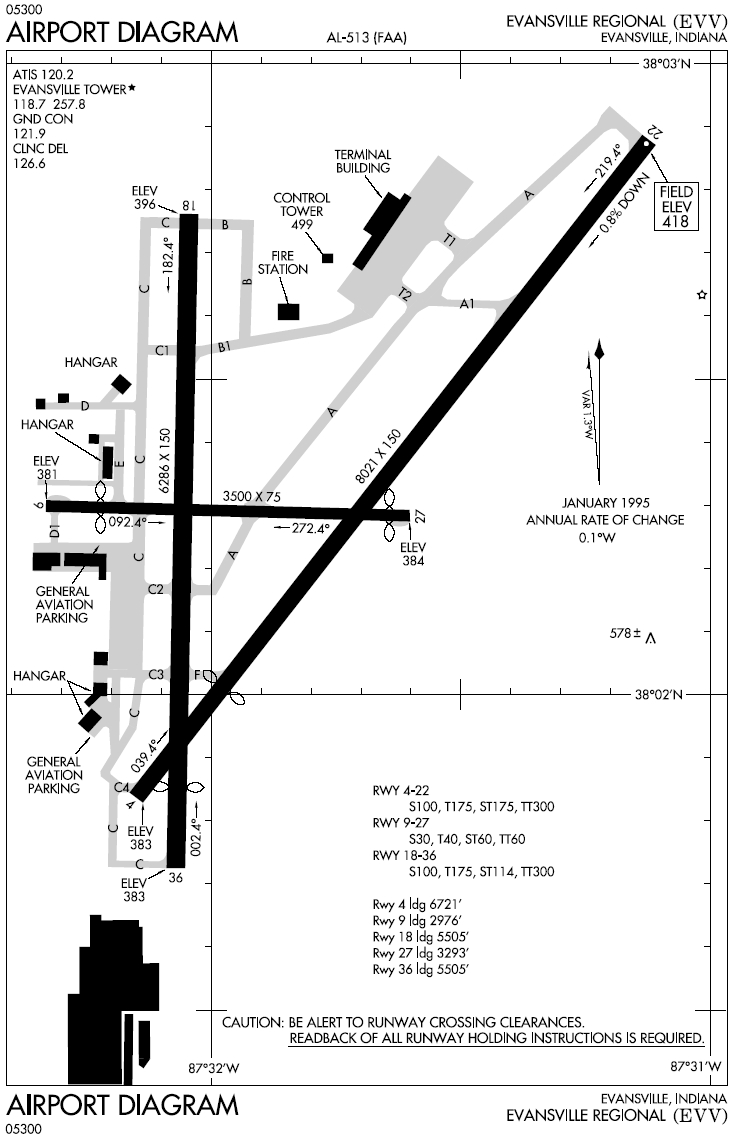
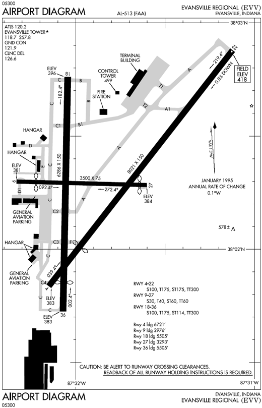
| 4/22 |
8,021 |
2,445 |
Asphalt |
| 9/27 |
3,500 |
1,067 |
Asphalt |
| 18/36 |
6,286 |
1,916 |
Asphalt |
| Source: Federal Aviation Administration |
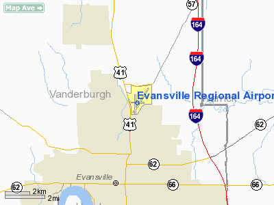
Evansville Regional Airport (IATA: EVV, ICAO: KEVV, FAA LID: EVV) is a public airport located three miles (5 km) north of the central business district of Evansville, a city in Vanderburgh County, Indiana, United States. This airport is publicly owned by Evansville/Vanderburgh Airport Authority.
It provides nearly 30 daily flights to and from national hub-airport locations throughout the United States. These airline hubs consist of Atlanta, Chicago, Cincinnati, Dallas/Fort Worth, Detroit. History
Established in 1928 on 260 acres (1.1 km²) of land along U.S. Highway 41 and funded by a city bond issue, the original airport construction included a small terminal, weather bureau, hangar, runways, boundary lights, grading, and drainage work.
The original terminal was replaced in 1988 with the new William H. Dress Terminal. The new terminal was designed by Hafer Associates and provides 140,000 square feet (13,000 m²) of space and ten carrier gates.
Facilities
EVV has three runways and is equipped with an Instrument Landing System (ILS), providing precision instrument approaches. The airport encompasses 1,400 acres (5.7 km²) and the passenger terminal provides 140,000 square feet (13,000 m²) of space and ten carrier gates.
Airlines and destinations
| Airlines |
Destinations |
| American Eagle |
Chicago-O'Hare, Dallas/Fort Worth |
| Delta Connection operated by Atlantic Southeast Airlines |
Atlanta, Cincinnati/Northern Kentucky |
| Delta Connection operated by Chautauqua Airlines |
Cincinnati/Northern Kentucky |
| Delta Connection operated by Pinnacle Airlines |
Detroit, Memphis |
Accidents
Two aviation accidents have been associated with the area surrounding the airport.
- On December 13, 1977 Douglas C-53 N51071 of National Jet Services crashed on take-off from whilst on a domestic non-scheduled passenger flight to Nashville Metropolitan Airport, Tennessee. All 29 people on board were killed, including the entire University of Evansville basketball team. The cause of the accident was that the gust locks had not been removed and the aircraft was improperly loaded, resulting in an aft CoG.
- On February 6, 1992, a C-130 military transport aircraft operated by the Kentucky Air National Guard, with five crew aboard, crashed at 9:48 A.M. one mile south of the airport in the parking lot of JoJo's restaurant in connection with the Drury Inn on U.S. Highway 41. Sixteen people were killed in the crash and fifteen others were injured. Both JoJo's restaurant and Drury Inn were damaged but were repaired and are still operating just south of the airport although JoJo's is now a Denny's restaurant
The above content comes from Wikipedia and is published under free licenses – click here to read more.
Location
& QuickFacts
|
FAA
Information Effective: |
2007-12-20 |
|
Airport
Identifier: |
EVV |
|
Airport
Status: |
Operational |
|
Longitude/Latitude: |
087-31-56.5141W/38-02-13.1866N
-87.532365/38.036996 (Estimated) |
|
Elevation: |
418 ft / 127.41 m (Surveyed) |
|
Land: |
1250 acres |
|
From nearest
city: |
3 nautical miles N of Evansville, IN |
|
Location: |
Vanderburgh County, IN |
|
Magnetic
Variation: |
00E (1985) |
Owner
& Manager
|
Ownership: |
Publicly
owned |
|
Owner: |
Evansvlle/vanderburg Arpt Auth
EVANSVILLE-VANDERBURGH ARPT AUTHORITY DIST. |
|
Address: |
7801 Bussing Dr
Evansville, IN 47725-6799 |
|
Phone
number: |
812-421-4401 |
|
Manager: |
Robert H Working
ASST MGR GENE OLSON |
|
Address: |
7801 Bussing Dr
Evansville,
IN 47725-6799 |
|
Phone
number: |
812-421-4401 |
Airport
Operations and Facilities
|
Airport
Use: |
Open
to public |
|
Wind indicator: |
Yes |
|
Segmented
Circle: |
Yes |
|
Control
Tower: |
Yes |
|
Lighting
Schedule: |
DUSK-DAWN
HIRL RYS 04/22 & 18/36 ON WHEN ATCT CLSD; INTST LVL
& LGTS RY 09/27 PREDICATED BY WX FORCAST WHEN ATCT CLSD.
ACTVT
MALSR RY 22 - CTAF. |
|
Beacon
Color: |
Clear-Green (lighted land airport) |
|
Landing
fee charge: |
No |
|
Sectional
chart: |
St Louis |
|
Region: |
AGL - Great Lakes |
|
Boundary
ARTCC: |
ZID - Indianapolis |
|
Tie-in
FSS: |
HUF - Terre Haute |
|
FSS on
Airport: |
No |
|
FSS Toll
Free: |
1-800-WX-BRIEF |
|
NOTAMs
Facility: |
EVV (NOTAM-d service avaliable) |
|
Certification
type/date: |
I B S 05/1973
ARPT HAS INDEX C ARFF CAPABILITY - AVAILABLE ON REQUEST;
CALL 812-421-4401. |
|
Federal
Agreements: |
NGPRY3 |
Airport Communications
|
CTAF: |
118.700 |
|
Unicom: |
122.950
|
Airport
Services
|
Fuel
available: |
100LLA |
|
Airframe
Repair: |
MAJOR |
|
Power
Plant Repair: |
MAJOR |
|
Bottled
Oxygen: |
HIGH |
|
Bulk Oxygen: |
NONE |
|
Runway Information
Runway 04/22
|
Dimension: |
8021 x 150 ft
/ 2444.8 x 45.7 m |
|
Surface: |
ASPH, Good Condition |
|
Surface Treatment: |
Saw-cut or plastic Grooved |
|
Weight Limit: |
Single wheel: 100000 lbs.
Dual wheel: 175000 lbs.
Dual tandem wheel: 300000 lbs.
; 18/36 & TWYS C; H & E RSTRD TO ACFT LESS THAN 50000 LBS. |
|
Edge Lights: |
High |
|
|
Runway 04 |
Runway 22 |
|
Longitude: |
087-32-09.3380W |
087-31-07.4850W |
|
Latitude: |
38-01-50.3260N |
38-02-52.7330N |
|
Elevation: |
383.00 ft |
418.00 ft |
|
Alignment: |
38 |
127 |
|
ILS Type: |
ILS |
ILS |
|
Traffic
Pattern: |
Left |
Left |
|
Markings: |
Precision instrument, Good Condition |
Precision instrument, Good Condition |
|
Crossing
Height: |
52.00 ft |
0.00 ft |
|
Displaced
threshold: |
1300.00 ft |
0.00 ft |
|
VASI: |
4-box on left side |
|
|
Visual Glide
Angle: |
3.00° |
0.00° |
|
RVR Equipment: |
|
touchdown |
|
Approach
lights: |
|
MALSR |
|
Runway End
Identifier: |
Yes |
No |
|
Centerline
Lights: |
No |
No |
|
Touchdown
Lights: |
No |
No |
|
Obstruction: |
44 ft bldg, 1128.0 ft from runway, 528 ft right
of centerline, 21:1 slope to clear
APCH RATIO 42:1 AT DSPLCD THLD OVER 106 FT TREES 4553 FT FM
THLD 339 FT LEFT. |
, 50:1 slope to clear |
|
Runway 09/27
|
Dimension: |
3500 x 75 ft
/ 1066.8 x 22.9 m |
|
Surface: |
ASPH, Good Condition |
|
Weight Limit: |
Single wheel: 30000 lbs.
Dual wheel: 40000 lbs.
Dual tandem wheel: 60000 lbs.
; 18/36 & TWYS C; H & E RSTRD TO ACFT LESS THAN 50000 LBS. |
|
Edge Lights: |
Medium |
|
|
Runway 09 |
Runway 27 |
|
Longitude: |
087-32-19.8630W |
087-31-36.1200W |
|
Latitude: |
38-02-17.9130N |
38-02-17.2230N |
|
Elevation: |
381.00 ft |
384.00 ft |
|
Alignment: |
91 |
127 |
|
Traffic
Pattern: |
Left |
Left |
|
Markings: |
Basic, Good Condition |
Basic, Good Condition |
|
Displaced
threshold: |
524.00 ft |
207.00 ft |
|
Runway End
Identifier: |
No |
No |
|
Centerline
Lights: |
No |
No |
|
Touchdown
Lights: |
No |
No |
|
Obstruction: |
14 ft road, 375.0 ft from runway, 250 ft right
of centerline, 12:1 slope to clear
APCH RATIO 20:1 AT DSPLCD THLD OVER 60 FT TREES 1400 FT FM
THLD 250 FT L. |
17 ft road, 268.0 ft from runway, 4:1 slope
to clear
APCH RATIO 26:1 AT DSPLCD THLD OVER 18 FT ROAD 475 FT FM THLD
13 FT LEFT. |
|
Runway 18/36
|
Dimension: |
6286 x 150 ft
/ 1916.0 x 45.7 m |
|
Surface: |
ASPH, Good Condition |
|
Surface Treatment: |
Saw-cut or plastic Grooved |
|
Weight Limit: |
Single wheel: 100000 lbs.
Dual wheel: 175000 lbs.
Dual tandem wheel: 300000 lbs.
; 18/36 & TWYS C; H & E RSTRD TO ACFT LESS THAN 50000 LBS. |
|
Edge Lights: |
Medium |
|
|
Runway 18 |
Runway 36 |
|
Longitude: |
087-32-02.6951W |
087-32-04.2651W |
|
Latitude: |
38-02-45.6506N |
38-01-43.5181N |
|
Elevation: |
396.00 ft |
383.00 ft |
|
Alignment: |
127 |
1 |
|
Traffic
Pattern: |
Left |
Left |
|
Markings: |
Basic, Good Condition |
Non-precision instrument, Good Condition |
|
Crossing
Height: |
62.00 ft |
29.00 ft |
|
Displaced
threshold: |
0.00 ft |
781.00 ft |
|
VASI: |
4-light PAPI on right side |
4-light PAPI on left side |
|
Visual Glide
Angle: |
3.66° |
3.00° |
|
Runway End
Identifier: |
No |
No |
|
Centerline
Lights: |
No |
No |
|
Touchdown
Lights: |
No |
No |
|
Obstruction: |
65 ft pole, 1430.0 ft from runway, 300 ft left
of centerline, 19:1 slope to clear |
15 ft road, 277.0 ft from runway, 10 ft right
of centerline, 5:1 slope to clear
APCH RATIO 25:1 AT DSPLCD THLD OVER 51 FT LGTD BLDG 1296 FT
FM THLD 308 FT LEFT; APCH RATIO 50:1 AT DSPLCD THLD OVER ROAD. |
|
Decleard
distances: |
Take off run available 5505.00 ft
Take off distance available 5505.00 ft
Actual stop distance available 5505.00 ft
Landing distance available 5505.00 ft |
Take off run available 6286.00 ft
Take off distance available 6286.00 ft
Actual stop distance available 6286.00 ft
Landing distance available 5505.00 ft |
|
Radio Navigation
Aids
|
ID |
Type |
Name |
Ch |
Freq |
Var |
Dist |
|
PDW |
NDB |
Evansville |
|
284.00 |
00E |
0.2 nm |
|
GVA |
NDB |
Geneva |
|
224.00 |
01W |
18.0 nm |
|
CUL |
NDB |
Carmi |
|
332.00 |
01W |
28.0 nm |
|
FNZ |
NDB |
Ferdinand |
|
239.00 |
00E |
35.2 nm |
|
AJG |
NDB |
Mount Carmel |
|
524.00 |
02W |
35.7 nm |
|
OEA |
NDB |
Vincennes |
|
251.00 |
00E |
39.4 nm |
|
TWT |
NDB |
Tradewater |
|
276.00 |
00E |
39.5 nm |
|
TEL |
NDB |
Tell City |
|
206.00 |
02W |
39.9 nm |
|
DCY |
NDB |
Washington |
|
212.00 |
03W |
43.9 nm |
|
FWC |
NDB |
Wayne County |
|
257.00 |
01E |
46.3 nm |
|
HSB |
NDB |
Harrisburg-raleigh |
|
230.00 |
00E |
49.9 nm |
|
OWB |
VOR/DME |
Owensboro |
023X |
108.60 |
01E |
24.8 nm |
|
HNB |
VOR/DME |
Huntingburg |
029X |
109.20 |
00E |
30.1 nm |
|
SAM |
VOR/DME |
Samsville |
113X |
116.60 |
03E |
37.5 nm |
|
LWV |
VOR/DME |
Lawrenceville |
025X |
108.80 |
01W |
44.2 nm |
|
PXV |
VORTAC |
Pocket City |
080X |
113.30 |
03E |
12.7 nm |
|
CCT |
VORTAC |
Central City |
035X |
109.80 |
01W |
41.4 nm |
Remarks
- BIRDS
ON & INVOF ARPT.
- RY
04 & RY 36 APCH ENDS ARE CLOSELY ALIGNED. VERIFY CORRECT RY AND
COMPASS HEADING PRIOR TO DEP.
Based Aircraft
|
Aircraft
based on field: |
75 |
|
Single Engine
Airplanes: |
52 |
|
Multi Engine Airplanes: |
16 |
|
Jet Engine Airplanes: |
7 |
Major Carriers
Serving This Airport
|
American Eagle Airlines Inc. |
69.8% |
|
Comair Inc. |
17.0% |
|
Atlantic Southeast Airlines |
13.1% |
Most Popular Destinations
|
Chicago O'hare
Intl (ORD) |
59.2% |
|
Cincinnati/northern
Kentucky Intl (CVG) |
16.9% |
|
Hartsfield
- Jackson Atlanta Intl (ATL) |
13.1% |
|
Dallas/fort
Worth Intl (DFW) |
10.7% |
|
Lambert-st
Louis Intl (STL) |
0.1% |
Most Popular Aircraft
|
N616AE |
1.5% |
|
N908AE |
1.5% |
|
N902BC |
1.4% |
|
N906AE |
1.3% |
|
N618AE |
1.3% |
|
N678AE |
1.3% |
|
N922AE |
1.2% |
|
N687JS |
1.2% |
|
N610AE |
1.2% |
|
N933JN |
1.2% |
Operational Statistics
Time
Period: 2005-01-01 - 2005-12-31
|
Aircraft
Operations: |
186/Day |
|
Commerical: |
0.3% |
|
Air Taxi: |
33.3% |
|
General Aviation
Local: |
28.1% |
|
General Aviation
Itinerant: |
37.0% |
|
Military: |
1.4% |
Evansville Regional Airport
Address:
Vanderburgh County, IN
Tel:
812-421-4401
Images
and information placed above are from
http://www.airport-data.com/airport/EVV/
We
thank them for the data!
| General
Info |
| Country |
United
States |
| State |
INDIANA
|
| FAA ID |
EVV |
| Latitude |
38-02-16.769N
|
| Longitude |
087-31-50.256W
|
| Elevation |
418 feet
|
| Near City |
EVANSVILLE
|
We don't guarantee the information is fresh and accurate. The data may
be wrong or outdated.
For more up-to-date information please refer to other sources.
|
|