 |
|
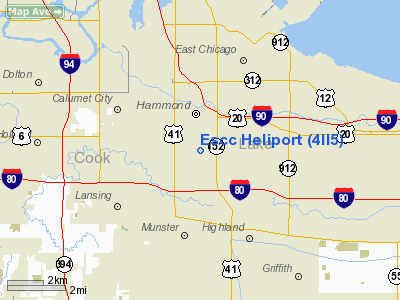
Location
& QuickFacts
|
FAA
Information Effective: |
2007-12-20 |
|
Airport
Identifier: |
4II5 |
|
Airport
Status: |
Operational |
|
Longitude/Latitude: |
087-29-29.0000W/41-35-39.0000N
-87.491389/41.594167 (Estimated) |
|
Elevation: |
600 ft / 182.88 m (Estimated) |
|
Land: |
0 acres |
|
From nearest
city: |
0 nautical miles N of Hammond, IN |
|
Location: |
Lake County, IN |
|
Magnetic
Variation: |
02W (1990) |
Owner
& Manager
|
Ownership: |
Privately
owned |
|
Owner: |
Northern Indianna Public Svc |
|
Address: |
1705 E Main St
Griffith,
IN 46319 |
|
Manager: |
Michael Kwiat |
|
Address: |
1705 E Main St
Griffith,
IN 46319 |
|
Phone
number: |
219-853-5095 |
Airport Operations
and Facilities
|
Airport
Use: |
Private |
|
Wind indicator: |
Yes |
|
Segmented
Circle: |
No |
|
Control
Tower: |
No |
|
Lighting
Schedule: |
PHONE REQ
FOR PERIMETER LGTS PHONE 219-853-5095. |
|
Sectional
chart: |
Chicago |
|
Region: |
AGL - Great Lakes |
|
Boundary
ARTCC: |
ZAU - Chicago |
|
Tie-in
FSS: |
HUF - Terre Haute |
|
FSS Toll
Free: |
1-800-WX-BRIEF |
|
Runway Information
Helipad H1
|
Dimension: |
30 x 30 ft /
9.1 x 9.1 m |
|
Surface: |
CONC, |
|
|
Runway H1 |
Runway |
|
Traffic
Pattern: |
Left |
Left |
|
Radio Navigation
Aids
|
ID |
Type |
Name |
Ch |
Freq |
Var |
Dist |
|
MX |
NDB |
Kedzi |
|
248.00 |
01W |
12.6 nm |
|
HK |
NDB |
Ermin |
|
332.00 |
01W |
17.2 nm |
|
VP |
NDB |
Sedly |
|
212.00 |
02W |
28.9 nm |
|
MGC |
NDB |
Michigan City |
|
203.00 |
01W |
31.1 nm |
|
ME |
NDB |
Deana |
|
350.00 |
00E |
32.9 nm |
|
IUL |
NDB |
La Porte |
|
356.00 |
03W |
32.9 nm |
|
RZL |
NDB |
Rensselaer |
|
362.00 |
02W |
41.3 nm |
|
ORD |
VOR/DME |
Chicago O'hare |
086X |
113.90 |
02E |
30.0 nm |
|
IKK |
VOR/DME |
Kankakee |
053X |
111.60 |
00E |
35.2 nm |
|
OXI |
VOR/DME |
Knox |
103X |
115.60 |
00E |
41.3 nm |
|
DPA |
VOR/DME |
Dupage |
021X |
108.40 |
02E |
42.4 nm |
|
OBK |
VOR/DME |
Northbrook |
077X |
113.00 |
02W |
43.0 nm |
|
CGT |
VORTAC |
Chicago Heights |
089X |
114.20 |
02E |
6.2 nm |
|
EON |
VORTAC |
Peotone |
079X |
113.20 |
02E |
23.7 nm |
|
JOT |
VORTAC |
Joliet |
070X |
112.30 |
02E |
37.3 nm |
|
MDW |
VOT |
Chicago Midway |
|
111.00 |
|
16.4 nm |
|
ORD |
VOT |
Chicago O'hare Intl |
|
112.00 |
|
29.9 nm |
Remarks
- OPERS
COND FM 155 TO 65 DEGS; AREA IS MKD; WIND IND MAINTAINED; NO NGT OPERS
UNLESS LGTD; TREES NE TRIMMED TO BLO 8:1 SLOPE; FAR91 IS COMPLIED WITH.
Escc Heliport
Address:
Lake County, IN
Tel:
219-853-5095
Images
and information placed above are from
http://www.airport-data.com/airport/4II5/
We
thank them for the data!
| General
Info |
| Country |
United
States |
| State |
INDIANA
|
| FAA ID |
4II5 |
| Latitude |
41-35-39.000N
|
| Longitude |
087-29-29.000W
|
| Elevation |
600 feet
|
| Near City |
HAMMOND
|
We don't guarantee the information is fresh and accurate. The data may
be wrong or outdated.
For more up-to-date information please refer to other sources.
|
|


