 |
|
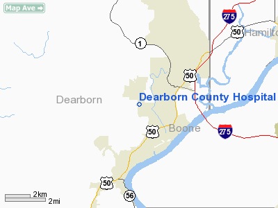
Dearborn County Hospital Heliport |
Location
& QuickFacts
|
FAA
Information Effective: |
2007-12-20 |
|
Airport
Identifier: |
IN94 |
|
Airport
Status: |
Operational |
|
Longitude/Latitude: |
084-53-02.8250W/39-06-42.2050N
-84.884118/39.111724 (Estimated) |
|
Elevation: |
879 ft / 267.92 m (Estimated) |
|
Land: |
0 acres |
|
From nearest
city: |
1 nautical miles N of Lawrenceburg, IN |
|
Location: |
Dearborn County, IN |
|
Magnetic
Variation: |
03W (1985) |
Owner
& Manager
|
Ownership: |
Privately
owned |
|
Owner: |
Dearborn County Hospital |
|
Address: |
600 Wilson Creek Road
Lawrenceburg,
IN 47025 |
|
Phone
number: |
812-537-8120 |
|
Manager: |
Steven Karsteter, Dir |
|
Address: |
600 Wilson Creek Road
Lawrenceburg,
IN 47025 |
|
Phone
number: |
812-537-8120 |
Airport Operations
and Facilities
|
Airport
Use: |
Private
MEDICAL USE. |
|
Wind indicator: |
Yes |
|
Segmented
Circle: |
No |
|
Control
Tower: |
No |
|
Sectional
chart: |
Cincinnati |
|
Region: |
AGL - Great Lakes |
|
Boundary
ARTCC: |
ZID - Indianapolis |
|
Tie-in
FSS: |
HUF - Terre Haute |
|
FSS Toll
Free: |
1-800-WX-BRIEF |
|
Runway Information
Helipad H1
|
Dimension: |
24 x 24 ft /
7.3 x 7.3 m |
|
Surface: |
CONC,
ROOFTOP. |
|
|
Runway H1 |
Runway |
|
Traffic
Pattern: |
Left |
Left |
|
Radio Navigation
Aids
|
ID |
Type |
Name |
Ch |
Freq |
Var |
Dist |
|
UR |
NDB |
Burln |
|
321.00 |
04W |
6.5 nm |
|
HAO |
NDB |
Hamilton |
|
260.00 |
04W |
21.4 nm |
|
HLB |
NDB |
Batesville |
|
254.00 |
02W |
22.5 nm |
|
OXD |
NDB |
Oxford |
|
282.00 |
04W |
24.3 nm |
|
ISZ |
NDB |
Cincinnati-blue Ash |
|
388.00 |
04W |
24.5 nm |
|
LUK |
NDB |
Cincinnati |
|
335.00 |
04W |
25.5 nm |
|
MDE |
NDB |
Madeira |
|
379.00 |
04W |
25.5 nm |
|
HKF |
NDB |
Hook Field |
|
239.00 |
04W |
30.9 nm |
|
PWF |
NDB |
Sportys |
|
245.00 |
04W |
31.3 nm |
|
OVO |
NDB |
North Vernon |
|
374.00 |
02W |
33.7 nm |
|
IMS |
NDB |
Madison |
|
404.00 |
03W |
34.2 nm |
|
BA |
NDB |
Clifs |
|
410.00 |
03W |
45.3 nm |
|
HW |
NDB |
Cubla |
|
299.00 |
04W |
49.1 nm |
|
FLM |
VOR/DME |
Falmouth |
117X |
117.00 |
04W |
38.6 nm |
|
CVG |
VORTAC |
Cincinnati |
120X |
117.30 |
04W |
10.2 nm |
|
RID |
VORTAC |
Richmond |
043X |
110.60 |
03W |
38.7 nm |
|
ABB |
VORTAC |
Nabb |
071X |
112.40 |
01E |
47.2 nm |
|
LUK |
VOT |
Cincinnati Muni/lunken |
|
108.40 |
|
22.6 nm |
Remarks
- DIRECTOR
OF PLANT OPERATIONS AND SAFETY
- PROVIDED
APP/DEP FROM 050 TO 360 DEGS; AREA IS MARKED; WIND INDICATOR IS MAINTAINED.
Dearborn County Hospital Heliport
Address:
Dearborn County, IN
Tel:
812-537-8120
Images
and information placed above are from
http://www.airport-data.com/airport/IN94/
We
thank them for the data!
| General
Info |
| Country |
United
States |
| State |
INDIANA
|
| FAA ID |
IN94 |
| Latitude |
39-06-42.205N
|
| Longitude |
084-53-02.825W
|
| Elevation |
879 feet
|
| Near City |
LAWRENCEBURG
|
We don't guarantee the information is fresh and accurate. The data may
be wrong or outdated.
For more up-to-date information please refer to other sources.
|
|


