 |
|
| Daviess County Airport |
| IATA: none – ICAO: KDCY – FAA LID: DCY |
| Summary |
| Airport type |
Public |
| Owner |
Daviess County BOAC |
| Serves |
Washington, Indiana |
| Elevation AMSL |
473 ft / 144 m |
| Coordinates |
38°42′02″N 087°07′47″W / 38.70056°N 87.12972°W / 38.70056; -87.12972 |
| Runways |
| Direction |
Length |
Surface |
| ft |
m |
| 18/36 |
4,621 |
1,408 |
Asphalt |
| Statistics (2006) |
| Aircraft operations |
8,912 |
| Based aircraft |
26 |
| Source: Federal Aviation Administration |
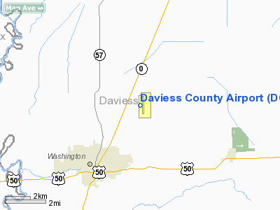
Daviess County Airport (ICAO: KDCY, FAA LID: DCY) is a county-owned public-use airport located three nautical miles (6 km) northeast of the central business district of Washington, a city in Daviess County, Indiana, United States.
Although most U.S. airports use the same three-letter location identifier for the FAA and IATA, this airport is assigned DCY by the FAA but has no designation from the IATA.
Facilities and aircraft
Daviess County Airport covers an area of 25 acres (10 ha) at an elevation of 473 feet (144 m) above mean sea level. It has one asphalt paved runway designated 18/36 which measures 4,621 by 75 feet (1,408 x 23 m).
For the 12-month period ending December 31, 2006, the airport had 8,912 aircraft operations, an average of 24 per day: 99% general aviation and 1% air taxi, At that time there were 26 aircraft based at this airport: 81% single-engine and 19% multi-engine.
The above content comes from Wikipedia and is published under free licenses – click here to read more.
Location
& QuickFacts
|
FAA
Information Effective: |
2007-12-20 |
|
Airport
Identifier: |
DCY |
|
Airport
Status: |
Operational |
|
Longitude/Latitude: |
087-07-47.0360W/38-42-01.5240N
-87.129732/38.700423 (Estimated) |
|
Elevation: |
473 ft / 144.17 m (Surveyed) |
|
Land: |
25 acres |
|
From nearest
city: |
3 nautical miles NE of Washington, IN |
|
Location: |
Daviess County, IN |
|
Magnetic
Variation: |
03W (2005) |
Owner
& Manager
|
Ownership: |
Publicly
owned |
|
Owner: |
Daviess County Boac
BOB BARRON - PRESIDENT. |
|
Address: |
P. O. Box 2338
Washington,
IN 47501 |
|
Phone
number: |
812-254-9934 |
|
Manager: |
Jack Miles |
|
Address: |
P. O. Box 2338
Washington,
IN 47501 |
|
Phone
number: |
812-254-9934
FAX 812-254-9734 |
Airport Operations
and Facilities
|
Airport
Use: |
Open
to public |
|
Wind indicator: |
Yes |
|
Segmented
Circle: |
Yes |
|
Control
Tower: |
No |
|
Lighting
Schedule: |
DUSK-DAWN
FOR MIRL 18/36 & REIL RYS 18 & 36 KEY 122.8 3 TIMES. |
|
Beacon
Color: |
Clear-Green (lighted land airport) |
|
Landing
fee charge: |
No |
|
Sectional
chart: |
St Louis |
|
Region: |
AGL - Great Lakes |
|
Boundary
ARTCC: |
ZID - Indianapolis |
|
Tie-in
FSS: |
HUF - Terre Haute |
|
FSS on
Airport: |
No |
|
FSS Toll
Free: |
1-800-WX-BRIEF |
|
NOTAMs
Facility: |
HUF (NOTAM-d service avaliable) |
|
Federal
Agreements: |
NGY |
Airport Communications
|
CTAF: |
122.800 |
|
Unicom: |
122.800
|
Airport
Services
|
Fuel
available: |
100LLA |
|
Airframe
Repair: |
MAJOR |
|
Power
Plant Repair: |
MAJOR |
|
Bottled
Oxygen: |
NONE |
|
Bulk Oxygen: |
NONE |
|
Runway Information
Runway 18/36
|
Dimension: |
4621 x 75 ft
/ 1408.5 x 22.9 m |
|
Surface: |
ASPH, Fair Condition |
|
Weight Limit: |
Single wheel: 10000 lbs.
Dual wheel: 44000 lbs. |
|
Edge Lights: |
Medium |
|
|
Runway 18 |
Runway 36 |
|
Longitude: |
087-07-47.0220W |
087-07-47.0150W |
|
Latitude: |
38-42-24.3650N |
38-41-38.6880N |
|
Elevation: |
458.00 ft |
467.00 ft |
|
Alignment: |
127 |
127 |
|
Traffic
Pattern: |
Left |
Left |
|
Markings: |
Non-precision instrument, Fair Condition |
Non-precision instrument, Fair Condition |
|
Displaced
threshold: |
315.00 ft |
0.00 ft |
|
VASI: |
2-light PAPI on left side |
2-light PAPI on left side |
|
Runway End
Identifier: |
Yes
REIL OTS INDEFLY. |
Yes |
|
Centerline
Lights: |
No |
No |
|
Touchdown
Lights: |
No |
No |
|
Obstruction: |
14 ft road, 300.0 ft from runway, 7:1 slope
to clear
APCH SLOPE 43:1 TO DSPLCD THLD. |
53 ft trees, 1350.0 ft from runway, 21:1 slope
to clear |
|
Radio Navigation
Aids
|
ID |
Type |
Name |
Ch |
Freq |
Var |
Dist |
|
DCY |
NDB |
Washington |
|
212.00 |
03W |
0.3 nm |
|
OEA |
NDB |
Vincennes |
|
251.00 |
00E |
20.0 nm |
|
AJG |
NDB |
Mount Carmel |
|
524.00 |
02W |
28.5 nm |
|
SIV |
NDB |
Sullivan |
|
326.00 |
02W |
28.9 nm |
|
RRJ |
NDB |
Oranj |
|
368.00 |
02W |
30.1 nm |
|
FNZ |
NDB |
Ferdinand |
|
239.00 |
00E |
30.4 nm |
|
PLX |
NDB |
Palestine |
|
391.00 |
00W |
30.4 nm |
|
BM |
NDB |
Claye |
|
382.00 |
02W |
32.8 nm |
|
BFR |
NDB |
Bedford |
|
344.00 |
02W |
33.5 nm |
|
HU |
NDB |
Yinno |
|
245.00 |
02W |
43.2 nm |
|
PDW |
NDB |
Evansville |
|
284.00 |
00E |
44.0 nm |
|
TEL |
NDB |
Tell City |
|
206.00 |
02W |
46.2 nm |
|
OLY |
NDB |
Olney |
|
272.00 |
00W |
48.9 nm |
|
LWV |
VOR/DME |
Lawrenceville |
025X |
108.80 |
01W |
22.6 nm |
|
HNB |
VOR/DME |
Huntingburg |
029X |
109.20 |
00E |
28.3 nm |
|
RSV |
VOR/DME |
Robinson |
021X |
108.40 |
02E |
30.9 nm |
|
SAM |
VOR/DME |
Samsville |
113X |
116.60 |
03E |
46.7 nm |
|
OOM |
VORTAC |
Hoosier |
039X |
110.20 |
02W |
36.0 nm |
|
TTH |
VORTAC |
Terre Haute |
100X |
115.30 |
02E |
47.7 nm |
Based Aircraft
|
Aircraft
based on field: |
26 |
|
Single Engine
Airplanes: |
21 |
|
Multi Engine Airplanes: |
5 |
Operational Statistics
Time
Period: 2006-01-01 - 2006-12-31
|
Aircraft
Operations: |
172/Week |
|
Air Taxi: |
1.1% |
|
General Aviation
Local: |
84.0% |
|
General Aviation
Itinerant: |
14.9% |
Daviess County Airport
Address:
Daviess County, IN
Tel:
812-254-9934
Fax: 812-254-9734
Images
and information placed above are from
http://www.airport-data.com/airport/DCY/
We
thank them for the data!
| General
Info |
| Country |
United
States |
| State |
INDIANA
|
| FAA ID |
DCY |
| Latitude |
38-42-01.524N
|
| Longitude |
087-07-47.036W
|
| Elevation |
473 feet
|
| Near City |
WASHINGTON
|
We don't guarantee the information is fresh and accurate. The data may
be wrong or outdated.
For more up-to-date information please refer to other sources.
|
|


