 |
|
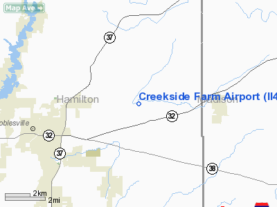
Location
& QuickFacts
|
FAA
Information Effective: |
2007-12-20 |
|
Airport
Identifier: |
II42 |
|
Airport
Status: |
Operational |
|
Longitude/Latitude: |
085-55-19.9300W/40-04-07.1300N
-85.922203/40.068647 (Estimated) |
|
Elevation: |
800 ft / 243.84 m (Estimated) |
|
Land: |
0 acres |
|
From nearest
city: |
5 nautical
miles NE of Noblesville, IN |
|
Location: |
Hamilton
County, IN |
|
Magnetic
Variation: |
03W (1990) |
Owner & Manager
|
Ownership: |
Privately
owned |
|
Owner: |
Michael E. Warren |
|
Address: |
13620 E. 191 St
Noblesville, IN 46060 |
|
Phone
number: |
317-581-5286 |
|
Manager: |
Michael E. Warren |
|
Address: |
13620 E. 191 St
Noblesville, IN 46060 |
|
Phone
number: |
317-581-5286 |
Airport
Operations and Facilities
|
Airport
Use: |
Private |
|
Segmented
Circle: |
No |
|
Control
Tower: |
No |
|
Sectional
chart: |
St Louis |
|
Region: |
AGL - Great Lakes |
|
Boundary
ARTCC: |
ZID - Indianapolis |
|
Tie-in
FSS: |
HUF - Terre Haute |
|
FSS Toll
Free: |
1-800-WX-BRIEF |
|
Runway Information
Runway 05/23
|
Dimension: |
1600 x 60 ft
/ 487.7 x 18.3 m |
|
Surface: |
TURF, |
|
|
Runway 05 |
Runway 23 |
|
Traffic
Pattern: |
Left |
Left |
|
Radio Navigation
Aids
|
ID |
Type |
Name |
Ch |
Freq |
Var |
Dist |
|
UMP |
NDB |
Metropolitan |
|
338.00 |
03W |
9.8 nm |
|
HZP |
NDB |
Zionsville |
|
248.00 |
03W |
16.9 nm |
|
AI |
NDB |
Video |
|
371.00 |
03W |
18.9 nm |
|
HFY |
NDB |
Greenwood |
|
398.00 |
02W |
27.3 nm |
|
UWL |
NDB |
New Castle |
|
385.00 |
02W |
30.0 nm |
|
FKR |
NDB |
Frankfort |
|
278.00 |
02W |
31.8 nm |
|
IWH |
NDB |
Wabash |
|
329.00 |
03W |
42.2 nm |
|
GGP |
NDB |
Logansport |
|
263.00 |
01W |
43.7 nm |
|
BA |
NDB |
Clifs |
|
410.00 |
03W |
45.1 nm |
|
TVX |
NDB |
Greencastle |
|
521.00 |
03W |
46.0 nm |
|
CFJ |
NDB |
Crawfordsville |
|
388.00 |
02W |
46.0 nm |
|
PLD |
NDB |
Portland |
|
257.00 |
03W |
48.9 nm |
|
MIE |
VOR/DME |
Muncie |
091X |
114.40 |
03W |
26.3 nm |
|
MZZ |
VOR/DME |
Marion |
023X |
108.60 |
03W |
27.9 nm |
|
VHP |
VORTAC |
Brickyard |
110X |
116.30 |
01E |
25.6 nm |
|
SHB |
VORTAC |
Shelbyville |
057X |
112.00 |
01E |
26.6 nm |
|
OKK |
VORTAC |
Kokomo |
082X |
113.50 |
00E |
28.3 nm |
|
GUS |
VORTAC |
Grissom |
21Y |
108.45 |
02W |
36.2 nm |
|
IND |
VOT |
Indianapolis Intl |
|
109.60 |
|
26.6 nm |
Remarks
- PRVDD
THE AREA 125 FT EITHER SIDE OF RWY CNTRLN & 200 FT OFF RY END BE
CLEAR OF ANY OBSTN & ANY OBSTN IN THE RY APCH SLOPE ARE REMOVED/LOWERED
OR THE RY THR IS DSPLCD & MKD FOR 20:1 APCH CLNC.
Based Aircraft
|
Aircraft
based on field: |
1 |
|
Single Engine
Airplanes: |
1 |
Creekside Farm Airport
Address:
Hamilton County, IN
Tel:
317-581-5286
Images
and information placed above are from
http://www.airport-data.com/airport/II42/
We
thank them for the data!
We don't guarantee the information is fresh and accurate. The data may
be wrong or outdated.
For more up-to-date information please refer to other sources.
|
|


