 |
|
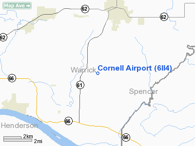
Location
& QuickFacts
|
FAA
Information Effective: |
2007-12-20 |
|
Airport
Identifier: |
6II4 |
|
Airport
Status: |
Operational |
|
Longitude/Latitude: |
087-17-56.0000W/37-58-56.0000N
-87.298889/37.982222 (Estimated) |
|
Elevation: |
390 ft / 118.87 m (Estimated) |
|
Land: |
0 acres |
|
From nearest
city: |
5 nautical miles S of Boonville, IN |
|
Location: |
Warrick County, IN |
|
Magnetic
Variation: |
01W (1995) |
Owner
& Manager
|
Ownership: |
Privately
owned |
|
Owner: |
Guy Cornell Jr |
|
Address: |
5022 S Yankeetown Hwy
Boonville,
IN 47601 |
|
Phone
number: |
812-853-8296 |
|
Manager: |
Guy Cornell Jr |
|
Address: |
5022 S Yankeetown Hwy
Boonville,
IN 47601 |
|
Phone
number: |
812-853-8296 |
Airport Operations
and Facilities
|
Airport
Use: |
Private |
|
Segmented
Circle: |
No |
|
Control
Tower: |
No |
|
Sectional
chart: |
St Louis |
|
Region: |
AGL - Great Lakes |
|
Boundary
ARTCC: |
ZID - Indianapolis |
|
Tie-in
FSS: |
HUF - Terre Haute |
|
FSS on
Airport: |
No |
|
FSS Toll
Free: |
1-800-WX-BRIEF |
|
Runway Information
Runway 09/27
|
Dimension: |
3400 x 30 ft
/ 1036.3 x 9.1 m |
|
Surface: |
ASPH, |
|
|
Runway 09 |
Runway 27 |
|
Traffic
Pattern: |
Left |
Left |
|
Obstruction: |
98 ft pline, 2300.0 ft from runway |
|
|
Radio Navigation
Aids
|
ID |
Type |
Name |
Ch |
Freq |
Var |
Dist |
|
PDW |
NDB |
Evansville |
|
284.00 |
00E |
11.5 nm |
|
GVA |
NDB |
Geneva |
|
224.00 |
01W |
24.8 nm |
|
FNZ |
NDB |
Ferdinand |
|
239.00 |
00E |
27.1 nm |
|
TEL |
NDB |
Tell City |
|
206.00 |
02W |
28.9 nm |
|
CUL |
NDB |
Carmi |
|
332.00 |
01W |
39.4 nm |
|
AJG |
NDB |
Mount Carmel |
|
524.00 |
02W |
42.9 nm |
|
DCY |
NDB |
Washington |
|
212.00 |
03W |
43.6 nm |
|
TWT |
NDB |
Tradewater |
|
276.00 |
00E |
43.7 nm |
|
OEA |
NDB |
Vincennes |
|
251.00 |
00E |
44.3 nm |
|
GMH |
NDB |
Muhlenberg |
|
362.00 |
01E |
45.9 nm |
|
RRJ |
NDB |
Oranj |
|
368.00 |
02W |
49.0 nm |
|
OWB |
VOR/DME |
Owensboro |
023X |
108.60 |
01E |
15.7 nm |
|
HNB |
VOR/DME |
Huntingburg |
029X |
109.20 |
00E |
22.8 nm |
|
SAM |
VOR/DME |
Samsville |
113X |
116.60 |
03E |
47.9 nm |
|
LWV |
VOR/DME |
Lawrenceville |
025X |
108.80 |
01W |
49.5 nm |
|
PXV |
VORTAC |
Pocket City |
080X |
113.30 |
03E |
22.2 nm |
|
CCT |
VORTAC |
Central City |
035X |
109.80 |
01W |
36.1 nm |
Remarks
- 600
FT TOWER 1 MILE NE OF ARPT.
- PRVDD
AREA 125 FT EITHER SIDE OF RY & 200 FT OFF RY ENDS BE CLEAR; ANY
OBSTN IN APCH BE REMOVED OR LOWERED OR THLD DSPLCD TO PRVD A CLEAR 20:1.
Based Aircraft
|
Aircraft
based on field: |
1 |
|
Single Engine
Airplanes: |
1 |
Cornell Airport
Address:
Warrick County, IN
Tel:
812-853-8296
Images
and information placed above are from
http://www.airport-data.com/airport/6II4/
We
thank them for the data!
| General
Info |
| Country |
United
States |
| State |
INDIANA
|
| FAA ID |
6II4 |
| Latitude |
37-58-56.000N
|
| Longitude |
087-17-56.000W
|
| Elevation |
390 feet
|
| Near City |
BOONVILLE
|
We don't guarantee the information is fresh and accurate. The data may
be wrong or outdated.
For more up-to-date information please refer to other sources.
|
|


