 |
|
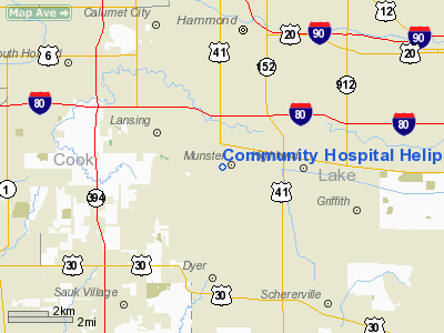
Community Hospital Lake Heliport |
Location
& QuickFacts
|
FAA
Information Effective: |
2007-12-20 |
|
Airport
Identifier: |
IN28 |
|
Airport
Status: |
Operational |
|
Longitude/Latitude: |
087-30-25.1460W/41-33-03.1270N
-87.506985/41.550869 (Estimated) |
|
Elevation: |
616 ft / 187.76 m (Estimated) |
|
Land: |
0 acres |
|
From nearest
city: |
0 nautical miles S of Munster, IN |
|
Location: |
Lake County, IN |
|
Magnetic
Variation: |
01W (1985) |
Owner
& Manager
|
Ownership: |
Privately
owned |
|
Owner: |
Munster Med Res Foun |
|
Address: |
901 Mac Arthur Blvd
Munster,
IN 46321 |
|
Phone
number: |
219-836-1600 |
|
Manager: |
David B Nellans |
|
Address: |
901 Mac Arthur Blvd
Munster,
IN 46321 |
Airport
Operations and Facilities
|
Airport
Use: |
Private |
|
Wind indicator: |
Yes |
|
Segmented
Circle: |
No |
|
Control
Tower: |
No |
|
Sectional
chart: |
Chicago |
|
Region: |
AGL - Great Lakes |
|
Boundary
ARTCC: |
ZAU - Chicago |
|
Tie-in
FSS: |
HUF - Terre Haute |
|
FSS Toll
Free: |
1-800-WX-BRIEF |
|
Runway Information
Helipad H1
|
Dimension: |
40 x 40 ft /
12.2 x 12.2 m |
|
Surface: |
CONC, |
|
|
Runway H1 |
Runway |
|
Traffic
Pattern: |
Left |
Left |
|
Radio Navigation
Aids
|
ID |
Type |
Name |
Ch |
Freq |
Var |
Dist |
|
MX |
NDB |
Kedzi |
|
248.00 |
01W |
14.1 nm |
|
HK |
NDB |
Ermin |
|
332.00 |
01W |
17.9 nm |
|
VP |
NDB |
Sedly |
|
212.00 |
02W |
29.0 nm |
|
MGC |
NDB |
Michigan City |
|
203.00 |
01W |
32.4 nm |
|
IUL |
NDB |
La Porte |
|
356.00 |
03W |
33.2 nm |
|
ME |
NDB |
Deana |
|
350.00 |
00E |
34.2 nm |
|
RZL |
NDB |
Rensselaer |
|
362.00 |
02W |
39.1 nm |
|
RWN |
NDB |
Winamac/dcmsnd |
|
335.00 |
00W |
49.1 nm |
|
ORD |
VOR/DME |
Chicago O'hare |
086X |
113.90 |
02E |
31.7 nm |
|
IKK |
VOR/DME |
Kankakee |
053X |
111.60 |
00E |
32.6 nm |
|
OXI |
VOR/DME |
Knox |
103X |
115.60 |
00E |
41.0 nm |
|
DPA |
VOR/DME |
Dupage |
021X |
108.40 |
02E |
43.0 nm |
|
OBK |
VOR/DME |
Northbrook |
077X |
113.00 |
02W |
45.0 nm |
|
CGT |
VORTAC |
Chicago Heights |
089X |
114.20 |
02E |
3.8 nm |
|
EON |
VORTAC |
Peotone |
079X |
113.20 |
02E |
21.2 nm |
|
JOT |
VORTAC |
Joliet |
070X |
112.30 |
02E |
36.5 nm |
|
MDW |
VOT |
Chicago Midway |
|
111.00 |
|
17.9 nm |
|
ORD |
VOT |
Chicago O'hare Intl |
|
112.00 |
|
31.5 nm |
Remarks
- (E111-2)
THE TKOF/LDG AREA IS APPROPRIATELY MARKED; A NON OBSTRUCTING WIND INDICATOR
IS MAINTAINED ADJACENT TO THE TKOF/LDG AREA; ALL HEL OPS REMAIN CLEAR
OF THE LANSING AIRPORT TFC PATTERN.
- ALL
APP/DEP HEL OPS ARE CONDUCTED IN AN AREA FM 140 CLOCKWISE TO 195 &
FM 245 CLOCKWISE TO 280 USING THE TOUCHDOWN PAD AS THE CENTER OF THE
COMPASS ROSE.
Community Hospital Lake Heliport
Address:
Lake County, IN
Tel:
219-836-1600
Images
and information placed above are from
http://www.airport-data.com/airport/IN28/
We
thank them for the data!
| General
Info |
| Country |
United
States |
| State |
INDIANA
|
| FAA ID |
IN28 |
| Latitude |
41-33-03.127N
|
| Longitude |
087-30-25.146W
|
| Elevation |
616 feet
|
| Near City |
MUNSTER
|
We don't guarantee the information is fresh and accurate. The data may
be wrong or outdated.
For more up-to-date information please refer to other sources.
|
|


