 |
|
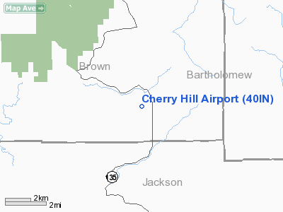
Location
& QuickFacts
|
FAA
Information Effective: |
2007-12-20 |
|
Airport
Identifier: |
40IN |
|
Airport
Status: |
Operational |
|
Longitude/Latitude: |
086-09-14.9550W/39-04-27.1820N
-86.154154/39.074217 (Estimated) |
|
Elevation: |
745 ft / 227.08 m (Estimated) |
|
Land: |
0 acres |
|
From nearest
city: |
6 nautical miles NW of Freetown, IN |
|
Location: |
Brown County, IN |
|
Magnetic
Variation: |
02W (1985) |
Owner
& Manager
|
Ownership: |
Privately
owned |
|
Owner: |
Orville L Toler |
|
Address: |
8375 Sr135 S Brown Co.
Freetown, IN 47235 |
|
Phone
number: |
812-988-7002 |
|
Manager: |
Orville L Toler |
|
Address: |
8375 Sr135 S Brown Co.
Freetown, IN 47235 |
|
Phone
number: |
812-988-7002 |
Airport Operations
and Facilities
|
Airport
Use: |
Private |
|
Wind indicator: |
No |
|
Segmented
Circle: |
No |
|
Control
Tower: |
No |
|
Landing
fee charge: |
No |
|
Sectional
chart: |
St Louis |
|
Region: |
AGL - Great Lakes |
|
Boundary
ARTCC: |
ZID - Indianapolis |
|
Tie-in
FSS: |
HUF - Terre Haute |
|
FSS on
Airport: |
No |
|
FSS Toll
Free: |
1-800-WX-BRIEF |
|
Runway Information
Runway 16/34
|
Dimension: |
2200 x 100 ft
/ 670.6 x 30.5 m |
|
Surface: |
TURF, |
|
|
Runway 16 |
Runway 34 |
|
Traffic
Pattern: |
Left |
Left |
|
Obstruction: |
16 ft plines |
40 ft trees |
|
Radio Navigation
Aids
|
ID |
Type |
Name |
Ch |
Freq |
Var |
Dist |
|
EQZ |
NDB |
Captain |
|
308.00 |
02W |
15.0 nm |
|
BFR |
NDB |
Bedford |
|
344.00 |
02W |
19.3 nm |
|
BM |
NDB |
Claye |
|
382.00 |
02W |
20.8 nm |
|
BA |
NDB |
Clifs |
|
410.00 |
03W |
21.6 nm |
|
OVO |
NDB |
North Vernon |
|
374.00 |
02W |
25.9 nm |
|
HFY |
NDB |
Greenwood |
|
398.00 |
02W |
33.7 nm |
|
RRJ |
NDB |
Oranj |
|
368.00 |
02W |
37.2 nm |
|
IMS |
NDB |
Madison |
|
404.00 |
03W |
37.5 nm |
|
HLB |
NDB |
Batesville |
|
254.00 |
02W |
44.9 nm |
|
TVX |
NDB |
Greencastle |
|
521.00 |
03W |
49.0 nm |
|
OOM |
VORTAC |
Hoosier |
039X |
110.20 |
02W |
21.8 nm |
|
SHB |
VORTAC |
Shelbyville |
057X |
112.00 |
01E |
36.9 nm |
|
ABB |
VORTAC |
Nabb |
071X |
112.40 |
01E |
37.9 nm |
|
VHP |
VORTAC |
Brickyard |
110X |
116.30 |
01E |
45.6 nm |
|
IND |
VOT |
Indianapolis Intl |
|
109.60 |
|
39.5 nm |
Based Aircraft
|
Aircraft
based on field: |
1 |
|
Single Engine
Airplanes: |
1 |
Cherry Hill Airport
Address:
Brown County, IN
Tel:
812-988-7002
Images
and information placed above are from
http://www.airport-data.com/airport/40IN/
We
thank them for the data!
| General
Info |
| Country |
United
States |
| State |
INDIANA
|
| FAA ID |
40IN |
| Latitude |
39-04-27.182N
|
| Longitude |
086-09-14.955W
|
| Elevation |
745 feet
|
| Near City |
FREETOWN
|
We don't guarantee the information is fresh and accurate. The data may
be wrong or outdated.
For more up-to-date information please refer to other sources.
|
|


