 |
|
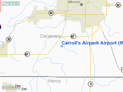
Carroll's Airpark Airport |
Location
& QuickFacts
|
FAA
Information Effective: |
2007-12-20 |
|
Airport
Identifier: |
IN56 |
|
Airport
Status: |
Operational |
|
Longitude/Latitude: |
085-25-55.0000W/40-07-37.0000N
-85.431944/40.126944 (Estimated) |
|
Elevation: |
940 ft / 286.51 m (Estimated) |
|
Land: |
5 acres |
|
From nearest
city: |
5 nautical miles SW of Muncie, IN |
|
Location: |
Delaware County, IN |
|
Magnetic
Variation: |
04W (2000) |
Owner
& Manager
|
Ownership: |
Privately
owned |
|
Owner: |
Calvin Carroll |
|
Address: |
3327
S. Madison St.
Muncie,
IN 47302 |
|
Phone
number: |
765-741-9048 |
|
Manager: |
Calvin Carroll |
|
Address: |
3327
S. Madison St.
Muncie,
IN 47302 |
|
Phone
number: |
765-741-9048 |
Airport Operations
and Facilities
|
Airport
Use: |
Private |
|
Wind indicator: |
Yes |
|
Segmented
Circle: |
No |
|
Control
Tower: |
No |
|
Sectional
chart: |
Chicago |
|
Region: |
AGL - Great Lakes |
|
Boundary
ARTCC: |
ZID - Indianapolis |
|
Tie-in
FSS: |
HUF - Terre Haute |
|
FSS Toll
Free: |
1-800-WX-BRIEF |
|
Runway Information
Runway 09/27
|
Dimension: |
2800 x 75 ft
/ 853.4 x 22.9 m |
|
Surface: |
TURF, |
|
|
Runway 09 |
Runway 27 |
|
Traffic
Pattern: |
Left |
Left |
|
Displaced
threshold: |
600.00 ft
RY 09 DSPLCD THLD MKD WITH CONES. |
0.00 ft |
|
Obstruction: |
25 ft pline |
|
|
Radio Navigation
Aids
|
ID |
Type |
Name |
Ch |
Freq |
Var |
Dist |
|
AI |
NDB |
Video |
|
371.00 |
03W |
5.0 nm |
|
UWL |
NDB |
New Castle |
|
385.00 |
02W |
15.7 nm |
|
PLD |
NDB |
Portland |
|
257.00 |
03W |
28.4 nm |
|
UMP |
NDB |
Metropolitan |
|
338.00 |
03W |
30.6 nm |
|
HZP |
NDB |
Zionsville |
|
248.00 |
03W |
39.3 nm |
|
IWH |
NDB |
Wabash |
|
329.00 |
03W |
41.8 nm |
|
VES |
NDB |
Versailles |
|
356.00 |
04W |
42.0 nm |
|
HFY |
NDB |
Greenwood |
|
398.00 |
02W |
42.5 nm |
|
HHG |
NDB |
Huntington |
|
417.00 |
03W |
43.8 nm |
|
CQA |
NDB |
Lakefield |
|
205.00 |
04W |
45.1 nm |
|
HLB |
NDB |
Batesville |
|
254.00 |
02W |
47.4 nm |
|
OXD |
NDB |
Oxford |
|
282.00 |
04W |
47.9 nm |
|
MIE |
VOR/DME |
Muncie |
091X |
114.40 |
03W |
6.9 nm |
|
MZZ |
VOR/DME |
Marion |
023X |
108.60 |
03W |
24.8 nm |
|
DQN |
VOR/DME |
Dayton |
092X |
114.50 |
01W |
48.1 nm |
|
SHB |
VORTAC |
Shelbyville |
057X |
112.00 |
01E |
34.8 nm |
|
RID |
VORTAC |
Richmond |
043X |
110.60 |
03W |
35.3 nm |
|
OKK |
VORTAC |
Kokomo |
082X |
113.50 |
00E |
37.5 nm |
|
GUS |
VORTAC |
Grissom |
21Y |
108.45 |
02W |
45.3 nm |
|
VHP |
VORTAC |
Brickyard |
110X |
116.30 |
01E |
47.0 nm |
|
IND |
VOT |
Indianapolis Intl |
|
109.60 |
|
46.1 nm |
Remarks
- PRVDD
CLEAR 20:1 APCHS AND CLEAR OBSTACLE FREE ZONE.
Based Aircraft
|
Aircraft
based on field: |
1 |
|
Single Engine
Airplanes: |
1 |
Carroll's Airpark Airport
Address:
Delaware County, IN
Tel:
765-741-9048
Images
and information placed above are from
http://www.airport-data.com/airport/IN56/
We
thank them for the data!
| General
Info |
| Country |
United
States |
| State |
INDIANA
|
| FAA ID |
IN56 |
| Latitude |
40-07-37.000N
|
| Longitude |
085-25-55.000W
|
| Elevation |
940 feet
|
| Near City |
MUNCIE
|
We don't guarantee the information is fresh and accurate. The data may
be wrong or outdated.
For more up-to-date information please refer to other sources.
|
|


