 |
|
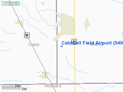
Location & QuickFacts
|
FAA
Information Effective: |
2007-12-20 |
|
Airport
Identifier: |
54II |
|
Airport
Status: |
Operational |
|
Longitude/Latitude: |
086-09-18.9760W/40-37-28.1420N
-86.155271/40.624484 (Estimated) |
|
Elevation: |
800 ft / 243.84 m (Estimated) |
|
Land: |
0 acres |
|
From nearest
city: |
4 nautical miles SW of Bunker Hill, IN |
|
Location: |
Miami County, IN |
|
Magnetic
Variation: |
02W (1985) |
Owner & Manager
|
Ownership: |
Privately
owned |
|
Owner: |
Mark Caldwell |
|
Address: |
Rr 1
Bunker Hill, IN 46914 |
|
Phone
number: |
219-699-7825 |
|
Manager: |
Mark Caldwell |
|
Address: |
Rr 1
Bunker Hill, IN 46914 |
Airport Operations
and Facilities
|
Airport
Use: |
Private |
|
Segmented
Circle: |
No |
|
Control
Tower: |
No |
|
Sectional
chart: |
Chicago |
|
Region: |
AGL - Great Lakes |
|
Boundary
ARTCC: |
ZAU - Chicago |
|
Tie-in
FSS: |
HUF - Terre Haute |
|
FSS Toll
Free: |
1-800-WX-BRIEF |
|
Runway Information
Runway 18/36
|
Dimension: |
2500 x 100 ft
/ 762.0 x 30.5 m |
|
Surface: |
TURF, |
|
|
Runway
18 |
Runway
36 |
|
Traffic
Pattern: |
Left |
Left |
|
Radio Navigation Aids
|
ID |
Type |
Name |
Ch |
Freq |
Var |
Dist |
|
GGP |
NDB |
Logansport |
|
263.00 |
01W |
11.2 nm |
|
IWH |
NDB |
Wabash |
|
329.00 |
03W |
18.3 nm |
|
RCR |
NDB |
Rochester |
|
216.00 |
03W |
26.5 nm |
|
MCX |
NDB |
White County |
|
377.00 |
03W |
28.1 nm |
|
FKR |
NDB |
Frankfort |
|
278.00 |
02W |
28.3 nm |
|
HHG |
NDB |
Huntington |
|
417.00 |
03W |
34.4 nm |
|
RWN |
NDB |
Winamac/dcmsnd |
|
335.00 |
00W |
34.8 nm |
|
CPB |
NDB |
Culver |
|
391.00 |
01W |
37.1 nm |
|
HZP |
NDB |
Zionsville |
|
248.00 |
03W |
41.4 nm |
|
UMP |
NDB |
Metropolitan |
|
338.00 |
03W |
41.6 nm |
|
AI |
NDB |
Video |
|
371.00 |
03W |
44.5 nm |
|
OLK |
VOR |
Wolf Lake |
|
110.40 |
03W |
47.9 nm |
|
MZZ |
VOR/DME |
Marion |
023X |
108.60 |
03W |
23.1 nm |
|
MIE |
VOR/DME |
Muncie |
091X |
114.40 |
03W |
41.9 nm |
|
OXI |
VOR/DME |
Knox |
103X |
115.60 |
00E |
47.5 nm |
|
GUS |
VORTAC |
Grissom |
21Y |
108.45 |
02W |
1.2 nm |
|
OKK |
VORTAC |
Kokomo |
082X |
113.50 |
00E |
7.3 nm |
|
BVT |
VORTAC |
Boiler |
098X |
115.10 |
01E |
41.9 nm |
|
FWA |
VORTAC |
Fort Wayne |
125X |
117.80 |
00E |
48.9 nm |
|
VHP |
VORTAC |
Brickyard |
110X |
116.30 |
01E |
49.6 nm |
|
FWA |
VOT |
Fort Wayne Baer |
|
111.00 |
|
48.7 nm |
Remarks
- OWNER
DESIRES ARPT NOT BE CHARTED.
- PROVIDED
LETTER OF AGREEMENT IS CURRENT & REMAINS IN EFFECT.
Based Aircraft
|
Aircraft
based on field: |
2 |
|
Single Engine
Airplanes: |
2 |
Caldwell Field Airport
Address:
Miami County, IN
Tel:
219-699-7825
Images
and information placed above are from
http://www.airport-data.com/airport/54II/
We
thank them for the data!
| General
Info |
| Country |
United
States |
| State |
INDIANA
|
| FAA ID |
54II |
| Latitude |
40-37-28.142N
|
| Longitude |
086-09-18.976W
|
| Elevation |
800 feet
|
| Near City |
BUNKER
HILL |
We don't guarantee the information is fresh and accurate. The data may
be wrong or outdated.
For more up-to-date information please refer to other sources.
|
|


