 |
|
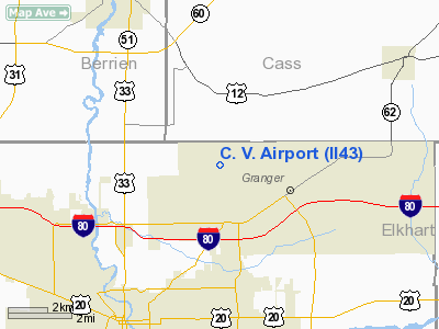
Location
& QuickFacts
|
FAA
Information Effective: |
2007-12-20 |
|
Airport
Identifier: |
II43 |
|
Airport
Status: |
Operational |
|
Longitude/Latitude: |
086-11-32.0200W/41-45-00.1730N
-86.192228/41.750048 (Estimated) |
|
Elevation: |
780 ft / 237.74 m (Estimated) |
|
Land: |
0 acres |
|
From nearest
city: |
4 nautical miles W of Granger, IN |
|
Location: |
St Joseph County, IN |
|
Magnetic
Variation: |
03W (1985) |
Owner & Manager
|
Ownership: |
Privately
owned |
|
Owner: |
Charles Verhostra |
|
Address: |
51375 Hickory Road
Granger,
IN 46530 |
|
Phone
number: |
219-272-0465 |
|
Address: |
|
Airport
Operations and Facilities
|
Airport
Use: |
Private |
|
Segmented
Circle: |
No |
|
Control
Tower: |
No |
|
Landing
fee charge: |
No |
|
Sectional
chart: |
Chicago |
|
Region: |
AGL - Great Lakes |
|
Boundary
ARTCC: |
ZAU - Chicago |
|
Tie-in
FSS: |
HUF - Terre Haute |
|
FSS Toll
Free: |
1-800-WX-BRIEF |
|
Runway Information
Runway NW/SE
|
Dimension: |
1200 x 100 ft
/ 365.8 x 30.5 m |
|
Surface: |
TURF, |
|
|
Runway NW |
Runway SE |
|
Traffic
Pattern: |
Left |
Left |
|
Radio Navigation
Aids
|
ID |
Type |
Name |
Ch |
Freq |
Var |
Dist |
|
MGC |
NDB |
Michigan City |
|
203.00 |
01W |
28.1 nm |
|
HAI |
NDB |
Three Rivers |
|
407.00 |
02W |
29.7 nm |
|
IUL |
NDB |
La Porte |
|
356.00 |
03W |
30.1 nm |
|
CPB |
NDB |
Culver |
|
391.00 |
01W |
33.2 nm |
|
IRS |
NDB |
Sturgis |
|
382.00 |
04W |
34.2 nm |
|
VP |
NDB |
Sedly |
|
212.00 |
02W |
35.7 nm |
|
RCR |
NDB |
Rochester |
|
216.00 |
03W |
41.2 nm |
|
RWN |
NDB |
Winamac/dcmsnd |
|
335.00 |
00W |
43.6 nm |
|
OLK |
VOR |
Wolf Lake |
|
110.40 |
03W |
43.5 nm |
|
ELX |
VOR/DME |
Keeler |
113X |
116.60 |
00E |
23.9 nm |
|
OXI |
VOR/DME |
Knox |
103X |
115.60 |
00E |
32.9 nm |
|
AZO |
VOR/DME |
Kalamazoo |
027X |
109.00 |
01W |
40.9 nm |
|
PMM |
VOR/DME |
Pullman |
058X |
112.10 |
00E |
43.2 nm |
|
GIJ |
VORTAC |
Gipper |
101X |
115.40 |
00E |
5.8 nm |
|
GSH |
VORTAC |
Goshen |
084X |
113.70 |
00E |
15.4 nm |
Remarks
- OWNER
DESIRES AIRPORT NOT TO BE CHARTED.
- FILED
FOR RECORD PURPOSES ONLY.
C. V. Airport
Address:
St Joseph County, IN
Tel:
219-272-0465
Images
and information placed above are from
http://www.airport-data.com/airport/II43/
We
thank them for the data!
| General
Info |
| Country |
United
States |
| State |
INDIANA
|
| FAA ID |
II43 |
| Latitude |
41-45-00.173N
|
| Longitude |
086-11-32.020W
|
| Elevation |
780 feet
|
| Near City |
GRANGER
|
We don't guarantee the information is fresh and accurate. The data may
be wrong or outdated.
For more up-to-date information please refer to other sources.
|
|


