 |
|
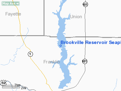
Brookville Reservoir Seaplane Base |
Location
& QuickFacts
|
FAA
Information Effective: |
2007-12-20 |
|
Airport
Identifier: |
12I |
|
Airport
Status: |
Operational |
|
Longitude/Latitude: |
084-59-59.8580W/39-30-37.1790N
-84.999961/39.510328 (Estimated) |
|
Elevation: |
748 ft / 227.99 m (Estimated) |
|
Land: |
5260 acres |
|
From nearest
city: |
6 nautical miles N of Brookville, IN |
|
Location: |
Franklin County, IN |
|
Magnetic
Variation: |
03W (1985) |
Owner
& Manager
|
Ownership: |
Publicly
owned |
|
Owner: |
Dept Of Natural Resources |
|
Address: |
P.o. Box 100
Brookville, IN 47012 |
|
Phone number: |
765-647-2657
EXT. 0 |
|
Manager: |
Bob Felix |
|
Address: |
P.o. Box 100
Brookville, IN 47012 |
|
Phone number: |
765-647-2657
EXT. 0 |
Airport
Operations and Facilities
|
Airport
Use: |
Open to
public |
|
Segmented
Circle: |
No |
|
Control
Tower: |
No |
|
Sectional
chart: |
Cincinnati |
|
Region: |
AGL - Great Lakes |
|
Boundary
ARTCC: |
ZID - Indianapolis |
|
Tie-in FSS: |
HUF - Terre Haute |
|
FSS on Airport: |
No |
|
FSS Toll
Free: |
1-800-WX-BRIEF |
|
NOTAMs Facility: |
HUF (NOTAM-d service avaliable) |
Airport
Communications
|
Runway
Information
Runway
18/36
|
Dimension: |
16000 x 2000 ft
/ 4876.8 x 609.6 m |
|
Surface: |
WATER,
|
|
|
Runway
18 |
Runway
36 |
|
Traffic Pattern: |
Left |
Left |
|
Runway
N/S
|
Dimension: |
25000 x 2000 ft
/ 7620.0 x 609.6 m |
|
Surface: |
WATER,
|
|
|
Runway
N |
Runway
S |
|
Traffic Pattern: |
Left |
Left |
|
Radio
Navigation Aids
|
ID |
Type |
Name |
Ch |
Freq |
Var |
Dist |
|
OXD |
NDB |
Oxford |
|
282.00 |
04W |
10.2
nm |
|
HLB |
NDB |
Batesville |
|
254.00 |
02W |
15.4
nm |
|
HAO |
NDB |
Hamilton |
|
260.00 |
04W |
21.5
nm |
|
HKF |
NDB |
Hook
Field |
|
239.00 |
04W |
25.6
nm |
|
UWL |
NDB |
New
Castle |
|
385.00 |
02W |
26.7
nm |
|
UR |
NDB |
Burln |
|
321.00 |
04W |
29.8
nm |
|
ISZ |
NDB |
Cincinnati-blue Ash |
|
388.00 |
04W |
32.4
nm |
|
MDE |
NDB |
Madeira |
|
379.00 |
04W |
34.6
nm |
|
LUK |
NDB |
Cincinnati |
|
335.00 |
04W |
37.2
nm |
|
OVO |
NDB |
North
Vernon |
|
374.00 |
02W |
39.4
nm |
|
BA |
NDB |
Clifs |
|
410.00 |
03W |
39.7
nm |
|
AI |
NDB |
Video |
|
371.00 |
03W |
41.1
nm |
|
PWF |
NDB |
Sportys |
|
245.00 |
04W |
44.8
nm |
|
VES |
NDB |
Versailles |
|
356.00 |
04W |
47.3
nm |
|
IMS |
NDB |
Madison |
|
404.00 |
03W |
49.9
nm |
|
FFO |
TACAN |
Patterson |
099X |
|
04W |
47.5
nm |
|
DQN |
VOR/DME |
Dayton |
092X |
114.50 |
01W |
41.3
nm |
|
MIE |
VOR/DME |
Muncie |
091X |
114.40 |
03W |
47.3
nm |
|
RID |
VORTAC |
Richmond |
043X |
110.60 |
03W |
16.5
nm |
|
CVG |
VORTAC |
Cincinnati |
120X |
117.30 |
04W |
32.8
nm |
|
SHB |
VORTAC |
Shelbyville |
057X |
112.00 |
01E |
38.9
nm |
|
LUK |
VOT |
Cincinnati Muni/lunken |
|
108.40 |
|
36.6
nm |
|
DAY |
VOT |
Dayton J M Cox-day |
|
111.00 |
|
43.1
nm |
Remarks
- 2
N/S RWYS: ONE 25000'S OF BRIDGE & ONE 16000'N OF BRIDGE AT MID-POINT
OF LAKE.
- SEAPLANE
OPNS PROHIBITED BTN SS-SR.
Operational Statistics
Time
Period: 2004-01-02 - 2004-12-31
|
Aircraft
Operations: |
1/Month |
|
General Aviation
Itinerant: |
100.0% |
Brookville Reservoir Seaplane Base
Address: Franklin
County, IN
Tel:
765-647-2657
Images
and information placed above are from
http://www.airport-data.com/airport/12I/
We
thank them for the data!
| General
Info |
| Country |
United
States |
| State |
INDIANA
|
| FAA ID |
12I |
| Latitude |
39-30-37.179N
|
| Longitude |
084-59-59.858W
|
| Elevation |
748 feet
|
| Near City |
BROOKVILLE
|
We don't guarantee the information is fresh and accurate. The data may
be wrong or outdated.
For more up-to-date information please refer to other sources.
|
|


