 |
|
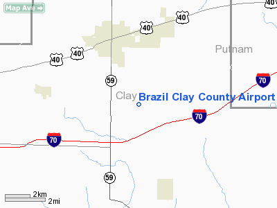
Brazil Clay County Airport |
|
|
Location
& QuickFacts
|
FAA
Information Effective: |
2007-12-20 |
|
Airport
Identifier: |
0I2 |
|
Airport
Status: |
Operational |
|
Longitude/Latitude: |
087-05-58.9530W/39-28-36.2480N
-87.099709/39.476736 (Estimated) |
|
Elevation: |
645 ft / 196.60 m (Surveyed) |
|
Land: |
70 acres |
|
From nearest
city: |
3 nautical miles S of Brazil, IN |
|
Location: |
Clay County, IN |
|
Magnetic
Variation: |
01W (1985) |
Owner
& Manager
|
Ownership: |
Publicly
owned |
|
Owner: |
Brazil-clay County Boac
MIKE KNUST PRESIDENT |
|
Address: |
Po Box 255
Brazil,
IN 47834 |
|
Phone
number: |
812-443-0018 |
|
Manager: |
Jack Thomas |
|
Address: |
Po Box 255
Brazil,
IN 47834 |
|
Phone
number: |
812-443-0018 |
Airport
Operations and Facilities
|
Airport
Use: |
Open
to public |
|
Wind indicator: |
Yes |
|
Segmented
Circle: |
No |
|
Control
Tower: |
No |
|
Lighting
Schedule: |
DUSK-DAWN |
|
Beacon
Color: |
Clear-Green (lighted land airport) |
|
Landing
fee charge: |
No |
|
Sectional
chart: |
St Louis |
|
Region: |
AGL - Great Lakes |
|
Boundary
ARTCC: |
ZID - Indianapolis |
|
Tie-in
FSS: |
HUF - Terre Haute |
|
FSS on
Airport: |
No |
|
FSS Toll
Free: |
1-800-WX-BRIEF |
|
NOTAMs
Facility: |
HUF (NOTAM-d service avaliable) |
Airport Communications
|
CTAF: |
122.800 |
|
Unicom: |
122.800
|
Airport Services
|
Fuel
available: |
100LL
FOR FUEL CALL 812-443-0018 |
|
Airframe
Repair: |
MAJOR |
|
Power
Plant Repair: |
MAJOR |
|
Bottled
Oxygen: |
NONE |
|
Bulk Oxygen: |
NONE |
|
Runway Information
Runway 09/27
|
Dimension: |
2941 x 40 ft
/ 896.4 x 12.2 m |
|
Surface: |
ASPH, Good Condition |
|
Weight Limit: |
Single wheel: 8000 lbs. |
|
Edge Lights: |
Low |
|
|
Runway 09 |
Runway 27 |
|
Longitude: |
087-06-17.7130W |
087-05-40.2100W |
|
Latitude: |
39-28-36.5450N |
39-28-35.9880N |
|
Elevation: |
645.00 ft |
631.00 ft |
|
Alignment: |
91 |
127 |
|
Traffic
Pattern: |
Left |
Left |
|
Markings: |
Basic, Good Condition |
Basic, Good Condition |
|
Displaced
threshold: |
620.00 ft |
442.00 ft |
|
Runway End
Identifier: |
No |
No |
|
Centerline
Lights: |
No |
No |
|
Touchdown
Lights: |
No |
No |
|
Obstruction: |
35 ft trees, 210.0 ft from runway
RWY 09 APCH RATIO 23:1 TO DSPLCD THLD.
RY
09 4 FT FENCE 28 FT FM RY END. |
55 ft trees, 201.0 ft from runway, 190 ft right
of centerline
APCH RATIO 11:1 TO DSPLCD THLD 55 FT TREES 643 FT E &
190 FT R OF THLD CNTRLN.
RY 27 15' TREES & BRUSH 55' R 11 FT FM RY END; APCH SLOPE
13:1 TO DSPLCD THR. |
|
Radio Navigation
Aids
|
ID |
Type |
Name |
Ch |
Freq |
Var |
Dist |
|
HU |
NDB |
Yinno |
|
245.00 |
02W |
14.8 nm |
|
TVX |
NDB |
Greencastle |
|
521.00 |
03W |
19.7 nm |
|
SIV |
NDB |
Sullivan |
|
326.00 |
02W |
27.2 nm |
|
PRG |
NDB |
Paris |
|
341.00 |
01E |
29.8 nm |
|
CFJ |
NDB |
Crawfordsville |
|
388.00 |
02W |
31.5 nm |
|
BM |
NDB |
Claye |
|
382.00 |
02W |
34.4 nm |
|
PLX |
NDB |
Palestine |
|
391.00 |
00W |
37.6 nm |
|
CZB |
NDB |
Casey |
|
359.00 |
00E |
43.2 nm |
|
DCY |
NDB |
Washington |
|
212.00 |
03W |
46.9 nm |
|
HFY |
NDB |
Greenwood |
|
398.00 |
02W |
47.7 nm |
|
HZP |
NDB |
Zionsville |
|
248.00 |
03W |
48.2 nm |
|
BFR |
NDB |
Bedford |
|
344.00 |
02W |
49.2 nm |
|
MT |
NDB |
Zebre |
|
347.00 |
00E |
49.9 nm |
|
RSV |
VOR/DME |
Robinson |
021X |
108.40 |
02E |
37.6 nm |
|
LWV |
VOR/DME |
Lawrenceville |
025X |
108.80 |
01W |
48.6 nm |
|
TTH |
VORTAC |
Terre Haute |
100X |
115.30 |
02E |
7.0 nm |
|
OOM |
VORTAC |
Hoosier |
039X |
110.20 |
02W |
30.2 nm |
|
VHP |
VORTAC |
Brickyard |
110X |
116.30 |
01E |
39.5 nm |
|
IND |
VOT |
Indianapolis Intl |
|
109.60 |
|
40.6 nm |
Remarks
- +80'
WSW - ENE PLINE 4/5 MI N OF ARPT.
- LARGE
FLOCKS OF GEESE ON & INVOF ARPT.
- RWY
09/27 IREG 20' DEPRESSION E OF RWY 27 END AND 100' N OF CL.
- RESTRICTED
TO VFR
Based Aircraft
|
Aircraft
based on field: |
15 |
|
Single Engine
Airplanes: |
14 |
|
Helicopters: |
1 |
Operational Statistics
Time
Period: 2004-01-02 - 2004-12-31
|
Aircraft
Operations: |
179/Week |
|
Air Taxi: |
1.8% |
|
General Aviation
Local: |
45.9% |
|
General Aviation
Itinerant: |
52.3% |
Brazil Clay County Airport
Address:
Clay County, IN
Tel:
812-443-0018
Images
and information placed above are from
http://www.airport-data.com/airport/0I2/
We
thank them for the data!
| General
Info |
| Country |
United
States |
| State |
INDIANA
|
| FAA ID |
0I2 |
| Latitude |
39-28-36.248N
|
| Longitude |
087-05-58.953W
|
| Elevation |
645 feet
|
| Near City |
BRAZIL
|
We don't guarantee the information is fresh and accurate. The data may
be wrong or outdated.
For more up-to-date information please refer to other sources.
|
|


