 |
|
|
|
|
|
Location
& QuickFacts
|
FAA
Information Effective: |
2007-12-20 |
|
Airport
Identifier: |
IN70 |
|
Airport
Status: |
Operational |
|
Longitude/Latitude: |
087-01-37.1150W/41-38-01.1370N
-87.026976/41.633649 (Estimated) |
|
Elevation: |
675 ft / 205.74 m (Estimated) |
|
Land: |
79 acres |
|
From nearest
city: |
3 nautical miles NE of Chesterton, IN |
|
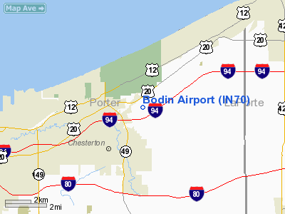
Location: |
Porter County, IN |
|
Magnetic
Variation: |
02W (1985) |
Owner & Manager
|
Ownership: |
Privately
owned |
|
Owner: |
Life Estate Ownership |
|
Address: |
Po Box 991
Chesterton,
IN 46304 |
|
Phone
number: |
219-926-1708 |
|
Manager: |
Walter B Cox |
|
Address: |
Po Box 991
Chesterton,
IN 46304 |
|
Phone
number: |
219-926-1708 |
Airport
Operations and Facilities
|
Airport
Use: |
Private |
|
Wind indicator: |
Yes |
|
Segmented
Circle: |
No |
|
Control
Tower: |
No |
|
Lighting
Schedule: |
PHONE REQ
FOR MIRL RY 18/36 PHONE 219-926-1708. |
|
Landing
fee charge: |
No |
|
Sectional
chart: |
Chicago |
|
Region: |
AGL - Great Lakes |
|
Boundary
ARTCC: |
ZAU - Chicago |
|
Tie-in
FSS: |
HUF - Terre Haute |
|
FSS on
Airport: |
No |
|
FSS Toll
Free: |
1-800-WX-BRIEF |
Airport Services
|
Airframe
Repair: |
NONE |
|
Power
Plant Repair: |
NONE |
|
Runway Information
Runway 18/36
|
Dimension: |
2400 x 75 ft
/ 731.5 x 22.9 m |
|
Surface: |
TURF, |
|
Edge Lights: |
Medium |
|
|
Runway 18 |
Runway 36 |
|
Traffic
Pattern: |
Left |
Left |
|
Obstruction: |
30 ft pline, 200.0 ft from runway |
|
|
Radio Navigation
Aids
|
ID |
Type |
Name |
Ch |
Freq |
Var |
Dist |
|
MGC |
NDB |
Michigan City |
|
203.00 |
01W |
10.4 nm |
|
VP |
NDB |
Sedly |
|
212.00 |
02W |
12.9 nm |
|
IUL |
NDB |
La Porte |
|
356.00 |
03W |
14.1 nm |
|
MX |
NDB |
Kedzi |
|
248.00 |
01W |
30.4 nm |
|
HK |
NDB |
Ermin |
|
332.00 |
01W |
36.7 nm |
|
RWN |
NDB |
Winamac/dcmsnd |
|
335.00 |
00W |
37.6 nm |
|
CPB |
NDB |
Culver |
|
391.00 |
01W |
38.3 nm |
|
RZL |
NDB |
Rensselaer |
|
362.00 |
02W |
41.9 nm |
|
ME |
NDB |
Deana |
|
350.00 |
00E |
49.1 nm |
|
OXI |
VOR/DME |
Knox |
103X |
115.60 |
00E |
25.3 nm |
|
ORD |
VOR/DME |
Chicago O'hare |
086X |
113.90 |
02E |
44.7 nm |
|
CGT |
VORTAC |
Chicago Heights |
089X |
114.20 |
02E |
25.6 nm |
|
GIJ |
VORTAC |
Gipper |
101X |
115.40 |
00E |
32.8 nm |
|
EON |
VORTAC |
Peotone |
079X |
113.20 |
02E |
40.8 nm |
|
GSH |
VORTAC |
Goshen |
084X |
113.70 |
00E |
45.4 nm |
|
MDW |
VOT |
Chicago Midway |
|
111.00 |
|
33.8 nm |
|
ORD |
VOT |
Chicago O'hare Intl |
|
112.00 |
|
44.7 nm |
Remarks
Based Aircraft
|
Aircraft
based on field: |
5 |
|
Single Engine
Airplanes: |
4 |
|
Ultralights: |
1 |
Bodin Airport
Address:
Porter County, IN
Tel:
219-926-1708
Images
and information placed above are from
http://www.airport-data.com/airport/IN70/
We
thank them for the data!
| General
Info |
| Country |
United
States |
| State |
INDIANA
|
| FAA ID |
IN70 |
| Latitude |
41-38-01.137N
|
| Longitude |
087-01-37.115W
|
| Elevation |
675 feet
|
| Near City |
CHESTERTON
|
We don't guarantee the information is fresh and accurate. The data may
be wrong or outdated.
For more up-to-date information please refer to other sources.
|
|


