 |
|
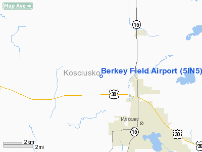
Location
& QuickFacts
|
FAA
Information Effective: |
2007-12-20 |
|
Airport
Identifier: |
5IN5 |
|
Airport
Status: |
Operational |
|
Longitude/Latitude: |
085-54-02.0000W/41-17-16.0000N
-85.900556/41.287778 (Estimated) |
|
Elevation: |
858 ft / 261.52 m (Estimated) |
|
Land: |
0 acres |
|
From nearest
city: |
4 nautical miles NW of Warsaw, IN |
|
Location: |
Kosciusko County, IN |
|
Magnetic
Variation: |
05W (1965) |
Owner & Manager
|
Ownership: |
Privately
owned |
|
Owner: |
Earl L Berkey |
|
Address: |
3890 N 300 W
Warsaw, IN 46580 |
|
Phone
number: |
219-858-9850 |
|
Manager: |
Gary W Berkey |
|
Address: |
3642, 3642 N 300 W
Warsaw, IN 46580 |
|
Phone
number: |
219-858-9850 |
Airport
Operations and Facilities
|
Airport
Use: |
Private |
|
Segmented
Circle: |
No |
|
Control
Tower: |
No |
|
Sectional
chart: |
Chicago |
|
Region: |
AGL - Great Lakes |
|
Boundary
ARTCC: |
ZAU - Chicago |
|
Tie-in
FSS: |
HUF - Terre Haute |
|
FSS Toll
Free: |
1-800-WX-BRIEF |
|
Runway Information
Runway 18/36
|
Dimension: |
1190 x 100 ft
/ 362.7 x 30.5 m |
|
Surface: |
TURF, |
|
|
Runway 18 |
Runway 36 |
|
Traffic
Pattern: |
Left |
Right |
|
Obstruction: |
25 ft pline, 540.0 ft from runway |
|
|
Radio Navigation
Aids
|
ID |
Type |
Name |
Ch |
Freq |
Var |
Dist |
|
RCR |
NDB |
Rochester |
|
216.00 |
03W |
18.7 nm |
|
CPB |
NDB |
Culver |
|
391.00 |
01W |
22.3 nm |
|
IWH |
NDB |
Wabash |
|
329.00 |
03W |
31.8 nm |
|
HHG |
NDB |
Huntington |
|
417.00 |
03W |
32.6 nm |
|
RWN |
NDB |
Winamac/dcmsnd |
|
335.00 |
00W |
33.9 nm |
|
IRS |
NDB |
Sturgis |
|
382.00 |
04W |
37.9 nm |
|
GGP |
NDB |
Logansport |
|
263.00 |
01W |
40.9 nm |
|
IUL |
NDB |
La Porte |
|
356.00 |
03W |
41.3 nm |
|
ANQ |
NDB |
Angola |
|
347.00 |
05W |
42.3 nm |
|
HAI |
NDB |
Three Rivers |
|
407.00 |
02W |
42.6 nm |
|
VP |
NDB |
Sedly |
|
212.00 |
02W |
45.2 nm |
|
MGC |
NDB |
Michigan City |
|
203.00 |
01W |
48.3 nm |
|
OLK |
VOR |
Wolf Lake |
|
110.40 |
03W |
18.4 nm |
|
OXI |
VOR/DME |
Knox |
103X |
115.60 |
00E |
33.9 nm |
|
MZZ |
VOR/DME |
Marion |
023X |
108.60 |
03W |
48.8 nm |
|
GSH |
VORTAC |
Goshen |
084X |
113.70 |
00E |
15.4 nm |
|
GIJ |
VORTAC |
Gipper |
101X |
115.40 |
00E |
34.5 nm |
|
FWA |
VORTAC |
Fort Wayne |
125X |
117.80 |
00E |
37.2 nm |
|
GUS |
VORTAC |
Grissom |
21Y |
108.45 |
02W |
40.3 nm |
|
OKK |
VORTAC |
Kokomo |
082X |
113.50 |
00E |
46.2 nm |
|
FWA |
VOT |
Fort Wayne Baer |
|
111.00 |
|
37.1 nm |
Remarks
- 300
FT ANT 2.5 MILES SE OF ARPT, 25 FT POWERLINES 412 FT W OF RY & 50
FT TREES 130 FT E OF RY.
- PRVDD
400 FT TPA, CLEAR 20:1 APCH SLOPE, CLEAR OBSTACLE FREE AONE & CLEAR
RY SAFETY AREA.
Berkey Field Airport
Address:
Kosciusko County, IN
Tel:
219-858-9850
Images
and information placed above are from
http://www.airport-data.com/airport/5IN5/
We
thank them for the data!
| General
Info |
| Country |
United
States |
| State |
INDIANA
|
| FAA ID |
5IN5 |
| Latitude |
41-17-16.000N
|
| Longitude |
085-54-02.000W
|
| Elevation |
858 feet
|
| Near City |
WARSAW
|
We don't guarantee the information is fresh and accurate. The data may
be wrong or outdated.
For more up-to-date information please refer to other sources.
|
|


