 |
|
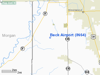
Location
& QuickFacts
|
FAA
Information Effective: |
2007-12-20 |
|
Airport
Identifier: |
IN64 |
|
Airport
Status: |
Operational |
|
Longitude/Latitude: |
086-12-14.3070W/39-33-39.1570N
-86.203974/39.560877 (Estimated) |
|
Elevation: |
800 ft / 243.84 m (Estimated) |
|
Land: |
0 acres |
|
From nearest
city: |
4 nautical miles NW of Bargersville, IN |
|
Location: |
Johnson County, IN |
|
Magnetic
Variation: |
00E (1990) |
Owner
& Manager
|
Ownership: |
Privately
owned |
|
Owner: |
Rex E Beck |
|
Address: |
4000 S Morgantown Rd
Greenwood,
IN 46143 |
|
Phone
number: |
317-242-3916 |
|
Address: |
|
Airport Operations
and Facilities
|
Airport
Use: |
Private |
|
Segmented
Circle: |
No |
|
Control
Tower: |
No |
|
Sectional
chart: |
St Louis |
|
Region: |
AGL - Great Lakes |
|
Boundary
ARTCC: |
ZID - Indianapolis |
|
Tie-in
FSS: |
HUF - Terre Haute |
|
FSS Toll
Free: |
1-800-WX-BRIEF |
|
Runway Information
Runway 09/27
|
Dimension: |
1000 x 150 ft
/ 304.8 x 45.7 m |
|
Surface: |
TURF, |
|
|
Runway 09 |
Runway 27 |
|
Traffic
Pattern: |
Left |
Left |
|
Obstruction: |
30 ft trees, 500.0 ft from runway |
30 ft trees, 500.0 ft from runway |
|
Radio Navigation
Aids
|
ID |
Type |
Name |
Ch |
Freq |
Var |
Dist |
|
HFY |
NDB |
Greenwood |
|
398.00 |
02W |
6.8 nm |
|
HZP |
NDB |
Zionsville |
|
248.00 |
03W |
22.9 nm |
|
BA |
NDB |
Clifs |
|
410.00 |
03W |
22.9 nm |
|
UMP |
NDB |
Metropolitan |
|
338.00 |
03W |
23.7 nm |
|
TVX |
NDB |
Greencastle |
|
521.00 |
03W |
29.4 nm |
|
BM |
NDB |
Claye |
|
382.00 |
02W |
35.5 nm |
|
CFJ |
NDB |
Crawfordsville |
|
388.00 |
02W |
41.5 nm |
|
OVO |
NDB |
North Vernon |
|
374.00 |
02W |
41.6 nm |
|
EQZ |
NDB |
Captain |
|
308.00 |
02W |
43.0 nm |
|
AI |
NDB |
Video |
|
371.00 |
03W |
44.3 nm |
|
BFR |
NDB |
Bedford |
|
344.00 |
02W |
44.7 nm |
|
UWL |
NDB |
New Castle |
|
385.00 |
02W |
45.2 nm |
|
HLB |
NDB |
Batesville |
|
254.00 |
02W |
45.7 nm |
|
FKR |
NDB |
Frankfort |
|
278.00 |
02W |
45.7 nm |
|
VHP |
VORTAC |
Brickyard |
110X |
116.30 |
01E |
17.0 nm |
|
SHB |
VORTAC |
Shelbyville |
057X |
112.00 |
01E |
18.1 nm |
|
OOM |
VORTAC |
Hoosier |
039X |
110.20 |
02W |
31.5 nm |
|
TTH |
VORTAC |
Terre Haute |
100X |
115.30 |
02E |
48.6 nm |
|
IND |
VOT |
Indianapolis Intl |
|
109.60 |
|
10.5 nm |
Remarks
- CLEAR
125' EITHER SIDE CNTRLN & 200' END OF RY; OBS REMOVED/LOWERED OR
THR DSPLCD TO PRVD 20:1 SLOPE.
Based Aircraft
|
Aircraft
based on field: |
1 |
|
Single Engine
Airplanes: |
1 |
Beck Airport
Address:
Johnson County, IN
Tel:
317-242-3916
Images
and information placed above are from
http://www.airport-data.com/airport/IN64/
We
thank them for the data!
| General
Info |
| Country |
United
States |
| State |
INDIANA
|
| FAA ID |
IN64 |
| Latitude |
39-33-39.157N
|
| Longitude |
086-12-14.307W
|
| Elevation |
800 feet
|
| Near City |
BARGERSVILLE
|
We don't guarantee the information is fresh and accurate. The data may
be wrong or outdated.
For more up-to-date information please refer to other sources.
|
|


