 |
|
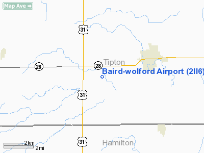
Location
& QuickFacts
|
FAA
Information Effective: |
2007-12-20 |
|
Airport
Identifier: |
2II6 |
|
Airport
Status: |
Operational |
|
Longitude/Latitude: |
086-06-09.9610W/40-15-53.1330N
-86.102767/40.264759 (Estimated) |
|
Elevation: |
880 ft / 268.22 m (Estimated) |
|
Land: |
0 acres |
|
From nearest
city: |
3 nautical miles SW of Tipton, IN |
|
Location: |
Tipton County, IN |
|
Magnetic
Variation: |
02W (1985) |
Owner & Manager
|
Ownership: |
Privately
owned |
|
Owner: |
William Wolford/allen Baird |
|
Address: |
|
|
Phone
number: |
317-675-7382 |
|
Manager: |
Mike Wolford |
|
Address: |
2761s-500w
Tipton, IN 46072-8996 |
|
Phone
number: |
317-675-8618 |
Airport
Operations and Facilities
|
Airport
Use: |
Private |
|
Wind indicator: |
Yes |
|
Segmented
Circle: |
No |
|
Control
Tower: |
No |
|
Sectional
chart: |
Chicago |
|
Region: |
AGL - Great Lakes |
|
Boundary
ARTCC: |
ZAU - Chicago |
|
Tie-in
FSS: |
HUF - Terre Haute |
|
FSS on
Airport: |
No |
|
FSS Toll
Free: |
1-800-WX-BRIEF |
|
Runway Information
Runway E/W
|
Dimension: |
2085 x 75 ft
/ 635.5 x 22.9 m
HAS A 170' STWY ON E END. |
|
Surface: |
TURF, |
|
|
Runway E |
Runway W |
|
Traffic
Pattern: |
Left |
Left |
|
Obstruction: |
25 ft pline, 200.0 ft from runway |
85 ft pline, 2000.0 ft from runway |
|
Radio Navigation
Aids
|
ID |
Type |
Name |
Ch |
Freq |
Var |
Dist |
|
UMP |
NDB |
Metropolitan |
|
338.00 |
03W |
19.8 nm |
|
HZP |
NDB |
Zionsville |
|
248.00 |
03W |
20.7 nm |
|
FKR |
NDB |
Frankfort |
|
278.00 |
02W |
21.1 nm |
|
GGP |
NDB |
Logansport |
|
263.00 |
01W |
29.4 nm |
|
AI |
NDB |
Video |
|
371.00 |
03W |
29.6 nm |
|
IWH |
NDB |
Wabash |
|
329.00 |
03W |
33.1 nm |
|
HFY |
NDB |
Greenwood |
|
398.00 |
02W |
38.0 nm |
|
MCX |
NDB |
White County |
|
377.00 |
03W |
40.3 nm |
|
CFJ |
NDB |
Crawfordsville |
|
388.00 |
02W |
41.1 nm |
|
UWL |
NDB |
New Castle |
|
385.00 |
02W |
42.8 nm |
|
HHG |
NDB |
Huntington |
|
417.00 |
03W |
46.0 nm |
|
TVX |
NDB |
Greencastle |
|
521.00 |
03W |
46.3 nm |
|
RCR |
NDB |
Rochester |
|
216.00 |
03W |
48.3 nm |
|
MZZ |
VOR/DME |
Marion |
023X |
108.60 |
03W |
23.8 nm |
|
MIE |
VOR/DME |
Muncie |
091X |
114.40 |
03W |
32.6 nm |
|
OKK |
VORTAC |
Kokomo |
082X |
113.50 |
00E |
15.9 nm |
|
GUS |
VORTAC |
Grissom |
21Y |
108.45 |
02W |
23.0 nm |
|
VHP |
VORTAC |
Brickyard |
110X |
116.30 |
01E |
29.7 nm |
|
SHB |
VORTAC |
Shelbyville |
057X |
112.00 |
01E |
40.1 nm |
|
BVT |
VORTAC |
Boiler |
098X |
115.10 |
01E |
47.6 nm |
|
IND |
VOT |
Indianapolis Intl |
|
109.60 |
|
33.5 nm |
Remarks
- LIGHT
BALLOON AND ULTRALIGHT ACTIVITY DURING MILD WX MONTHS.
- PROVIDED
THE 250' PRIMARY SUFACE IS CLEAR OF OBSTRUCTIONS.
Based Aircraft
|
Aircraft
based on field: |
2 |
|
Single Engine
Airplanes: |
2 |
Baird-wolford Airport
Address:
Tipton County, IN
Tel:
317-675-7382,
317-675-8618
Images
and information placed above are from
http://www.airport-data.com/airport/2II6/
We
thank them for the data!
| General
Info |
| Country |
United
States |
| State |
INDIANA
|
| FAA ID |
2II6 |
| Latitude |
40-15-53.133N
|
| Longitude |
086-06-09.961W
|
| Elevation |
880 feet
|
| Near City |
TIPTON
|
We don't guarantee the information is fresh and accurate. The data may
be wrong or outdated.
For more up-to-date information please refer to other sources.
|
|


