 |
|
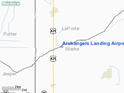
Archangels Landing Airport |
Location
& QuickFacts
|
FAA
Information Effective: |
2007-12-20 |
|
Airport
Identifier: |
IN26 |
|
Airport
Status: |
Operational |
|
Longitude/Latitude: |
086-52-21.0730W/41-15-41.1430N
-86.872520/41.261429 (Estimated) |
|
Elevation: |
669 ft / 203.91 m (Surveyed) |
|
Land: |
0 acres |
|
From nearest
city: |
4 nautical miles N of San Pierre, IN |
|
Location: |
Starke County, IN |
|
Magnetic
Variation: |
02W (1985) |
Owner
& Manager
|
Ownership: |
Privately
owned |
|
Owner: |
Michael Anthony Kielas |
|
Address: |
3003 South 900 West
San Pierre, IN 46374 |
|
Phone
number: |
219-896-3003 |
|
Manager: |
Michael Anthony Kielas |
|
Address: |
3003 South 900 West
San Pierre, IN 46374 |
|
Phone
number: |
219-896-2642 |
Airport Operations
and Facilities
|
Airport
Use: |
Private |
|
Wind indicator: |
Yes |
|
Segmented
Circle: |
No |
|
Control
Tower: |
No |
|
Sectional
chart: |
Chicago |
|
Region: |
AGL - Great Lakes |
|
Boundary
ARTCC: |
ZAU - Chicago |
|
Tie-in
FSS: |
HUF - Terre Haute |
|
FSS on
Airport: |
No |
|
FSS Toll
Free: |
1-800-WX-BRIEF |
|
Runway Information
Runway 01/19
|
Dimension: |
1800 x 150 ft
/ 548.6 x 45.7 m |
|
Surface: |
TURF, |
|
|
Runway 01 |
Runway 19 |
|
Traffic
Pattern: |
Left |
Left |
|
Obstruction: |
45 ft trees, 500.0 ft from runway |
45 ft trees, 250.0 ft from runway |
|
Radio Navigation
Aids
|
ID |
Type |
Name |
Ch |
Freq |
Var |
Dist |
|
VP |
NDB |
Sedly |
|
212.00 |
02W |
11.4 nm |
|
IUL |
NDB |
La Porte |
|
356.00 |
03W |
15.0 nm |
|
RWN |
NDB |
Winamac/dcmsnd |
|
335.00 |
00W |
15.8 nm |
|
CPB |
NDB |
Culver |
|
391.00 |
01W |
22.2 nm |
|
RZL |
NDB |
Rensselaer |
|
362.00 |
02W |
23.6 nm |
|
MGC |
NDB |
Michigan City |
|
203.00 |
01W |
26.9 nm |
|
RCR |
NDB |
Rochester |
|
216.00 |
03W |
33.1 nm |
|
MCX |
NDB |
White County |
|
377.00 |
03W |
33.5 nm |
|
GGP |
NDB |
Logansport |
|
263.00 |
01W |
40.2 nm |
|
MX |
NDB |
Kedzi |
|
248.00 |
01W |
46.8 nm |
|
OXI |
VOR/DME |
Knox |
103X |
115.60 |
00E |
10.7 nm |
|
IKK |
VOR/DME |
Kankakee |
053X |
111.60 |
00E |
45.6 nm |
|
CGT |
VORTAC |
Chicago Heights |
089X |
114.20 |
02E |
34.9 nm |
|
GIJ |
VORTAC |
Gipper |
101X |
115.40 |
00E |
39.4 nm |
|
GSH |
VORTAC |
Goshen |
084X |
113.70 |
00E |
41.3 nm |
|
EON |
VORTAC |
Peotone |
079X |
113.20 |
02E |
41.5 nm |
|
BVT |
VORTAC |
Boiler |
098X |
115.10 |
01E |
43.3 nm |
|
GUS |
VORTAC |
Grissom |
21Y |
108.45 |
02W |
49.4 nm |
Remarks
Based Aircraft
|
Aircraft
based on field: |
1 |
|
Single Engine
Airplanes: |
1 |
Archangels Landing Airport
Address:
Starke County, IN
Tel:
219-896-3003,
219-896-2642
Images
and information placed above are from
http://www.airport-data.com/airport/IN26/
We
thank them for the data!
| General
Info |
| Country |
United
States |
| State |
INDIANA
|
| FAA ID |
IN26 |
| Latitude |
41-15-41.143N
|
| Longitude |
086-52-21.073W
|
| Elevation |
669 feet
|
| Near City |
SAN PIERRE
|
We don't guarantee the information is fresh and accurate. The data may
be wrong or outdated.
For more up-to-date information please refer to other sources.
|
|


