|
|
|
 |
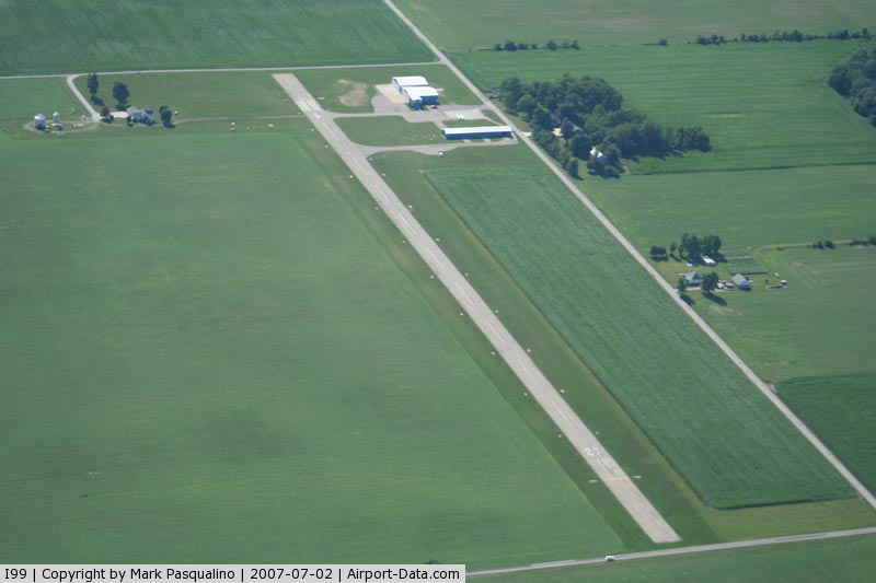
(Click on the photo to enlarge) |
Location
& QuickFacts
|
FAA
Information Effective: |
2007-12-20 |
|
Airport
Identifier: |
I99 |
|
Airport
Status: |
Operational |
|
Longitude/Latitude: |
085-38-15.1100W/40-13-57.0480N
-85.637531/40.232513 (Estimated) |
|
Elevation: |
900 ft / 274.32 m (Surveyed) |
|
Land: |
22 acres |
|
From nearest
city: |
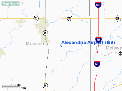
3 nautical miles SE of Alexandria, IN |
|
Location: |
Madison County, IN |
|
Magnetic
Variation: |
03W (1985) |
Owner & Manager
|
Ownership: |
Privately
owned |
|
Owner: |
Knotts Flying Service |
|
Address: |
1577 E. 900 N.
Alexandria, IN 46001 |
|
Phone
number: |
765-724-7060 |
|
Manager: |
Duane Knotts |
|
Address: |
1577 E. 900 N.
Alexandria, IN 46001 |
|
Phone
number: |
765-724-7060 |
Airport
Operations and Facilities
|
Airport
Use: |
Open
to public |
|
Wind indicator: |
Yes |
|
Segmented
Circle: |
No |
|
Control
Tower: |
No |
|
Lighting
Schedule: |
PHONE REQ
FOR ROTG BCN & MIRL RY 09/27 CALL 765-724-7060. |
|
Beacon
Color: |
Clear-Green (lighted land airport)
ROTG BCN OTS INDEFLY. |
|
Landing
fee charge: |
No |
|
Sectional
chart: |
Chicago |
|
Region: |
AGL - Great Lakes |
|
Boundary
ARTCC: |
ZID - Indianapolis |
|
Tie-in
FSS: |
HUF - Terre Haute |
|
FSS on
Airport: |
No |
|
FSS Toll
Free: |
1-800-WX-BRIEF |
|
NOTAMs
Facility: |
HUF (NOTAM-d service avaliable) |
Airport Communications
|
CTAF: |
122.800 |
|
Unicom: |
122.800
|
Airport Services
|
Fuel
available: |
100LL |
|
Airframe
Repair: |
MINOR |
|
Power
Plant Repair: |
MINOR |
|
Bottled
Oxygen: |
HIGH |
|
Bulk Oxygen: |
NONE |
|
Runway Information
Runway 09/27
|
Dimension: |
2591 x 60 ft
/ 789.7 x 18.3 m |
|
Surface: |
ASPH, Poor Condition
GRASS GROWING THROUGH NUMEROUS CRACKS. |
|
Edge Lights: |
Medium |
|
|
Runway 09 |
Runway 27 |
|
Longitude: |
085-38-31.7850W |
085-37-58.3840W |
|
Latitude: |
40-13-57.2500N |
40-13-56.7660N |
|
Elevation: |
894.00 ft |
885.00 ft |
|
Alignment: |
91 |
127 |
|
Traffic
Pattern: |
Left |
Left |
|
Markings: |
Nonstandard, Fair Condition
09/27 NON-STD NUMBER SIZE. |
Nonstandard, Fair Condition |
|
Displaced
threshold: |
195.00 ft |
270.00 ft |
|
Runway End
Identifier: |
No |
No |
|
Centerline
Lights: |
No |
No |
|
Touchdown
Lights: |
No |
No |
|
Obstruction: |
10 ft crops, 201.0 ft from runway
APCH RATIO 24:1 AT DSPLCD THR. DUE TO 10 FT ROAD 45 FT FM
RY END.
10 FT ROAD 45 FT FROM RWY END & CROPS 55-200 FT FROM RWY
END. |
10 ft crops, 201.0 ft from runway
APCH RATIO 20:1 AT DSPLCD THLD. DUE TO 15 FT ROAD 30 FT FM
RY END.
15 FT ROAD 30 FT FROM RWY END & CROPS 50-200 FT FROM RWY
END. |
|
Radio Navigation
Aids
|
ID |
Type |
Name |
Ch |
Freq |
Var |
Dist |
|
AI |
NDB |
Video |
|
371.00 |
03W |
11.4 nm |
|
UWL |
NDB |
New Castle |
|
385.00 |
02W |
25.8 nm |
|
UMP |
NDB |
Metropolitan |
|
338.00 |
03W |
26.0 nm |
|
IWH |
NDB |
Wabash |
|
329.00 |
03W |
32.8 nm |
|
PLD |
NDB |
Portland |
|
257.00 |
03W |
32.8 nm |
|
HZP |
NDB |
Zionsville |
|
248.00 |
03W |
33.2 nm |
|
HHG |
NDB |
Huntington |
|
417.00 |
03W |
38.3 nm |
|
HFY |
NDB |
Greenwood |
|
398.00 |
02W |
41.7 nm |
|
FKR |
NDB |
Frankfort |
|
278.00 |
02W |
42.5 nm |
|
GGP |
NDB |
Logansport |
|
263.00 |
01W |
44.2 nm |
|
MIE |
VOR/DME |
Muncie |
091X |
114.40 |
03W |
11.2 nm |
|
MZZ |
VOR/DME |
Marion |
023X |
108.60 |
03W |
15.8 nm |
|
OKK |
VORTAC |
Kokomo |
082X |
113.50 |
00E |
26.2 nm |
|
GUS |
VORTAC |
Grissom |
21Y |
108.45 |
02W |
34.2 nm |
|
SHB |
VORTAC |
Shelbyville |
057X |
112.00 |
01E |
37.1 nm |
|
VHP |
VORTAC |
Brickyard |
110X |
116.30 |
01E |
42.0 nm |
|
RID |
VORTAC |
Richmond |
043X |
110.60 |
03W |
46.7 nm |
|
FWA |
VORTAC |
Fort Wayne |
125X |
117.80 |
00E |
49.3 nm |
|
IND |
VOT |
Indianapolis Intl |
|
109.60 |
|
42.6 nm |
|
FWA |
VOT |
Fort Wayne Baer |
|
111.00 |
|
49.2 nm |
Remarks
- CROPS
100 FT EACH SIDE OF THE RY CNTRLN VIOLATE PRIM SFC.
- FREQUENT
GLIDER TFC ON WKENDS.
- EXISTED
PRIOR TO 1959.
Based Aircraft
|
Aircraft
based on field: |
13 |
|
Single Engine
Airplanes: |
4 |
|
Gliders: |
9 |
Operational Statistics
Time
Period: 2004-05-03 - 2005-05-02
|
Aircraft
Operations: |
137/Week |
|
General Aviation
Local: |
83.6% |
|
General Aviation
Itinerant: |
16.4% |
Alexandria Airport
Address:
Madison County, IN
Tel:
765-724-7060
Images
and information placed above are from
http://www.airport-data.com/airport/I99/
We
thank them for the data!
| General
Info |
| Country |
United
States |
| State |
INDIANA
|
| FAA ID |
I99 |
| Latitude |
40-13-57.048N
|
| Longitude |
085-38-15.110W
|
| Elevation |
900 feet
|
| Near City |
ALEXANDRIA
|
We don't guarantee the information is fresh and accurate. The data may
be wrong or outdated.
For more up-to-date information please refer to other sources.
|
|