 |
|
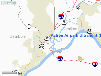
Action Airpark Ultralight |
|
|
Location
& QuickFacts
|
FAA
Information Effective: |
2007-12-20 |
|
Airport
Identifier: |
I38 |
|
Airport
Status: |
Operational |
|
Longitude/Latitude: |
084-49-43.0000W/39-07-57.0000N
-84.828611/39.132500 (Estimated) |
|
Elevation: |
465 ft / 141.73 m (Estimated) |
|
Land: |
18 acres |
|
From nearest
city: |
1 nautical miles NE of Hardenstown, IN |
|
Location: |
Dearborn County, IN |
|
Magnetic
Variation: |
03W (1990) |
Owner
& Manager
|
Ownership: |
Privately
owned |
|
Owner: |
Bill P. Fisher |
|
Address: |
119 Walnut St
Lawerenceburg, IN 47025 |
|
Phone
number: |
812-537-3389 |
|
Manager: |
Jim Robben
FOR ADDITIONAL INFO CONTACT MIKE WEHMNY 513-825-1234. |
|
Address: |
940 Hickory Rd
Lawerenceburg,
IN 47025 |
|
Phone
number: |
812-537-4088
AMGR 513-353-3874. |
Airport
Operations and Facilities
|
Airport
Use: |
Open
to public |
|
Wind indicator: |
Yes |
|
Segmented
Circle: |
Yes |
|
Control
Tower: |
No |
|
Landing
fee charge: |
Yes |
|
Sectional
chart: |
Cincinnati |
|
Region: |
AGL - Great Lakes |
|
Traffic
Pattern Alt: |
400 ft |
|
Boundary
ARTCC: |
ZID - Indianapolis |
|
Tie-in
FSS: |
HUF - Terre Haute |
|
FSS on
Airport: |
No |
|
FSS Toll
Free: |
1-800-WX-BRIEF |
|
NOTAMs
Facility: |
HUF (NOTAM-d service avaliable) |
Airport Communications
|
Runway Information
Runway 02/20
|
Dimension: |
1577 x 100 ft
/ 480.7 x 30.5 m |
|
Surface: |
TURF, Fair Condition |
|
|
Runway 02 |
Runway 20 |
|
Traffic
Pattern: |
Right |
Left |
|
Displaced
threshold: |
0.00 ft |
225.00 ft |
|
Obstruction: |
115 ft sign, 625.0 ft from runway, 100 ft right
of centerline, 5:1 slope to clear |
15 ft road, 0.0 ft from runway
APCH RATIO 15:1 AT DSPLCD THLD. |
|
Radio Navigation
Aids
|
ID |
Type |
Name |
Ch |
Freq |
Var |
Dist |
|
UR |
NDB |
Burln |
|
321.00 |
04W |
5.8 nm |
|
HAO |
NDB |
Hamilton |
|
260.00 |
04W |
18.7 nm |
|
ISZ |
NDB |
Cincinnati-blue Ash |
|
388.00 |
04W |
21.6 nm |
|
OXD |
NDB |
Oxford |
|
282.00 |
04W |
22.7 nm |
|
MDE |
NDB |
Madeira |
|
379.00 |
04W |
22.7 nm |
|
LUK |
NDB |
Cincinnati |
|
335.00 |
04W |
22.8 nm |
|
HLB |
NDB |
Batesville |
|
254.00 |
02W |
23.9 nm |
|
HKF |
NDB |
Hook Field |
|
239.00 |
04W |
28.3 nm |
|
PWF |
NDB |
Sportys |
|
245.00 |
04W |
28.8 nm |
|
OVO |
NDB |
North Vernon |
|
374.00 |
02W |
36.4 nm |
|
IMS |
NDB |
Madison |
|
404.00 |
03W |
37.0 nm |
|
HW |
NDB |
Cubla |
|
299.00 |
04W |
46.3 nm |
|
BA |
NDB |
Clifs |
|
410.00 |
03W |
47.5 nm |
|
FLM |
VOR/DME |
Falmouth |
117X |
117.00 |
04W |
37.8 nm |
|
CVG |
VORTAC |
Cincinnati |
120X |
117.30 |
04W |
9.1 nm |
|
RID |
VORTAC |
Richmond |
043X |
110.60 |
03W |
37.4 nm |
|
ABB |
VORTAC |
Nabb |
071X |
112.40 |
01E |
50.0 nm |
|
LUK |
VOT |
Cincinnati Muni/lunken |
|
108.40 |
|
20.0 nm |
Remarks
- INTERSTATE
275 APRXLY 1000 FT FM THLD OF RY 02.
- 115
FT BILLBOARD 150 FT R OF RY 20 CNTRLN.
- ULTRLIGHT
OPNS IN ACCORDANCE WITH FAR PART 103; OBSTNS REMOVED/LOWERED TO PROVIDE
20:1 CLEARANCE; TRAFFIC PATTERNS PUBLISHED TO SEPARATE ULTRALIGHTS &
SEAPLANE ACFT.
Based Aircraft
|
Aircraft
based on field: |
1 |
|
Ultralights: |
1 |
Operational Statistics
Time
Period: 1996-08-19 - 1997-08-18
|
Aircraft
Operations: |
37/Month |
|
General Aviation
Local: |
97.0% |
|
Military: |
3.0% |
Action Airpark Ultralight
Address:
Dearborn County, IN
Tel:
812-537-3389
Images
and information placed above are from
http://www.airport-data.com/airport/I38/
We
thank them for the data!
| General
Info |
| Country |
United
States |
| State |
INDIANA
|
| FAA ID |
I38 |
| Latitude |
39-07-57.000N
|
| Longitude |
084-49-43.000W
|
| Elevation |
465 feet
|
| Near City |
HARDENSTOWN
|
We don't guarantee the information is fresh and accurate. The data may
be wrong or outdated.
For more up-to-date information please refer to other sources.
|
|


