 |
|
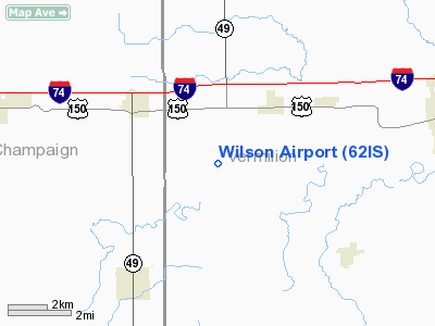
Location
& QuickFacts
|
FAA
Information Effective: |
2007-12-20 |
|
Airport
Identifier: |
62IS |
|
Airport
Status: |
Operational |
|
Longitude/Latitude: |
087-54-27.1130W/40-05-15.1260N
-87.907531/40.087535 (Estimated) |
|
Elevation: |
670 ft / 204.22 m (Estimated) |
|
Land: |
6 acres |
|
From nearest
city: |
2 nautical miles SW of Fithian, IL |
|
Location: |
Vermilion County, IL |
|
Magnetic
Variation: |
00W (1985) |
Owner
& Manager
|
Ownership: |
Privately
owned |
|
Owner: |
J Robert Wilson |
|
Address: |
1681 Lincoln Trail Road
Fithian,
IL 61844 |
|
Phone
number: |
217-548-2615 |
|
Address: |
|
Airport Operations
and Facilities
|
Airport
Use: |
Private |
|
Wind indicator: |
Yes |
|
Segmented
Circle: |
No |
|
Control
Tower: |
No |
|
Sectional
chart: |
Chicago |
|
Region: |
AGL - Great Lakes |
|
Boundary
ARTCC: |
ZAU - Chicago |
|
Tie-in
FSS: |
HUF - Terre Haute |
|
FSS Toll
Free: |
1-800-WX-BRIEF |
|
Runway Information
Runway N/S
|
Dimension: |
2640 x 100 ft
/ 804.7 x 30.5 m |
|
Surface: |
TURF, |
|
|
Runway N |
Runway S |
|
Traffic
Pattern: |
Left |
Left |
|
Radio Navigation
Aids
|
ID |
Type |
Name |
Ch |
Freq |
Var |
Dist |
|
HMJ |
NDB |
Homer |
|
281.00 |
01E |
4.2 nm |
|
PRG |
NDB |
Paris |
|
341.00 |
01E |
25.7 nm |
|
MT |
NDB |
Zebre |
|
347.00 |
00E |
40.7 nm |
|
CFJ |
NDB |
Crawfordsville |
|
388.00 |
02W |
46.1 nm |
|
CZB |
NDB |
Casey |
|
359.00 |
00E |
47.2 nm |
|
HU |
NDB |
Yinno |
|
245.00 |
02W |
48.2 nm |
|
RBS |
VOR/DME |
Roberts |
115X |
116.80 |
02E |
31.9 nm |
|
MTO |
VOR/DME |
Mattoon |
031X |
109.40 |
03E |
40.6 nm |
|
CMI |
VORTAC |
Champaign |
037X |
110.00 |
03E |
17.3 nm |
|
DNV |
VORTAC |
Danville |
047X |
111.00 |
02E |
20.3 nm |
|
TTH |
VORTAC |
Terre Haute |
100X |
115.30 |
02E |
47.1 nm |
|
BVT |
VORTAC |
Boiler |
098X |
115.10 |
01E |
47.6 nm |
|
DEC |
VORTAC |
Decatur |
119X |
117.20 |
03E |
48.5 nm |
Based Aircraft
|
Aircraft
based on field: |
2 |
|
Single Engine
Airplanes: |
1 |
|
Ultralights: |
1 |
Wilson Vermilion Airport
Address:
Vermilion County, IL
Tel:
217-548-2615
Images
and information placed above are from
http://www.airport-data.com/airport/62IS/
We
thank them for the data!
| General
Info |
| Country |
United
States |
| State |
ILLINOIS
|
| FAA ID |
62IS |
| Latitude |
40-05-15.126N
|
| Longitude |
087-54-27.113W
|
| Elevation |
670 feet
|
| Near City |
FITHIAN
|
We don't guarantee the information is fresh and accurate. The data may
be wrong or outdated.
For more up-to-date information please refer to other sources.
|
|


