|
|
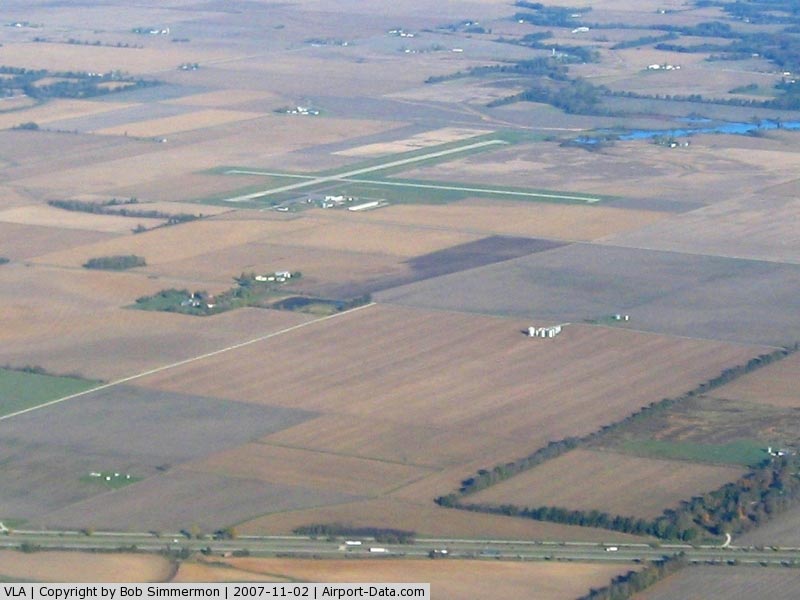
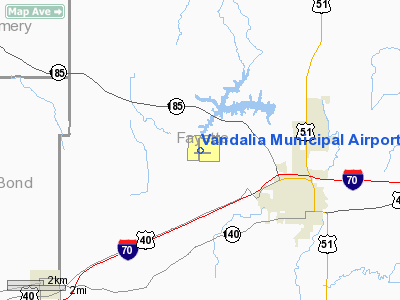
Vandalia Municipal Airport |
|
 |
(Click on the photo to enlarge) |
Location
& QuickFacts
|
FAA
Information Effective: |
2007-12-20 |
|
Airport
Identifier: |
VLA |
|
Airport
Status: |
Operational |
|
Longitude/Latitude: |
089-09-58.2810W/38-59-29.2770N
-89.166189/38.991466 (Estimated) |
|
Elevation: |
537 ft / 163.68 m (Surveyed) |
|
Land: |
246 acres |
|
From nearest
city: |
3 nautical miles NW of Vandalia, IL |
|
Location: |
Fayette County, IL |
|
Magnetic
Variation: |
01W (2005) |
Owner
& Manager
|
Ownership: |
Publicly
owned |
|
Owner: |
Vandalia Park District |
|
Address: |
900 North Locust
Vandalia, IL 62471 |
|
Phone
number: |
618-283-3176 |
|
Manager: |
Jason Mark |
|
Address: |
Vandalia Airport, Rt 3 Bx 602, 900 North
Locust
Vandalia, IL 62471 |
|
Phone
number: |
618-283-4973 |
Airport Operations
and Facilities
|
Airport
Use: |
Open
to public |
|
Wind indicator: |
Yes |
|
Segmented
Circle: |
Yes |
|
Control
Tower: |
No |
|
Lighting
Schedule: |
DUSK-DAWN
MIRL RY 18/36 PRESET ON LOW INTST; TO INCR INTST & ACTVT
MIRL RY 09/27, PAPI RY 18, AND REILS RY 18 & 27 - CTAF. |
|
Beacon
Color: |
Clear-Green (lighted land airport) |
|
Landing
fee charge: |
No |
|
Sectional
chart: |
St Louis |
|
Region: |
AGL - Great Lakes |
|
Boundary
ARTCC: |
ZKC - Kansas City |
|
Tie-in
FSS: |
STL - Saint Louis |
|
FSS on
Airport: |
No |
|
FSS Toll
Free: |
1-800-WX-BRIEF |
|
NOTAMs
Facility: |
STL (NOTAM-d service avaliable) |
|
Federal
Agreements: |
NGY |
Airport Communications
|
CTAF: |
122.800 |
|
Unicom: |
122.800
|
Airport
Services
|
Fuel
available: |
100LLA |
|
Bottled
Oxygen: |
NONE |
|
Bulk Oxygen: |
NONE |
|
Runway Information
Runway 09/27
|
Dimension: |
3001 x 75 ft
/ 914.7 x 22.9 m |
|
Surface: |
ASPH, Fair Condition |
|
Weight Limit: |
Single wheel: 19000 lbs. |
|
Edge Lights: |
Medium |
|
|
Runway 09 |
Runway 27 |
|
Longitude: |
089-10-12.5080W |
089-09-34.5010W |
|
Latitude: |
38-59-24.8250N |
38-59-24.9910N |
|
Elevation: |
532.00 ft |
537.00 ft |
|
Alignment: |
89 |
127 |
|
Traffic
Pattern: |
Left |
Left |
|
Markings: |
Basic, Fair Condition |
Basic, Fair Condition |
|
Runway End
Identifier: |
|
Yes |
|
Centerline
Lights: |
No |
No |
|
Touchdown
Lights: |
No |
No |
|
Obstruction: |
76 ft tree, 2805.0 ft from runway, 43 ft right
of centerline, 34:1 slope to clear |
64 ft tree, 2804.0 ft from runway, 198 ft left
of centerline, 40:1 slope to clear |
|
Runway 18/36
|
Dimension: |
3752 x 100 ft
/ 1143.6 x 30.5 m |
|
Surface: |
ASPH, Good Condition |
|
Surface Treatment: |
Porous Friction Course |
|
Weight Limit: |
Single wheel: 21000 lbs. |
|
Edge Lights: |
Medium |
|
|
Runway 18 |
Runway 36 |
|
Longitude: |
089-10-02.2350W |
089-10-01.9690W |
|
Latitude: |
38-59-51.3130N |
38-59-14.2310N |
|
Elevation: |
530.00 ft |
532.00 ft |
|
Alignment: |
127 |
127 |
|
Traffic
Pattern: |
Left |
Left |
|
Markings: |
Non-precision instrument, Good Condition |
Non-precision instrument, Good Condition |
|
Crossing
Height: |
20.00 ft |
0.00 ft |
|
VASI: |
4-light PAPI on left side |
|
|
Visual Glide
Angle: |
3.00° |
0.00° |
|
Runway End
Identifier: |
Yes |
No |
|
Centerline
Lights: |
No |
No |
|
Touchdown
Lights: |
No |
No |
|
Obstruction: |
18 ft road, 575.0 ft from runway, 284 ft left
of centerline, 20:1 slope to clear |
14 ft road, 522.0 ft from runway, 278 ft right
of centerline, 23:1 slope to clear
RWY 36 APCH SLOPE IS 23:1 TO RELOCATED THLD. |
|
Radio Navigation
Aids
|
ID |
Type |
Name |
Ch |
Freq |
Var |
Dist |
|
SLO |
NDB |
Salem |
|
400.00 |
01W |
22.9 nm |
|
LTD |
NDB |
Litchfield |
|
371.00 |
01E |
26.0 nm |
|
SYZ |
NDB |
Shelbyville |
|
365.00 |
01E |
29.1 nm |
|
TAZ |
NDB |
Taylorville |
|
395.00 |
00E |
33.5 nm |
|
FOA |
NDB |
Elm River |
|
353.00 |
00E |
38.6 nm |
|
CVM |
NDB |
Civic Memorial |
|
263.00 |
02E |
42.0 nm |
|
BL |
NDB |
Belleville |
|
362.00 |
02E |
42.0 nm |
|
OLY |
NDB |
Olney |
|
272.00 |
00W |
49.3 nm |
|
SKE |
TACAN |
Scott |
059X |
|
02E |
41.8 nm |
|
VNN |
VOR/DME |
Mount Vernon |
085X |
113.80 |
02E |
41.4 nm |
|
VLA |
VORTAC |
Vandalia |
090X |
114.30 |
04E |
6.1 nm |
|
BIB |
VORTAC |
Bible Grove |
027X |
109.00 |
03E |
32.3 nm |
|
ENL |
VORTAC |
Centralia |
097X |
115.00 |
04E |
34.3 nm |
|
TOY |
VORTAC |
Troy |
107X |
116.00 |
04E |
38.3 nm |
|
DEC |
VORTAC |
Decatur |
119X |
117.20 |
03E |
47.1 nm |
Based Aircraft
|
Aircraft
based on field: |
9 |
|
Single Engine
Airplanes: |
9 |
Operational Statistics
Time
Period: 2004-01-02 - 2004-12-31
|
Aircraft
Operations: |
192/Week |
|
General Aviation
Local: |
79.9% |
|
General Aviation
Itinerant: |
20.1% |
Vandalia Municipal Airport
Address:
Fayette County, IL
Tel:
618-283-3176,
618-283-4973
Images
and information placed above are from
http://www.airport-data.com/airport/VLA/
We
thank them for the data!
| General
Info |
| Country |
United
States |
| State |
ILLINOIS
|
| FAA ID |
VLA |
| Latitude |
38-59-29.277N
|
| Longitude |
089-09-58.281W
|
| Elevation |
537 feet
|
| Near City |
VANDALIA
|
We don't guarantee the information is fresh and accurate. The data may
be wrong or outdated.
For more up-to-date information please refer to other sources.
|
|