 |
|
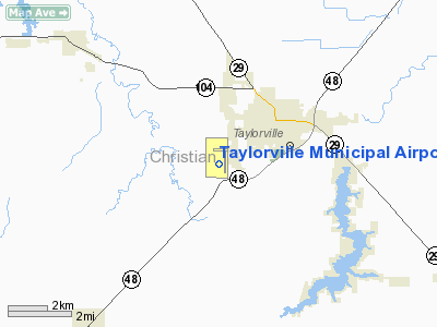
Taylorville Municipal Airport |
|
|
Location
& QuickFacts
|
FAA
Information Effective: |
2007-12-20 |
|
Airport
Identifier: |
TAZ |
|
Airport
Status: |
Operational |
|
Longitude/Latitude: |
089-19-50.4080W/39-31-57.2560N
-89.330669/39.532571 (Estimated) |
|
Elevation: |
622 ft / 189.59 m (Surveyed) |
|
Land: |
101 acres |
|
From nearest
city: |
2 nautical miles SW of Taylorville, IL |
|
Location: |
Christian County, IL |
|
Magnetic
Variation: |
00E (1995) |
Owner
& Manager
|
Ownership: |
Publicly
owned |
|
Owner: |
City Of Taylorville |
|
Address: |
City Hall-115 N. Main
Taylorville, IL 62568 |
|
Phone
number: |
217-824-2101 |
|
Manager: |
Bill Newberry |
|
Address: |
1501 S. Spresser
Taylorville, IL 62568 |
|
Phone
number: |
217-824-9313 |
Airport
Operations and Facilities
|
Airport
Use: |
Open
to public |
|
Wind indicator: |
Yes |
|
Segmented
Circle: |
Yes |
|
Control
Tower: |
No |
|
Lighting
Schedule: |
DUSK-DAWN
MIRL RY 18/36 PRE-SET ON LOW INTST. TO ACTVT RY 18/36 PSIL
& RY 18 REIL & HIGHER INTST FOR MIRL USE CTAF.
ALSO RY
9R/27L MIRL, PVASI'S & REILS, ACTVT - CTAF. |
|
Beacon
Color: |
Clear-Green (lighted land airport) |
|
Landing
fee charge: |
No |
|
Sectional
chart: |
St Louis |
|
Region: |
AGL - Great Lakes |
|
Traffic
Pattern Alt: |
800 ft |
|
Boundary
ARTCC: |
ZKC - Kansas City |
|
Tie-in
FSS: |
STL - Saint Louis |
|
FSS on
Airport: |
No |
|
FSS Toll
Free: |
1-800-WX-BRIEF |
|
NOTAMs
Facility: |
TAZ (NOTAM-d service avaliable) |
|
Federal
Agreements: |
NGY |
Airport
Communications
|
CTAF: |
122.800 |
|
Unicom: |
122.800
|
Airport
Services
|
Fuel
available: |
100LLA |
|
Airframe
Repair: |
MAJOR |
|
Power
Plant Repair: |
MAJOR |
|
Runway Information
Runway 09L/27R
|
Dimension: |
1920 x 180 ft
/ 585.2 x 54.9 m |
|
Surface: |
TURF, Good Condition |
|
|
Runway 09L |
Runway 27R |
|
Longitude: |
089-19-55.3240W |
089-19-30.8230W |
|
Latitude: |
39-32-17.1700N |
39-32-17.1690N |
|
Alignment: |
90 |
127 |
|
Traffic
Pattern: |
Left |
Left |
|
Markings: |
None,
THRS MKD WITH WHITE ROCKS. RY
27 THLDS NOT MKD. |
None,
RWY 27 THRS MARKED WITH L-SHAPED WHITE ROCK. |
|
Displaced
threshold: |
0.00 ft |
300.00 ft |
|
Runway End
Identifier: |
No |
No |
|
Centerline
Lights: |
No |
No |
|
Touchdown
Lights: |
No |
No |
|
Obstruction: |
11 ft tree, 247.0 ft from runway, 98 ft left
of centerline, 22:1 slope to clear |
14 ft road, 22.0 ft from runway, 1:1 slope
to clear
APCH RATIO TO DSPLCD THLD 21:1 DUE TO 28 FT BLDG 592 FT 96
FT L OF CNTRLN. |
|
Runway 09R/27L
|
Dimension: |
3500 x 60 ft
/ 1066.8 x 18.3 m |
|
Surface: |
ASPH, |
|
Edge Lights: |
Medium |
|
|
Runway 09R |
Runway 27L |
|
Longitude: |
089-20-30.1326W |
089-19-45.4483W |
|
Latitude: |
39-31-47.0620N |
39-31-47.4708N |
|
Elevation: |
616.00 ft |
616.00 ft |
|
Alignment: |
90 |
127 |
|
Traffic
Pattern: |
Left |
Left |
|
Markings: |
Basic, |
Basic, |
|
Crossing
Height: |
26.00 ft |
26.00 ft |
|
VASI: |
pulsating/steady burning on left side |
pulsating/steady burning on left side |
|
Visual Glide
Angle: |
3.00° |
3.00° |
|
Runway End
Identifier: |
Yes |
Yes |
|
Obstruction: |
27 ft trees, 750.0 ft from runway, 20:1 slope
to clear |
62 ft tree, 1470.0 ft from runway, 214 ft left
of centerline, 20:1 slope to clear |
|
Runway 18/36
|
Dimension: |
4001 x 75 ft
/ 1219.5 x 22.9 m |
|
Surface: |
ASPH, Fair Condition |
|
Surface Treatment: |
Porous Friction Course |
|
Edge Lights: |
Medium |
|
|
Runway 18 |
Runway 36 |
|
Longitude: |
089-19-39.0180W |
089-19-38.4120W |
|
Latitude: |
39-32-16.2150N |
39-31-36.6760N |
|
Elevation: |
615.00 ft |
620.00 ft |
|
Alignment: |
127 |
127 |
|
Traffic
Pattern: |
Left |
Left |
|
Markings: |
Non-precision instrument, Fair Condition
RY 18/36 MSRKINGS FADED. |
Non-precision instrument, Fair Condition |
|
Crossing
Height: |
39.00 ft |
34.00 ft |
|
VASI: |
pulsating/steady burning on left side
18/36 PSIL OPERATE ONLY WHEN RY LIGHTS ARE ACTIVATED BY CTAF. |
pulsating/steady burning on left side |
|
Visual Glide
Angle: |
3.00° |
3.00° |
|
Runway End
Identifier: |
Yes |
|
|
Obstruction: |
54 ft tree, 1490.0 ft from runway, 267 ft left
of centerline, 23:1 slope to clear |
57 ft tree, 1417.0 ft from runway, 89 ft left
of centerline, 21:1 slope to clear |
|
Radio Navigation
Aids
|
ID |
Type |
Name |
Ch |
Freq |
Var |
Dist |
|
TAZ |
NDB |
Taylorville |
|
395.00 |
00E |
0.4 nm |
|
SYZ |
NDB |
Shelbyville |
|
365.00 |
01E |
23.8 nm |
|
SP |
NDB |
Huskk |
|
382.00 |
01W |
24.6 nm |
|
LQ |
NDB |
Licol |
|
375.00 |
01W |
26.1 nm |
|
LTD |
NDB |
Litchfield |
|
371.00 |
01E |
27.3 nm |
|
AAA |
NDB |
Abraham |
|
329.00 |
00E |
37.7 nm |
|
IJX |
VOR/DME |
Jacksonville |
023X |
108.60 |
02E |
44.5 nm |
|
MTO |
VOR/DME |
Mattoon |
031X |
109.40 |
03E |
48.6 nm |
|
SPI |
VORTAC |
Spinner |
74X |
112.70 |
01W |
24.5 nm |
|
DEC |
VORTAC |
Decatur |
119X |
117.20 |
03E |
25.2 nm |
|
CAP |
VORTAC |
Capital |
074X |
112.70 |
04E |
25.6 nm |
|
VLA |
VORTAC |
Vandalia |
090X |
114.30 |
04E |
27.5 nm |
Remarks
- PLASI
LEFT SIDE OF RY 18 750' FM APPROACH END & PLASI LEFT SIDE OF RY
36 650'FM APPROACH END
- 172
FT HIGH WATER TWR LOCATED 3007' FR END OF RY 27L AND 488' LEFT OF RY
CENTERLINE. LIGHTED
WITH RED OBST LIGHTS.
Based Aircraft
|
Aircraft
based on field: |
24 |
|
Single Engine
Airplanes: |
22 |
|
Multi Engine Airplanes: |
1 |
|
Ultralights: |
1 |
Operational Statistics
Time
Period: 2005-09-01 - 2006-08-31
|
Aircraft
Operations: |
270/Week |
|
Air Taxi: |
1.4% |
|
General Aviation
Local: |
64.3% |
|
General Aviation
Itinerant: |
34.3% |
Taylorville Municipal Airport
Address:
Christian County, IL
Tel:
217-824-2101,
217-824-9313
Images
and information placed above are from
http://www.airport-data.com/airport/TAZ/
We
thank them for the data!
| General
Info |
| Country |
United
States |
| State |
ILLINOIS
|
| FAA ID |
TAZ |
| Latitude |
39-32-03.069N
|
| Longitude |
089-19-40.124W
|
| Elevation |
622 feet
|
| Near City |
TAYLORVILLE
|
We don't guarantee the information is fresh and accurate. The data may
be wrong or outdated.
For more up-to-date information please refer to other sources.
|
|


