 |
|
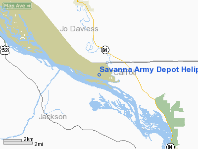
Savanna Army Depot Helipad Heliport |
|
|
Location
& QuickFacts
|
FAA
Information Effective: |
2007-12-20 |
|
Airport
Identifier: |
0LL9 |
|
Airport
Status: |
Operational |
|
Longitude/Latitude: |
090-15-20.4650W/42-11-00.0680N
-90.255685/42.183352 (Estimated) |
|
Elevation: |
650 ft / 198.12 m (Estimated) |
|
Land: |
0 acres |
|
From nearest
city: |
8 nautical miles NW of Savanna, IL |
|
Location: |
Carroll County, IL |
|
Magnetic
Variation: |
01E (1985) |
Owner
& Manager
|
Ownership: |
Army
owned |
|
Owner: |
Us Army Atca-aso |
|
Address: |
Cameron Station
Alexandria, VA 22314 |
|
Manager: |
Ltc Bogenrife |
|
Address: |
Savanna Army Depot
Savanna, IL 61074 |
|
Phone
number: |
815-273-8700 |
Airport
Operations and Facilities
|
Airport
Use: |
Private |
|
Wind indicator: |
Yes |
|
Segmented
Circle: |
No |
|
Control
Tower: |
No |
|
Lighting
Schedule: |
PHONE REQ
<
EXT 815-273-2211 REQUEST...CALL ON OPER LGTS> |
|
Landing
fee charge: |
No |
|
Sectional
chart: |
Chicago |
|
Region: |
AGL - Great Lakes |
|
Boundary
ARTCC: |
ZAU - Chicago |
|
Tie-in
FSS: |
IKK - Kankakee |
|
FSS
on Airport: |
No |
|
FSS
Toll Free: |
1-800-WX-BRIEF |
Airport
Services
|
Airframe
Repair: |
NONE |
|
Power
Plant Repair: |
NONE |
|
Runway Information
Helipad H1
|
Dimension: |
100 x 100 ft
/ 30.5 x 30.5 m |
|
Surface: |
CONC, |
|
Edge Lights: |
Low |
|
|
Runway H1 |
Runway |
|
Traffic
Pattern: |
Left |
Left |
|
Radio Navigation
Aids
|
ID |
Type |
Name |
Ch |
Freq |
Var |
Dist |
|
CWI |
NDB |
Clinton |
|
377.00 |
01E |
21.6 nm |
|
OQW |
NDB |
Maquoketa |
|
386.00 |
02E |
23.0 nm |
|
FEP |
NDB |
Freeport |
|
335.00 |
00E |
30.0 nm |
|
PVB |
NDB |
Platteville |
|
203.00 |
01E |
31.4 nm |
|
BOZ |
NDB |
Whiteside |
|
254.00 |
01E |
35.3 nm |
|
MXO |
NDB |
Monticello |
|
397.00 |
01E |
39.3 nm |
|
MRJ |
NDB |
Mineral Point |
|
365.00 |
00W |
42.4 nm |
|
PLL |
VOR/DME |
Polo |
049X |
111.20 |
03E |
35.2 nm |
|
RFD |
VOR/DME |
Rockford |
045X |
110.80 |
01E |
47.1 nm |
|
DBQ |
VORTAC |
Dubuque |
105X |
115.80 |
04E |
24.0 nm |
|
CVA |
VORTAC |
Davenport |
085X |
113.80 |
04E |
30.3 nm |
|
DVN |
VOT |
Davenport Municipal |
|
111.80 |
|
37.4 nm |
Remarks
- PPR
AUTOVON 585-8700.
- NO
SERVICES. APPROACH AND DEPART NORTH AND SOUTH.
- 160'
WATER TWR 4000' NORTHWEST.
- AVOID
RESTRICTED AREA R-3302, AND FLIGHT OVER BUILDINGS.
Savanna Army Depot Helipad Heliport
Address:
Carroll County, IL
Tel:
815-273-8700
Images
and information placed above are from
http://www.airport-data.com/airport/0LL9/
We
thank them for the data!
| General
Info |
| Country |
United
States |
| State |
ILLINOIS
|
| FAA ID |
0LL9 |
| Latitude |
42-11-00.068N
|
| Longitude |
090-15-20.465W
|
| Elevation |
650 feet
|
| Near City |
SAVANNA
|
We don't guarantee the information is fresh and accurate. The data may
be wrong or outdated.
For more up-to-date information please refer to other sources.
|
|


