 |
|
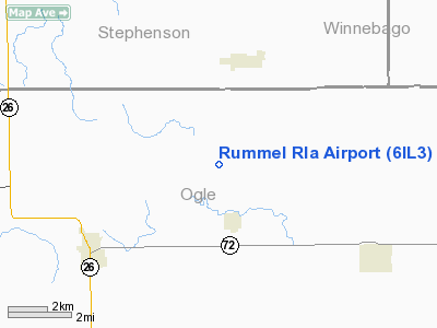
Location
& QuickFacts
|
FAA
Information Effective: |
2007-12-20 |
|
Airport
Identifier: |
6IL3 |
|
Airport
Status: |
Operational |
|
Longitude/Latitude: |
089-30-00.4040W/42-10-00.0890N
-89.500112/42.166691 (Estimated) |
|
Elevation: |
850 ft / 259.08 m (Estimated) |
|
Land: |
0 acres |
|
From nearest
city: |
3 nautical miles SW of German Valley, IL |
|
Location: |
Ogle County, IL |
|
Magnetic
Variation: |
00E (1985) |
Owner
& Manager
|
Ownership: |
Privately
owned |
|
Owner: |
John C. Rummel |
|
Address: |
German Valley, IL 61039 |
|
Phone
number: |
815-938-2373 |
|
Address: |
|
Airport
Operations and Facilities
|
Airport Use: |
Private |
|
Wind
indicator: |
No |
|
Segmented
Circle: |
No |
|
Control
Tower: |
No |
|
Landing
fee charge: |
No |
|
Sectional
chart: |
Chicago |
|
Region: |
AGL - Great Lakes |
|
Boundary
ARTCC: |
ZAU - Chicago |
|
Tie-in
FSS: |
IKK - Kankakee |
|
FSS
on Airport: |
No |
|
FSS
Toll Free: |
1-800-WX-BRIEF |
Airport
Services
|
Airframe
Repair: |
NONE |
|
Power
Plant Repair: |
NONE |
|
Runway Information
Runway 09/27
|
Dimension: |
1500 x 70 ft
/ 457.2 x 21.3 m |
|
Surface: |
TURF, |
|
|
Runway 09 |
Runway 27 |
|
Traffic
Pattern: |
Right |
Right |
|
Runway 13/31
|
Dimension: |
1200 x 70 ft
/ 365.8 x 21.3 m |
|
Surface: |
TURF, |
|
|
Runway 13 |
Runway 31 |
|
Traffic
Pattern: |
Right |
Right |
|
Radio Navigation
Aids
|
ID |
Type |
Name |
Ch |
Freq |
Var |
Dist |
|
FEP |
NDB |
Freeport |
|
335.00 |
00E |
6.1 nm |
|
BOZ |
NDB |
Whiteside |
|
254.00 |
01E |
30.2 nm |
|
JVL |
NDB |
Janesville |
|
375.00 |
03E |
33.8 nm |
|
DKB |
NDB |
Dekalb |
|
209.00 |
02W |
38.0 nm |
|
CWI |
NDB |
Clinton |
|
377.00 |
01E |
42.2 nm |
|
PLL |
VOR/DME |
Polo |
049X |
111.20 |
03E |
12.1 nm |
|
RFD |
VOR/DME |
Rockford |
045X |
110.80 |
01E |
13.9 nm |
|
JVL |
VOR/DME |
Janesville |
090X |
114.30 |
03E |
29.3 nm |
Remarks
Rummel Rla Airport
Address:
Ogle County, IL
Tel:
815-938-2373
Images
and information placed above are from
http://www.airport-data.com/airport/6IL3/
We
thank them for the data!
| General
Info |
| Country |
United
States |
| State |
ILLINOIS
|
| FAA ID |
6IL3 |
| Latitude |
42-10-00.089N
|
| Longitude |
089-30-00.404W
|
| Elevation |
850 feet
|
| Near City |
GERMAN
VALLEY |
We don't guarantee the information is fresh and accurate. The data may
be wrong or outdated.
For more up-to-date information please refer to other sources.
|
|


