 |
|
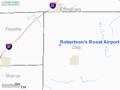
Robertson's Roost Airport |
Location
& QuickFacts
|
FAA
Information Effective: |
2007-12-20 |
|
Airport
Identifier: |
8IL6 |
|
Airport
Status: |
Operational |
|
Longitude/Latitude: |
088-39-31.0000W/38-51-34.0000N
-88.658611/38.859444 (Estimated) |
|
Elevation: |
542 ft / 165.20 m (Estimated) |
|
Land: |
0 acres |
|
From nearest
city: |
4 nautical miles S of Edgewood, IL |
|
Location: |
Clay County, IL |
|
Magnetic
Variation: |
01W (2000) |
Owner
& Manager
|
Ownership: |
Privately
owned |
|
Owner: |
James E. Robertson |
|
Address: |
26230 W Arpt Rd
Minooka,
IL 60047 |
|
Phone
number: |
815-467-6924 |
|
Manager: |
James E. Robertson |
|
Address: |
26230 W Arpt Rd
Minooka,
IL 60447 |
|
Phone
number: |
815-467-6924 |
Airport Operations
and Facilities
|
Airport
Use: |
Private |
|
Segmented
Circle: |
No |
|
Control
Tower: |
No |
|
Sectional
chart: |
St Louis |
|
Region: |
AGL - Great Lakes |
|
Boundary
ARTCC: |
ZKC - Kansas City |
|
Tie-in
FSS: |
COU - Columbia |
|
FSS Toll
Free: |
1-800-WX-BRIEF |
|
Runway Information
Runway 18/36
|
Dimension: |
2080 x 90 ft
/ 634.0 x 27.4 m |
|
Surface: |
TURF, |
|
|
Runway 18 |
Runway 36 |
|
Traffic
Pattern: |
Left |
Left |
|
Obstruction: |
28 ft pline, 590.0 ft from runway |
|
|
Radio Navigation
Aids
|
ID |
Type |
Name |
Ch |
Freq |
Var |
Dist |
|
FOA |
NDB |
Elm River |
|
353.00 |
00E |
15.0 nm |
|
SLO |
NDB |
Salem |
|
400.00 |
01W |
19.4 nm |
|
OLY |
NDB |
Olney |
|
272.00 |
00W |
24.3 nm |
|
FWC |
NDB |
Wayne County |
|
257.00 |
01E |
31.1 nm |
|
SYZ |
NDB |
Shelbyville |
|
365.00 |
01E |
34.0 nm |
|
CZB |
NDB |
Casey |
|
359.00 |
00E |
40.7 nm |
|
MT |
NDB |
Zebre |
|
347.00 |
00E |
41.7 nm |
|
AJG |
NDB |
Mount Carmel |
|
524.00 |
02W |
46.2 nm |
|
PLX |
NDB |
Palestine |
|
391.00 |
00W |
48.5 nm |
|
VNN |
VOR/DME |
Mount Vernon |
085X |
113.80 |
02E |
30.7 nm |
|
SAM |
VOR/DME |
Samsville |
113X |
116.60 |
03E |
35.1 nm |
|
MTO |
VOR/DME |
Mattoon |
031X |
109.40 |
03E |
41.0 nm |
|
RSV |
VOR/DME |
Robinson |
021X |
108.40 |
02E |
48.2 nm |
|
LWV |
VOR/DME |
Lawrenceville |
025X |
108.80 |
01W |
49.7 nm |
|
BIB |
VORTAC |
Bible Grove |
027X |
109.00 |
03E |
9.0 nm |
|
VLA |
VORTAC |
Vandalia |
090X |
114.30 |
04E |
27.4 nm |
|
ENL |
VORTAC |
Centralia |
097X |
115.00 |
04E |
35.3 nm |
Remarks
- TRMSN
LINE HAS OBSTN LGTS & DAY MKRS.
- BE
ALERT: ALL TWYS UNDER CONSTRUCTION.
- PPR
FOR TSNT ACFT CALL AMGR 708-532-1100.
Robertson's Roost Airport
Address:
Clay County, IL
Tel:
815-467-6924
Images
and information placed above are from
http://www.airport-data.com/airport/8IL6/
We
thank them for the data!
| General
Info |
| Country |
United
States |
| State |
ILLINOIS
|
| FAA ID |
8IL6 |
| Latitude |
38-51-34.000N
|
| Longitude |
088-39-31.000W
|
| Elevation |
542 feet
|
| Near City |
EDGEWOOD
|
We don't guarantee the information is fresh and accurate. The data may
be wrong or outdated.
For more up-to-date information please refer to other sources.
|
|


