 |
|
Palos Community Hospital Heliport |
|
|
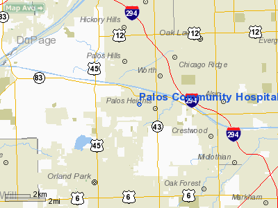
Location
& QuickFacts
|
FAA
Information Effective: |
2007-12-20 |
|
Airport
Identifier: |
20IL |
|
Airport
Status: |
Operational |
|
Longitude/Latitude: |
087-48-47.1910W/41-40-08.1170N
-87.813109/41.668921 (Estimated) |
|
Elevation: |
717 ft / 218.54 m (Surveyed)
ROOFTOP HELIPORT. |
|
Land: |
0 acres |
|
From nearest
city: |
0 nautical miles W of Palos Heights, IL |
|
Location: |
Cook County, IL |
|
Magnetic
Variation: |
01W (1985) |
Owner
& Manager
|
Ownership: |
Privately
owned |
|
Owner: |
Palos Community Hospital |
|
Address: |
12251 S. 80th Avenue
Palos Heights, IL 60463 |
|
Phone
number: |
708-923-4000 |
|
Manager: |
David Manchester |
|
Address: |
12251 S. 80th Avenue
Palos Heights, IL 60463 |
|
Phone
number: |
708-923-4000 |
Airport Operations
and Facilities
|
Airport
Use: |
Private
MEDICAL USE. |
|
Wind indicator: |
Yes |
|
Segmented
Circle: |
No |
|
Control
Tower: |
No |
|
Lighting
Schedule: |
24 HRS
FOR PERIMETER LGTS KEY 123.05 5 TIMES; 1 TIME FOR OFF. |
|
Beacon
Color: |
Clear-Green-Yellow (heliport) |
|
Sectional
chart: |
Chicago |
|
Region: |
AGL - Great Lakes |
|
Boundary
ARTCC: |
ZAU - Chicago |
|
Tie-in
FSS: |
IKK - Kankakee |
|
FSS Toll
Free: |
1-800-WX-BRIEF |
Airport
Communications
|
Runway Information
Helipad H1
|
Dimension: |
54 x 46 ft /
16.5 x 14.0 m |
|
Surface: |
CONC, |
|
|
Runway H1 |
Runway |
|
Traffic
Pattern: |
Left |
Left |
|
Radio Navigation
Aids
|
ID |
Type |
Name |
Ch |
Freq |
Var |
Dist |
|
HK |
NDB |
Ermin |
|
332.00 |
01W |
3.2 nm |
|
MX |
NDB |
Kedzi |
|
248.00 |
01W |
7.1 nm |
|
ME |
NDB |
Deana |
|
350.00 |
00E |
20.4 nm |
|
DKB |
NDB |
Dekalb |
|
209.00 |
02W |
43.1 nm |
|
VP |
NDB |
Sedly |
|
212.00 |
02W |
44.1 nm |
|
MGC |
NDB |
Michigan City |
|
203.00 |
01W |
44.8 nm |
|
IUL |
NDB |
La Porte |
|
356.00 |
03W |
47.9 nm |
|
ORD |
VOR/DME |
Chicago O'hare |
086X |
113.90 |
02E |
19.6 nm |
|
DPA |
VOR/DME |
Dupage |
021X |
108.40 |
02E |
27.5 nm |
|
OBK |
VOR/DME |
Northbrook |
077X |
113.00 |
02W |
33.8 nm |
|
IKK |
VOR/DME |
Kankakee |
053X |
111.60 |
00E |
35.8 nm |
|
CGT |
VORTAC |
Chicago Heights |
089X |
114.20 |
02E |
14.5 nm |
|
JOT |
VORTAC |
Joliet |
070X |
112.30 |
02E |
23.9 nm |
|
EON |
VORTAC |
Peotone |
079X |
113.20 |
02E |
24.0 nm |
|
MDW |
VOT |
Chicago Midway |
|
111.00 |
|
7.6 nm |
|
ORD |
VOT |
Chicago O'hare Intl |
|
112.00 |
|
19.3 nm |
Remarks
- PRVDD
APCH/DEP CONDUCTED 180 DEG AND 360 DEG; TAKE OFF/LDNG AREA MKD; MAINTAIN
WIND INDICATOR; TREE SOUTH OFHELIPAD BE REMOVED OR TOPPED TO PRVD 8:1
SLOPE.
Palos Community Hospital Heliport
Address:
Cook County, IL
Tel:
708-923-4000
Images
and information placed above are from
http://www.airport-data.com/airport/20IL/
We
thank them for the data!
| General
Info |
| Country |
United
States |
| State |
ILLINOIS
|
| FAA ID |
20IL |
| Latitude |
41-40-08.117N
|
| Longitude |
087-48-47.191W
|
| Elevation |
717 feet
|
| Near City |
PALOS
HEIGHTS |
We don't guarantee the information is fresh and accurate. The data may
be wrong or outdated.
For more up-to-date information please refer to other sources.
|
|


