|
|
|
 |
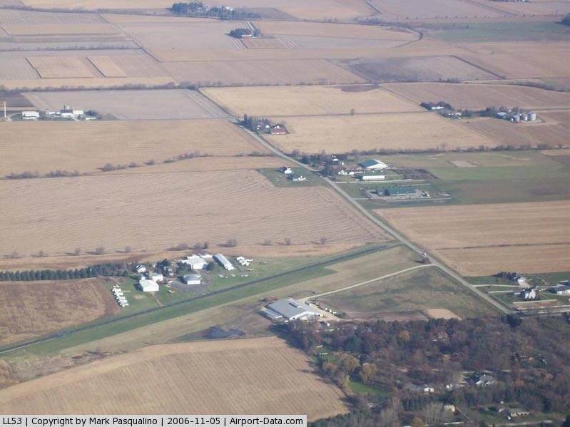
(Click on the photo to enlarge) |
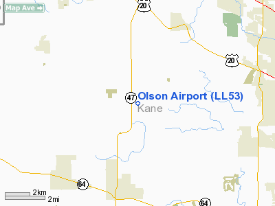
Location
& QuickFacts
|
FAA
Information Effective: |
2007-12-20 |
|
Airport
Identifier: |
LL53 |
|
Airport
Status: |
Operational |
|
Longitude/Latitude: |
088-27-27.2940W/42-00-32.0950N
-88.457582/42.008915 (Estimated) |
|
Elevation: |
955 ft / 291.08 m (Estimated) |
|
Land: |
0 acres |
|
From nearest
city: |
2 nautical miles SW of Plato Center, IL |
|
Location: |
Kane County, IL |
|
Magnetic
Variation: |
00W (1985) |
Owner
& Manager
|
Ownership: |
Privately
owned |
|
Owner: |
Paul C. Olson |
|
Address: |
2170 W Frost Rd
Schaumburg, IL 60195 |
|
Phone
number: |
312-358-4035 |
|
Manager: |
Paul Olson |
|
Address: |
|
|
Phone
number: |
708-464-5280 |
Airport Operations
and Facilities
|
Airport Use: |
Private |
|
Wind
indicator: |
Yes |
|
Segmented
Circle: |
No |
|
Control
Tower: |
No |
|
Landing
fee charge: |
No |
|
Sectional
chart: |
Chicago |
|
Region: |
AGL - Great Lakes |
|
Boundary
ARTCC: |
ZAU - Chicago |
|
Tie-in
FSS: |
IKK - Kankakee |
|
FSS on
Airport: |
No |
|
FSS Toll
Free: |
1-800-WX-BRIEF |
Airport Services
|
Fuel
available: |
100 |
|
Airframe
Repair: |
MINOR |
|
Power
Plant Repair: |
MINOR |
|
Runway Information
Runway NE/SW
|
Dimension: |
2400 x 100
ft / 731.5 x 30.5 m
28 FT WIDE ASPH STRIP ALONG NORTH SIDE OF CNTRLN. |
|
Surface: |
ASPH-TURF, |
|
|
Runway NE |
Runway SW |
|
Traffic
Pattern: |
Left |
Right |
|
Radio Navigation
Aids
|
ID |
Type |
Name |
Ch |
Freq |
Var |
Dist |
|
DKB |
NDB |
Dekalb |
|
209.00 |
02W |
12.0 nm |
|
ME |
NDB |
Deana |
|
350.00 |
00E |
19.4 nm |
|
HK |
NDB |
Ermin |
|
332.00 |
01W |
32.8 nm |
|
MX |
NDB |
Kedzi |
|
248.00 |
01W |
37.9 nm |
|
LVV |
NDB |
Lake Lawn |
|
404.00 |
00W |
41.9 nm |
|
OIX |
NDB |
Ottawa |
|
266.00 |
01E |
42.7 nm |
|
JVL |
NDB |
Janesville |
|
375.00 |
03E |
44.7 nm |
|
RA |
NDB |
Paser |
|
206.00 |
00E |
47.5 nm |
|
DPA |
VOR/DME |
Dupage |
021X |
108.40 |
02E |
8.6 nm |
|
ORD |
VOR/DME |
Chicago O'hare |
086X |
113.90 |
02E |
24.7 nm |
|
OBK |
VOR/DME |
Northbrook |
077X |
113.00 |
02W |
25.9 nm |
|
RFD |
VOR/DME |
Rockford |
045X |
110.80 |
01E |
35.5 nm |
|
BUU |
VOR/DME |
Burbun |
092X |
114.50 |
01W |
41.5 nm |
|
ENW |
VOR/DME |
Kenosha |
029X |
109.20 |
02W |
42.5 nm |
|
JVL |
VOR/DME |
Janesville |
090X |
114.30 |
03E |
43.8 nm |
|
PLL |
VOR/DME |
Polo |
049X |
111.20 |
03E |
47.7 nm |
|
JOT |
VORTAC |
Joliet |
070X |
112.30 |
02E |
28.5 nm |
|
CGT |
VORTAC |
Chicago Heights |
089X |
114.20 |
02E |
49.8 nm |
|
ORD |
VOT |
Chicago O'hare Intl |
|
112.00 |
|
24.6 nm |
|
MDW |
VOT |
Chicago Midway |
|
111.00 |
|
34.3 nm |
Remarks
- OBSTRUCTIONS
IN RY APCH SLOPE SFC REMOVED OR LOWERED, OR RY THLD DSPLCD AND MARKED
TO PROVIDE MINIMUM 20:1 APCH CLNC OVER OBSTRUCTIONS.
Based Aircraft
|
Aircraft
based on field: |
70 |
|
Single Engine
Airplanes: |
65 |
|
Multi Engine Airplanes: |
5 |
Olson Kane Airport
Address:
Kane County, IL
Tel:
312-358-4035,
708-464-5280
Images
and information placed above are from
http://www.airport-data.com/airport/LL53/
We
thank them for the data!
| General
Info |
| Country |
United
States |
| State |
ILLINOIS
|
| FAA ID |
LL53 |
| Latitude |
42-00-32.095N
|
| Longitude |
088-27-27.294W
|
| Elevation |
955 feet
|
| Near City |
PLATO
CENTER |
We don't guarantee the information is fresh and accurate. The data may
be wrong or outdated.
For more up-to-date information please refer to other sources.
|
|