 |
|
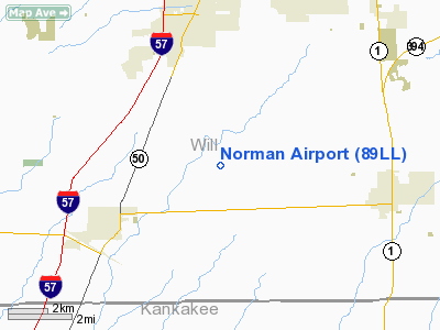
Location
& QuickFacts
|
FAA
Information Effective: |
2007-12-20 |
|
Airport
Identifier: |
89LL |
|
Airport
Status: |
Operational |
|
Longitude/Latitude: |
087-43-30.1530W/41-21-30.1210N
-87.725043/41.358367 (Estimated) |
|
Elevation: |
750 ft / 228.60 m (Estimated) |
|
Land: |
6 acres |
|
From nearest
city: |
3 nautical miles NE of Peotone, IL |
|
Location: |
Will County, IL |
|
Magnetic
Variation: |
01W (1985) |
Owner
& Manager
|
Ownership: |
Privately
owned |
|
Owner: |
Robert Norman |
|
Address: |
29342 S. Will Center Rd
Peotone, IL 60468 |
|
Phone
number: |
708-258-3533 |
|
Manager: |
William Hunt |
|
Address: |
29262 S. Will Center Rd
Peotone, IL 60468 |
|
Phone
number: |
708-258-0055 |
Airport Operations
and Facilities
|
Airport Use: |
Private |
|
Wind
indicator: |
Yes |
|
Segmented
Circle: |
No |
|
Control
Tower: |
No |
|
Landing
fee charge: |
No |
|
Sectional
chart: |
Chicago |
|
Region: |
AGL - Great Lakes |
|
Boundary
ARTCC: |
ZAU - Chicago |
|
Tie-in
FSS: |
IKK - Kankakee |
|
FSS on
Airport: |
No |
|
FSS Toll
Free: |
1-800-WX-BRIEF |
Airport
Communications
|
Runway Information
Runway 09/27
|
Dimension: |
2500 x 100 ft
/ 762.0 x 30.5 m |
|
Surface: |
TURF, |
|
|
Runway 09 |
Runway 27 |
|
Traffic
Pattern: |
Left |
Left |
|
Obstruction: |
|
30 ft pline, 450.0 ft from runway |
|
Radio Navigation
Aids
|
ID |
Type |
Name |
Ch |
Freq |
Var |
Dist |
|
HK |
NDB |
Ermin |
|
332.00 |
01W |
22.2 nm |
|
MX |
NDB |
Kedzi |
|
248.00 |
01W |
23.1 nm |
|
RZL |
NDB |
Rensselaer |
|
362.00 |
02W |
34.8 nm |
|
VP |
NDB |
Sedly |
|
212.00 |
02W |
38.6 nm |
|
ME |
NDB |
Deana |
|
350.00 |
00E |
39.1 nm |
|
IUL |
NDB |
La Porte |
|
356.00 |
03W |
43.8 nm |
|
MGC |
NDB |
Michigan City |
|
203.00 |
01W |
45.9 nm |
|
IKK |
VOR/DME |
Kankakee |
053X |
111.60 |
00E |
18.0 nm |
|
ORD |
VOR/DME |
Chicago O'hare |
086X |
113.90 |
02E |
38.7 nm |
|
DPA |
VOR/DME |
Dupage |
021X |
108.40 |
02E |
42.6 nm |
|
OXI |
VOR/DME |
Knox |
103X |
115.60 |
00E |
48.6 nm |
|
EON |
VORTAC |
Peotone |
079X |
113.20 |
02E |
6.1 nm |
|
CGT |
VORTAC |
Chicago Heights |
089X |
114.20 |
02E |
11.4 nm |
|
JOT |
VORTAC |
Joliet |
070X |
112.30 |
02E |
29.0 nm |
|
MDW |
VOT |
Chicago Midway |
|
111.00 |
|
25.7 nm |
|
ORD |
VOT |
Chicago O'hare Intl |
|
112.00 |
|
38.4 nm |
Remarks
- E111:DUE
TO THE ARPT TRAFFIC PATTERN AIRSPACE AREA WOULD BE INCOMPATIBLE WITH
THE SAME AREA ASSOCIATED WITH RWYS 09/27 & 05/23 AT SANGER ARPT.
Based Aircraft
|
Aircraft
based on field: |
1 |
|
Single Engine
Airplanes: |
1 |
Norman Airport
Address:
Will County, IL
Tel:
708-258-3533,
708-258-0055
Images
and information placed above are from
http://www.airport-data.com/airport/89LL/
We
thank them for the data!
| General
Info |
| Country |
United
States |
| State |
ILLINOIS
|
| FAA ID |
89LL |
| Latitude |
41-21-30.121N
|
| Longitude |
087-43-30.153W
|
| Elevation |
750 feet
|
| Near City |
PEOTONE
|
We don't guarantee the information is fresh and accurate. The data may
be wrong or outdated.
For more up-to-date information please refer to other sources.
|
|


