 |
|
|
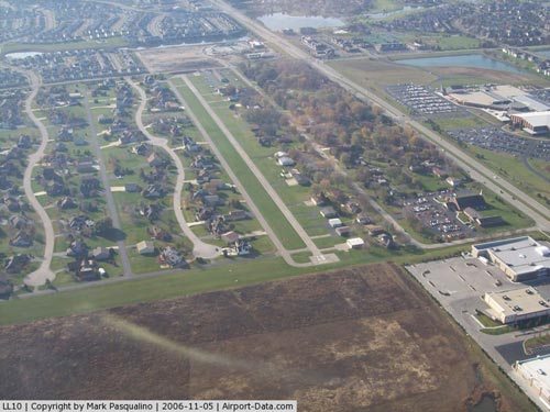 |
(Click on the photo to enlarge) |
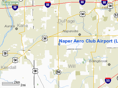
Location
& QuickFacts
|
FAA
Information Effective: |
2007-12-20 |
|
Airport
Identifier: |
LL10 |
|
Airport
Status: |
Operational |
|
Longitude/Latitude: |
088-12-12.2420W/41-44-05.1060N
-88.203401/41.734752 (Estimated) |
|
Elevation: |
708 ft / 215.80 m (Estimated) |
|
Land: |
21 acres |
|
From nearest
city: |
3 nautical miles SW of Naperville, IL |
|
Location: |
Du Page County, IL |
|
Magnetic
Variation: |
01W (1995) |
Owner
& Manager
|
Ownership: |
Privately
owned |
|
Owner: |
Naper Aero Club Inc |
|
Address: |
9 S 357 Aero Dr
Naperville, IL 60564 |
|
Phone
number: |
630-416-4327 |
|
Manager: |
Mark Clements |
|
Address: |
855 Plainfield-naperville Rd
Naperville,
IL 60540 |
Airport
Operations and Facilities
|
Airport
Use: |
Private |
|
Wind indicator: |
Yes |
|
Segmented
Circle: |
No |
|
Control
Tower: |
No |
|
Lighting
Schedule: |
RDO-CTL
LIRL RY 18/36 PRESET ON LOW INTST; TO INCR INTST ACTVT -
122.9. |
|
Landing
fee charge: |
No |
|
Sectional
chart: |
Chicago |
|
Region: |
AGL - Great Lakes |
|
Boundary
ARTCC: |
ZAU - Chicago |
|
Tie-in
FSS: |
IKK - Kankakee |
|
FSS on
Airport: |
No |
|
FSS Toll
Free: |
1-800-WX-BRIEF |
Airport Services
|
Fuel
available: |
100
80 |
|
Airframe
Repair: |
NONE |
|
Power
Plant Repair: |
NONE |
|
Runway Information
Runway 09/27
|
Dimension: |
1750 x 70 ft
/ 533.4 x 21.3 m |
|
Surface: |
TURF,
SLIPPERY WHEN WET. |
|
|
Runway 09 |
Runway 27 |
|
Traffic
Pattern: |
Left |
Left |
|
Displaced
threshold: |
150.00 ft |
0.00 ft |
|
Obstruction: |
28 ft house, 270.0 ft from runway, 1:1 slope
to clear |
|
|
Runway 18/36
|
Dimension: |
2575 x 30 ft
/ 784.9 x 9.1 m |
|
Surface: |
ASPH,
SLIPPERY WHEN WET. |
|
Edge Lights: |
Low |
|
|
Runway 18 |
Runway 36 |
|
Longitude: |
088-12-11.0400W |
088-12-12.2500W |
|
Latitude: |
41-44-18.8200N |
41-43-53.4000N |
|
Elevation: |
702.00 ft |
706.00 ft |
|
Traffic
Pattern: |
Left |
Left |
|
Displaced
threshold: |
0.00 ft |
260.00 ft |
|
Obstruction: |
|
15 ft road, 50.0 ft from runway |
|
Radio Navigation
Aids
|
ID |
Type |
Name |
Ch |
Freq |
Var |
Dist |
|
ME |
NDB |
Deana |
|
350.00 |
00E |
16.1 nm |
|
HK |
NDB |
Ermin |
|
332.00 |
01W |
16.5 nm |
|
MX |
NDB |
Kedzi |
|
248.00 |
01W |
23.0 nm |
|
DKB |
NDB |
Dekalb |
|
209.00 |
02W |
25.6 nm |
|
OIX |
NDB |
Ottawa |
|
266.00 |
01E |
36.8 nm |
|
VYS |
NDB |
Valley |
|
230.00 |
00W |
48.2 nm |
|
DPA |
VOR/DME |
Dupage |
021X |
108.40 |
02E |
11.4 nm |
|
ORD |
VOR/DME |
Chicago O'hare |
086X |
113.90 |
02E |
20.2 nm |
|
OBK |
VOR/DME |
Northbrook |
077X |
113.00 |
02W |
31.3 nm |
|
IKK |
VOR/DME |
Kankakee |
053X |
111.60 |
00E |
42.8 nm |
|
JOT |
VORTAC |
Joliet |
070X |
112.30 |
02E |
12.4 nm |
|
CGT |
VORTAC |
Chicago Heights |
089X |
114.20 |
02E |
31.4 nm |
|
EON |
VORTAC |
Peotone |
079X |
113.20 |
02E |
33.6 nm |
|
ORD |
VOT |
Chicago O'hare Intl |
|
112.00 |
|
19.9 nm |
|
MDW |
VOT |
Chicago Midway |
|
111.00 |
|
20.5 nm |
Remarks
- RWY
36 ACFT PARKED ON PRIM SFC.
- RY
18 HAS 2330 FT AVBL FOR USE DURING TKOF.
- PROVIDED
RWY 18/36 PARALLEL TWY IS RLCTD TO THE E TO PROVIDE 150' SEPARATION
BTN RWY 18/36 AND TWY CNTRLNS;NO ACFT PARKED WITHIN RWY PRIMARY SFCS
Based Aircraft
|
Aircraft
based on field: |
110 |
|
Single Engine
Airplanes: |
106 |
|
Multi Engine Airplanes: |
3 |
|
Helicopters: |
1 |
Naper Aero Club Airport
Address:
Du Page County, IL
Tel:
630-416-4327
Images
and information placed above are from
http://www.airport-data.com/airport/LL10/
We
thank them for the data!
| General
Info |
| Country |
United
States |
| State |
ILLINOIS
|
| FAA ID |
LL10 |
| Latitude |
41-44-05.106N
|
| Longitude |
088-12-12.242W
|
| Elevation |
708 feet
|
| Near City |
NAPERVILLE
|
We don't guarantee the information is fresh and accurate. The data may
be wrong or outdated.
For more up-to-date information please refer to other sources.
|
|


