 |
|
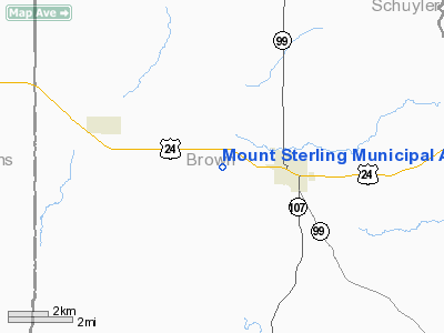
Mount Sterling Municipal Airport |
|
|
Location
& QuickFacts
|
FAA
Information Effective: |
2007-12-20 |
|
Airport
Identifier: |
I63 |
|
Airport
Status: |
Operational |
|
Longitude/Latitude: |
090-48-15.0000W/39-59-15.0000N
-90.804167/39.987500 (Estimated) |
|
Elevation: |
732 ft / 223.11 m (Surveyed) |
|
Land: |
200 acres |
|
From nearest
city: |
2 nautical miles W of Mount Sterling, IL |
|
Location: |
Brown County, IL |
|
Magnetic
Variation: |
01E (1995) |
Owner
& Manager
|
Ownership: |
Publicly
owned |
|
Owner: |
City Of Mount Sterling |
|
Address: |
145 W. Main
Mount Sterling, IL 62353 |
|
Phone
number: |
217-773-2513 |
|
Manager: |
Billie Burge |
|
Address: |
145 W. Main
Mount Sterling, IL 62353 |
|
Phone
number: |
217-773-2513 |
Airport Operations
and Facilities
|
Airport
Use: |
Open
to public |
|
Wind indicator: |
Yes |
|
Segmented
Circle: |
No |
|
Control
Tower: |
No |
|
Lighting
Schedule: |
DUSK-DAWN
ACTVT MIRL RY 18/36 - CTAF. |
|
Beacon
Color: |
Clear-Green (lighted land airport) |
|
Sectional
chart: |
St Louis |
|
Region: |
AGL - Great Lakes |
|
Boundary
ARTCC: |
ZKC - Kansas City |
|
Tie-in
FSS: |
STL - Saint Louis |
|
FSS Toll
Free: |
1-800-WX-BRIEF |
|
NOTAMs
Facility: |
STL (NOTAM-d service avaliable) |
|
Federal
Agreements: |
N |
Airport Communications
|
CTAF: |
122.800 |
|
Unicom: |
122.800
|
Airport
Services
|
Fuel
available: |
100LLA
FUEL NOW AVBL TO PUBLIC - SELF SERVICE. |
|
Runway Information
Runway 18/36
|
Dimension: |
5905 x 75 ft
/ 1799.8 x 22.9 m |
|
Surface: |
ASPH, Good Condition |
|
Edge Lights: |
Medium |
|
|
Runway 18 |
Runway 36 |
|
Longitude: |
090-48-14.2863W |
090-48-15.5208W |
|
Latitude: |
39-59-36.5887N |
39-58-38.2328N |
|
Elevation: |
0.00 ft |
715.00 ft |
|
Alignment: |
127 |
1 |
|
Traffic
Pattern: |
Left |
Left |
|
Markings: |
Non-precision instrument, Good Condition |
Non-precision instrument, Fair Condition |
|
Crossing
Height: |
25.00 ft |
27.00 ft |
|
VASI: |
pulsating/steady burning on left side |
pulsating/steady burning on left side |
|
Visual Glide
Angle: |
3.00° |
3.00° |
|
Obstruction: |
44 ft pole, 1577.0 ft from runway, 255 ft left
of centerline, 31:1 slope to clear |
28 ft tree, 779.0 ft from runway, 104 ft left
of centerline, 20:1 slope to clear |
|
Radio Navigation
Aids
|
ID |
Type |
Name |
Ch |
Freq |
Var |
Dist |
|
PPQ |
NDB |
Pittsfield |
|
344.00 |
02E |
20.9 nm |
|
UI |
NDB |
Quincy |
|
293.00 |
02E |
21.6 nm |
|
HAE |
NDB |
Hannibal |
|
411.00 |
03E |
33.6 nm |
|
JZY |
NDB |
Macomb |
|
251.00 |
01E |
33.8 nm |
|
EOK |
NDB |
Keokuk |
|
366.00 |
02E |
40.7 nm |
|
CTK |
NDB |
Canton |
|
236.00 |
02E |
48.2 nm |
|
SP |
NDB |
Huskk |
|
382.00 |
01W |
49.9 nm |
|
IJX |
VOR/DME |
Jacksonville |
023X |
108.60 |
02E |
29.0 nm |
|
UIN |
VORTAC |
Quincy |
083X |
113.60 |
05E |
23.4 nm |
|
BRL |
VORTAC |
Burlington |
051X |
111.40 |
05E |
44.6 nm |
Based Aircraft
|
Aircraft
based on field: |
9 |
|
Single Engine
Airplanes: |
7 |
|
Multi Engine Airplanes: |
1 |
|
Jet Engine Airplanes: |
1 |
Operational Statistics
Time
Period: 2006-01-01 - 2006-12-31
|
Aircraft
Operations: |
58/Week |
|
General Aviation
Local: |
66.7% |
|
General Aviation
Itinerant: |
33.3% |
Mount Sterling Municipal Airport
Address:
Brown County, IL
Tel:
217-773-2513
Images
and information placed above are from
http://www.airport-data.com/airport/I63/
We
thank them for the data!
| General
Info |
| Country |
United
States |
| State |
ILLINOIS
|
| FAA ID |
I63 |
| Latitude |
39-59-15.000N
|
| Longitude |
090-48-15.000W
|
| Elevation |
732 feet
|
| Near City |
MOUNT
STERLING |
We don't guarantee the information is fresh and accurate. The data may
be wrong or outdated.
For more up-to-date information please refer to other sources.
|
|


