 |
|
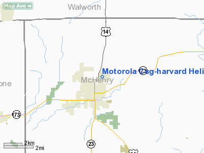
Motorola CSG-Harvard Heliport |
|
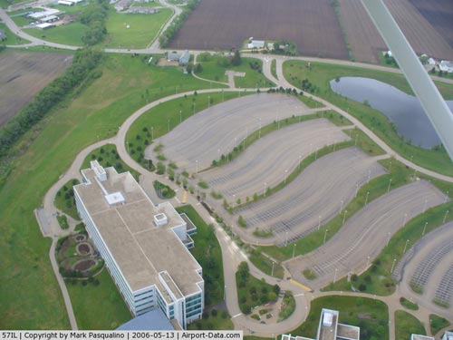 |
(Click on the photo to enlarge) |
Location
& QuickFacts
|
FAA
Information Effective: |
2007-12-20 |
|
Airport
Identifier: |
57IL |
|
Airport
Status: |
Operational |
|
Longitude/Latitude: |
088-36-13.0000W/42-26-17.0000N
-88.603611/42.438056 (Estimated) |
|
Elevation: |
1065 ft / 324.61 m (Estimated) |
|
Land: |
0 acres |
|
From nearest
city: |
2 nautical miles NE of Harvard, IL |
|
Location: |
Mc Henry County, IL |
|
Magnetic
Variation: |
01W (1995) |
Owner
& Manager
|
Ownership: |
Privately
owned |
|
Owner: |
Motorola Corporate Aviation |
|
Address: |
743 East Sumac Rd
Wheeling,
IL 60090 |
|
Phone
number: |
847-541-1014 |
|
Manager: |
Jim Myers |
|
Address: |
743 East Sumac Rd
Wheeling,
IL 60090 |
|
Phone
number: |
847-541-1014 |
Airport Operations
and Facilities
|
Airport
Use: |
Private |
|
Wind indicator: |
Yes |
|
Segmented
Circle: |
No |
|
Control
Tower: |
No |
|
Lighting
Schedule: |
RDO REQ
ACTVT PERIMETER LGTS RY H1 - 123.075. |
|
Sectional
chart: |
Chicago |
|
Region: |
AGL - Great Lakes |
|
Boundary
ARTCC: |
ZAU - Chicago |
|
Tie-in
FSS: |
IKK - Kankakee |
|
FSS on
Airport: |
No |
|
FSS Toll
Free: |
1-800-WX-BRIEF |
Airport
Communications
|
Runway Information
Helipad H1
|
Dimension: |
42 x 42 ft /
12.8 x 12.8 m |
|
Surface: |
CONC,
ROOFTOP. |
|
|
Runway H1 |
Runway |
|
Traffic
Pattern: |
Left |
Left |
|
Helipad H2
|
Dimension: |
40 x 40 ft /
12.2 x 12.2 m |
|
Surface: |
ASPH,
ROOFTOP. |
|
|
Runway H2 |
Runway |
|
Traffic
Pattern: |
Left |
Left |
|
Radio Navigation
Aids
|
ID |
Type |
Name |
Ch |
Freq |
Var |
Dist |
|
LVV |
NDB |
Lake Lawn |
|
404.00 |
00W |
15.7 nm |
|
JVL |
NDB |
Janesville |
|
375.00 |
03E |
22.1 nm |
|
DKB |
NDB |
Dekalb |
|
209.00 |
02W |
30.6 nm |
|
RA |
NDB |
Paser |
|
206.00 |
00E |
34.5 nm |
|
GM |
NDB |
Teels |
|
242.00 |
02W |
37.7 nm |
|
ME |
NDB |
Deana |
|
350.00 |
00E |
38.2 nm |
|
UES |
NDB |
Waukesha |
|
359.00 |
01W |
39.9 nm |
|
RYV |
NDB |
Rock River |
|
371.00 |
01W |
44.5 nm |
|
FEP |
NDB |
Freeport |
|
335.00 |
00E |
45.2 nm |
|
BL |
NDB |
Yanks |
|
260.00 |
02W |
49.3 nm |
|
MS |
NDB |
Monah |
|
400.00 |
00E |
49.8 nm |
|
BUU |
VOR/DME |
Burbun |
092X |
114.50 |
01W |
20.2 nm |
|
JVL |
VOR/DME |
Janesville |
090X |
114.30 |
03E |
23.4 nm |
|
RFD |
VOR/DME |
Rockford |
045X |
110.80 |
01E |
29.4 nm |
|
ENW |
VOR/DME |
Kenosha |
029X |
109.20 |
02W |
31.3 nm |
|
OBK |
VOR/DME |
Northbrook |
077X |
113.00 |
02W |
31.8 nm |
|
DPA |
VOR/DME |
Dupage |
021X |
108.40 |
02E |
34.8 nm |
|
HRK |
VOR/DME |
Horlick |
124X |
117.70 |
02W |
40.0 nm |
|
ORD |
VOR/DME |
Chicago O'hare |
086X |
113.90 |
02E |
41.2 nm |
|
LJT |
VOR/DME |
Timmerman |
072X |
112.50 |
02W |
47.5 nm |
|
PLL |
VOR/DME |
Polo |
049X |
111.20 |
03E |
49.9 nm |
|
BAE |
VORTAC |
Badger |
111X |
116.40 |
02E |
43.2 nm |
|
ORD |
VOT |
Chicago O'hare Intl |
|
112.00 |
|
41.4 nm |
|
MKE |
VOT |
Milwaukee |
|
109.00 |
|
43.8 nm |
Remarks
- PRVDD
OPNS CONDUCTED 80 DEG CLKWISE TO 100 DEG & 290 DEG CLKWISE TO 310
DEG USING PAD CENTER; APPROP.
MKD; MAINTAINED WIND INDICATOR; COMPLIANCE WITH 14 CFR PART 91.126(B)(2).
Motorola Csg-harvard Heliport
Address:
Mc Henry County, IL
Tel:
847-541-1014
Images
and information placed above are from
http://www.airport-data.com/airport/57IL/
We
thank them for the data!
| General
Info |
| Country |
United
States |
| State |
ILLINOIS
|
| FAA ID |
57IL |
| Latitude |
42-26-17.000N
|
| Longitude |
088-36-13.000W
|
| Elevation |
1065 feet
|
| Near City |
HARVARD
|
We don't guarantee the information is fresh and accurate. The data may
be wrong or outdated.
For more up-to-date information please refer to other sources.
|
|


