 |
|
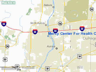
Mercy Center For Health Care Services Heliport |
|
|
Location
& QuickFacts
|
FAA
Information Effective: |
2007-12-20 |
|
Airport
Identifier: |
IL21 |
|
Airport
Status: |
Operational |
|
Longitude/Latitude: |
088-19-26.2600W/41-47-12.1040N
-88.323961/41.786696 (Estimated) |
|
Elevation: |
700 ft / 213.36 m (Estimated) |
|
Land: |
0 acres |
|
From nearest
city: |
1 nautical miles NW of Aurora, IL |
|
Location: |
Kane County, IL |
|
Magnetic
Variation: |
01W (1985) |
Owner
& Manager
|
Ownership: |
Privately
owned |
|
Owner: |
Mercy Ctr For Health Care Svs |
|
Address: |
1325 N. Highland Avenue
Aurora,
IL 60506 |
|
Phone
number: |
708-859-2222 |
|
Manager: |
John Scanlon |
|
Address: |
1325 N. Highland Avenue
Aurora,
IL 60506 |
|
Phone
number: |
708-859-2222 |
Airport Operations
and Facilities
|
Airport Use: |
Private
MEDICAL USE. |
|
Wind
indicator: |
Yes |
|
Segmented
Circle: |
No |
|
Control
Tower: |
No |
|
Lighting
Schedule: |
DUSK-DAWN |
|
Beacon
Color: |
Clear-Green-Yellow (heliport) |
|
Landing
fee charge: |
No |
|
Sectional
chart: |
Chicago |
|
Region: |
AGL - Great Lakes |
|
Boundary
ARTCC: |
ZAU - Chicago |
|
Tie-in
FSS: |
IKK - Kankakee |
|
FSS on
Airport: |
No |
|
FSS Toll
Free: |
1-800-WX-BRIEF |
Airport Services
|
Airframe
Repair: |
NONE |
|
Power
Plant Repair: |
NONE |
|
Runway Information
Helipad H1
|
Dimension: |
75 x 75 ft /
22.9 x 22.9 m |
|
Surface: |
ASPH, |
|
|
Runway H1 |
Runway |
|
Traffic
Pattern: |
Left |
Left |
|
Radio Navigation
Aids
|
ID |
Type |
Name |
Ch |
Freq |
Var |
Dist |
|
ME |
NDB |
Deana |
|
350.00 |
00E |
17.2 nm |
|
DKB |
NDB |
Dekalb |
|
209.00 |
02W |
19.3 nm |
|
HK |
NDB |
Ermin |
|
332.00 |
01W |
22.2 nm |
|
MX |
NDB |
Kedzi |
|
248.00 |
01W |
28.6 nm |
|
OIX |
NDB |
Ottawa |
|
266.00 |
01E |
34.9 nm |
|
VYS |
NDB |
Valley |
|
230.00 |
00W |
45.3 nm |
|
DPA |
VOR/DME |
Dupage |
021X |
108.40 |
02E |
6.3 nm |
|
ORD |
VOR/DME |
Chicago O'hare |
086X |
113.90 |
02E |
22.3 nm |
|
OBK |
VOR/DME |
Northbrook |
077X |
113.00 |
02W |
31.0 nm |
|
RFD |
VOR/DME |
Rockford |
045X |
110.80 |
01E |
47.2 nm |
|
IKK |
VOR/DME |
Kankakee |
053X |
111.60 |
00E |
47.8 nm |
|
JOT |
VORTAC |
Joliet |
070X |
112.30 |
02E |
14.4 nm |
|
CGT |
VORTAC |
Chicago Heights |
089X |
114.20 |
02E |
37.7 nm |
|
EON |
VORTAC |
Peotone |
079X |
113.20 |
02E |
39.3 nm |
|
ORD |
VOT |
Chicago O'hare Intl |
|
112.00 |
|
22.1 nm |
|
MDW |
VOT |
Chicago Midway |
|
111.00 |
|
25.6 nm |
Remarks
- (E111-1)
PER AGREEMENT WITH GADO 3, PLANNED SOD AREAS ARE IMPLEMENTED FOR EMERGENCY
LANDING AREAS; PROPOSED HELIPORT IS DESIGNED IN ACCORDANCE WITH SKETCH.
- PRVDD
ALL APCH/DEP RTE HELI OPNS ARE CONDD IN AN AREA FM 160-190, 350-010
DEG CLKWS USING TD PAD AS CNTR OF A COMPASS ROSE. TKOF/LNDG AREA APROPLY
MKD & LGTD, NON-OBSTG WIND INDCR MAINTD ADJ TO TKOF/LNDG AREA.
Mercy Center For Health Care Services
Heliport
Address:
Kane County, IL
Tel:
708-859-2222
Images
and information placed above are from
http://www.airport-data.com/airport/IL21/
We
thank them for the data!
| General
Info |
| Country |
United
States |
| State |
ILLINOIS
|
| FAA ID |
IL21 |
| Latitude |
41-47-12.104N
|
| Longitude |
088-19-26.260W
|
| Elevation |
700 feet
|
| Near City |
AURORA
|
We don't guarantee the information is fresh and accurate. The data may
be wrong or outdated.
For more up-to-date information please refer to other sources.
|
|


