 |
|
Memorial Hospital St Clair Heliport |
|
|
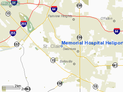
Location
& QuickFacts
|
FAA
Information Effective: |
2007-12-20 |
|
Airport
Identifier: |
60LL |
|
Airport
Status: |
Operational |
|
Longitude/Latitude: |
090-01-18.3800W/38-33-03.1810N
-90.021772/38.550884 (Estimated) |
|
Elevation: |
584 ft / 178.00 m (Surveyed) |
|
Land: |
0 acres |
|
From nearest
city: |
3 nautical miles NW of Belleville, IL |
|
Location: |
St Clair County, IL |
|
Magnetic
Variation: |
02E (1985) |
Owner
& Manager
|
Ownership: |
Privately
owned |
|
Owner: |
Protestant Mem Med Ctr, Inc. |
|
Address: |
4500 Memorial Dr
Belleville,
IL 62223 |
|
Phone
number: |
618-233-7750 |
|
Manager: |
Harry R. Maier |
|
Address: |
4500 Memorial Dr
Belleville,
IL 62223 |
|
Phone
number: |
618-233-7750 |
Airport
Operations and Facilities
|
Airport
Use: |
Private
MEDICAL USE. |
|
Wind indicator: |
Yes |
|
Segmented
Circle: |
No |
|
Control
Tower: |
No |
|
Lighting
Schedule: |
PHONE REQ
FOR ROTG BCN; PERIMETER & FLOOD LGTS CALL 618-233-7750. |
|
Beacon
Color: |
Clear-Green-Yellow (heliport) |
|
Sectional
chart: |
St Louis |
|
Region: |
AGL - Great Lakes |
|
Boundary
ARTCC: |
ZKC - Kansas City |
|
Tie-in
FSS: |
STL - Saint Louis |
|
FSS on
Airport: |
No |
|
FSS Toll
Free: |
1-800-WX-BRIEF |
|
Runway Information
Helipad H1
|
Dimension: |
42 x 42 ft /
12.8 x 12.8 m |
|
Surface: |
CONC, |
|
|
Runway H1 |
Runway |
|
Traffic
Pattern: |
Left |
Left |
|
Radio Navigation
Aids
|
ID |
Type |
Name |
Ch |
Freq |
Var |
Dist |
|
BL |
NDB |
Belleville |
|
362.00 |
02E |
13.5 nm |
|
CVM |
NDB |
Civic Memorial |
|
263.00 |
02E |
20.6 nm |
|
LM |
NDB |
Oblio |
|
338.00 |
00E |
26.0 nm |
|
FES |
NDB |
Festus |
|
269.00 |
01E |
27.4 nm |
|
SAR |
NDB |
Sparta |
|
239.00 |
01E |
28.7 nm |
|
LTD |
NDB |
Litchfield |
|
371.00 |
01E |
40.3 nm |
|
PJY |
NDB |
Pinckneyville |
|
215.00 |
00E |
46.5 nm |
|
SLO |
NDB |
Salem |
|
400.00 |
01W |
49.8 nm |
|
SKE |
TACAN |
Scott |
059X |
|
02E |
8.0 nm |
|
CSX |
VOR/DME |
Cardinal |
111Y |
116.45 |
00E |
20.0 nm |
|
TOY |
VORTAC |
Troy |
107X |
116.00 |
04E |
12.3 nm |
|
STL |
VORTAC |
St Louis |
121X |
117.40 |
01E |
28.5 nm |
|
ENL |
VORTAC |
Centralia |
097X |
115.00 |
04E |
41.3 nm |
|
FTZ |
VORTAC |
Foristell |
045X |
110.80 |
05E |
45.4 nm |
|
STL |
VOT |
St Louis Lambert |
|
111.00 |
|
19.9 nm |
|
SUS |
VOT |
Spirit Of St Louis |
|
112.20 |
|
30.3 nm |
Remarks
- PROVIDING
ALL APCH/DEP OPS 140-350 DEGS; TKOF/LNDG AREA APPROPRIATELY MKD; NON-OBSTRUCTING
WIND INDICATOR MAINTAINED.
Memorial Hospital St Clair Heliport
Address:
St Clair County, IL
Tel:
618-233-7750
Images
and information placed above are from
http://www.airport-data.com/airport/60LL/
We
thank them for the data!
We don't guarantee the information is fresh and accurate. The data may
be wrong or outdated.
For more up-to-date information please refer to other sources.
|
|


