 |
|
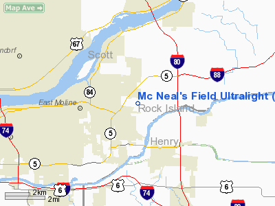
Mc Neal's Field Ultralight |
Location
& QuickFacts
|
FAA
Information Effective: |
2007-12-20 |
|
Airport
Identifier: |
2IL3 |
|
Airport
Status: |
Operational |
|
Longitude/Latitude: |
090-22-46.4620W/41-30-57.1220N
-90.379573/41.515867 (Estimated) |
|
Elevation: |
575 ft / 175.26 m (Estimated) |
|
Land: |
15 acres |
|
From nearest
city: |
3 nautical miles E of East Moline, IL |
|
Location: |
Rock Island County, IL |
|
Magnetic
Variation: |
01E (1985) |
Owner & Manager
|
Ownership: |
Privately
owned |
|
Owner: |
Dr George Mc Neal |
|
Address: |
Box 470
Hampton,
IL 61256 |
|
Phone
number: |
309-496-9350 |
|
Manager: |
Dr George Mc Neal |
|
Address: |
Box 470
Hampton,
IL 61256 |
|
Phone
number: |
309-792-3960 |
Airport Operations
and Facilities
|
Airport Use: |
Private |
|
Wind
indicator: |
Yes |
|
Segmented
Circle: |
No |
|
Control
Tower: |
No |
|
Landing
fee charge: |
No |
|
Sectional
chart: |
Chicago |
|
Region: |
AGL - Great Lakes |
|
Traffic
Pattern Alt: |
800 ft |
|
Boundary
ARTCC: |
ZAU - Chicago |
|
Tie-in
FSS: |
IKK - Kankakee |
|
FSS on
Airport: |
No |
|
FSS Toll
Free: |
1-800-WX-BRIEF |
Airport Services
|
Bottled
Oxygen: |
NONE |
|
Bulk Oxygen: |
NONE |
|
Runway Information
Runway 18/36
|
Dimension: |
2150 x 200 ft
/ 655.3 x 61.0 m |
|
Surface: |
TURF, Fair Condition |
|
|
Runway 18 |
Runway 36 |
|
Longitude: |
090-22-45.9500W |
090-22-45.4600W |
|
Latitude: |
41-31-07.6300N |
41-30-46.1200N |
|
Elevation: |
575.00 ft |
575.00 ft |
|
Traffic
Pattern: |
Left |
Left |
|
Markings: |
None, |
None, |
|
Runway End
Identifier: |
No |
No |
|
Centerline
Lights: |
No |
No |
|
Touchdown
Lights: |
No |
No |
|
Obstruction: |
25 ft rr, 400.0 ft from runway, 16:1 slope
to clear |
52 ft trees, 100.0 ft from runway, 100 ft right
of centerline, 1:1 slope to clear |
|
Radio Navigation
Aids
|
ID |
Type |
Name |
Ch |
Freq |
Var |
Dist |
|
CWI |
NDB |
Clinton |
|
377.00 |
01E |
19.0 nm |
|
EZI |
NDB |
Kewanee |
|
245.00 |
01E |
26.8 nm |
|
BOZ |
NDB |
Whiteside |
|
254.00 |
01E |
29.2 nm |
|
OQW |
NDB |
Maquoketa |
|
386.00 |
02E |
36.0 nm |
|
GBG |
VOR/DME |
Galesburg |
035X |
109.80 |
03E |
34.9 nm |
|
DDD |
VOR/DME |
Port City |
112X |
116.50 |
01E |
35.8 nm |
|
PLL |
VOR/DME |
Polo |
049X |
111.20 |
03E |
46.9 nm |
|
CVA |
VORTAC |
Davenport |
085X |
113.80 |
04E |
12.5 nm |
|
MZV |
VORTAC |
Moline |
091X |
114.40 |
05E |
16.5 nm |
|
BDF |
VORTAC |
Bradford |
094X |
114.70 |
00E |
41.7 nm |
|
DVN |
VOT |
Davenport Municipal |
|
111.80 |
|
10.9 nm |
Remarks
- HANGARS
IN PRIMARY & APCH SURFACE RWY 36.
- EXISTED
PRIOR TO 1959.
Based Aircraft
|
Aircraft
based on field: |
9 |
|
Single Engine
Airplanes: |
2 |
|
Ultralights: |
7 |
Operational Statistics
Time
Period: 1999-07-20 - 2000-07-18
|
Aircraft
Operations: |
58/Week |
|
General Aviation
Local: |
66.7% |
|
General Aviation
Itinerant: |
33.3% |
Mc Neal's Field Ultralight
Address:
Rock Island County, IL
Tel:
309-496-9350,
309-792-3960
Images
and information placed above are from
http://www.airport-data.com/airport/2IL3/
We
thank them for the data!
| General
Info |
| Country |
United
States |
| State |
ILLINOIS
|
| FAA ID |
2IL3 |
| Latitude |
41-30-57.122N
|
| Longitude |
090-22-46.462W
|
| Elevation |
575 feet
|
| Near City |
EAST MOLINE
|
We don't guarantee the information is fresh and accurate. The data may
be wrong or outdated.
For more up-to-date information please refer to other sources.
|
|


