 |
|
Location
& QuickFacts
|
FAA
Information Effective: |
2007-12-20 |
|
Airport
Identifier: |
94IL |
|
Airport
Status: |
Operational |
|
Longitude/Latitude: |
089-13-32.2580W/38-55-02.1650N
-89.225627/38.917268 (Estimated) |
|
Elevation: |
526 ft / 160.32 m (Estimated) |
|
Land: |
0 acres |
|
From nearest
city: |
2 nautical miles E of Mulberry Grove, IL |
|
Location: |
Fayette County, IL |
|
Magnetic
Variation: |
01E (1990) |
Owner
& Manager
|
Ownership: |
Privately
owned |
|
Owner: |
Harry E. Lutz |
|
Address: |
Rt 2 Box 390a
Mulberry Grove, IL 62262 |
|
Phone
number: |
618-425-3500 |
|
Manager: |
Harry E. Lutz |
|
Address: |
Rt 2 Box 390a
Mulberry Grove, IL 62262 |
|
Phone
number: |
618-425-3500 |
Airport Operations
and Facilities
|
Airport
Use: |
Private
PERSONAL USE. |
|
Segmented
Circle: |
No |
|
Control
Tower: |
No |
|
Sectional
chart: |
St Louis |
|
Region: |
AGL - Great Lakes |
|
Boundary
ARTCC: |
ZKC - Kansas City |
|
Tie-in
FSS: |
COU - Columbia |
|
FSS Toll
Free: |
1-800-WX-BRIEF |
|
Runway Information
Runway 09/27
|
Dimension: |
1840 x 70 ft
/ 560.8 x 21.3 m |
|
Surface: |
TURF, |
|
|
Runway 09 |
Runway 27 |
|
Traffic
Pattern: |
Left |
Left |
|
Obstruction: |
25 ft trees, 140.0 ft from runway |
|
|
Radio Navigation
Aids
|
ID |
Type |
Name |
Ch |
Freq |
Var |
Dist |
|
SLO |
NDB |
Salem |
|
400.00 |
01W |
20.4 nm |
|
LTD |
NDB |
Litchfield |
|
371.00 |
01E |
25.8 nm |
|
SYZ |
NDB |
Shelbyville |
|
365.00 |
01E |
34.4 nm |
|
BL |
NDB |
Belleville |
|
362.00 |
02E |
36.9 nm |
|
TAZ |
NDB |
Taylorville |
|
395.00 |
00E |
37.5 nm |
|
CVM |
NDB |
Civic Memorial |
|
263.00 |
02E |
38.9 nm |
|
FOA |
NDB |
Elm River |
|
353.00 |
00E |
39.1 nm |
|
SKE |
TACAN |
Scott |
059X |
|
02E |
36.9 nm |
|
VNN |
VOR/DME |
Mount Vernon |
085X |
113.80 |
02E |
38.7 nm |
|
VLA |
VORTAC |
Vandalia |
090X |
114.30 |
04E |
11.0 nm |
|
ENL |
VORTAC |
Centralia |
097X |
115.00 |
04E |
30.1 nm |
|
TOY |
VORTAC |
Troy |
107X |
116.00 |
04E |
34.2 nm |
|
BIB |
VORTAC |
Bible Grove |
027X |
109.00 |
03E |
34.8 nm |
Remarks
- PRVDD
OBSTNS ARE REMOVED/LOWERED OR THR DSPLCD TO PRVD 20:1 APCH CLNC.
Based
Aircraft
|
Aircraft
based on field: |
2 |
|
Single Engine
Airplanes: |
2 |
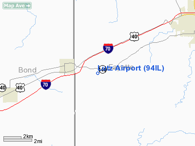
Lutz Airport
Address:
Fayette County, IL
Tel:
618-425-3500
Images
and information placed above are from
http://www.airport-data.com/airport/94IL/
We
thank them for the data!
| General
Info |
| Country |
United
States |
| State |
ILLINOIS
|
| FAA ID |
94IL |
| Latitude |
38-55-02.165N
|
| Longitude |
089-13-32.258W
|
| Elevation |
526 feet
|
| Near City |
MULBERRY
GROVE |
We don't guarantee the information is fresh and accurate. The data may
be wrong or outdated.
For more up-to-date information please refer to other sources.
|
|


