 |
|
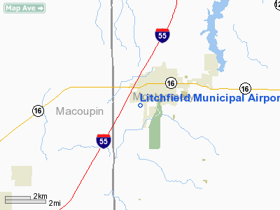
Litchfield Municipal Airport |
|
|
Location
& QuickFacts
|
FAA
Information Effective: |
2007-12-20 |
|
Airport
Identifier: |
3LF |
|
Airport
Status: |
Operational |
|
Longitude/Latitude: |
089-40-28.7000W/39-09-45.0000N
-89.674639/39.162500 (Estimated) |
|
Elevation: |
690 ft / 210.31 m (Surveyed) |
|
Land: |
415 acres |
|
From
nearest city: |
2 nautical miles SW of Litchfield, IL |
|
Location: |
Montgomery County, IL |
|
Magnetic Variation: |
01E (1990) |
Owner
& Manager
|
Ownership: |
Publicly
owned |
|
Owner: |
Litchfield Arpt Auth
DAN LAMB, CHAIRMAN. |
|
Address: |
1201 Us Route 66 South, P.o. Box 381
Litchfield, IL 62056 |
|
Phone
number: |
217-324-6507 |
|
Manager: |
Bill Stamper |
|
Address: |
1201us Route 66 South, P.o. Box 381
Litchfield, IL 62056 |
|
Phone number: |
217-556-4299 |
Airport Operations and Facilities
|
Airport
Use: |
Open
to public |
|
Wind
indicator: |
Yes |
|
Segmented Circle: |
Yes |
|
Control
Tower: |
No |
|
Lighting
Schedule: |
DUSK-DAWN
MIRL RWY 18/36 AND TAXIWAY C PRESET LOW INTST. INCREASE
INTST & ACTVT MIRL RWY 09/27, 18/36 PAPI, 09/27 VASI,
TAXIWAY LIGHTS AND REILS - CTAF. |
|
Beacon
Color: |
Clear-Green (lighted land airport) |
|
Landing
fee charge: |
No |
|
Sectional chart: |
St Louis |
|
Region: |
AGL - Great Lakes |
|
Traffic
Pattern Alt: |
800 ft |
|
Boundary
ARTCC: |
ZKC - Kansas City |
|
Tie-in
FSS: |
STL - Saint Louis |
|
FSS
on Airport: |
No |
|
FSS
Toll Free: |
1-800-WX-BRIEF |
|
NOTAMs
Facility: |
3LF (NOTAM-d service avaliable) |
|
Federal Agreements: |
NGY |
Airport Communications
|
CTAF: |
122.800 |
|
Unicom: |
122.800
|
Airport
Services
|
Fuel
available: |
100LLA
SELF SERV 100 LL FUEL AVAILABLE 24 HOURS. |
|
Airframe
Repair: |
MAJOR |
|
Power
Plant Repair: |
MAJOR |
|
Bottled
Oxygen: |
NONE |
|
Bulk
Oxygen: |
NONE |
|
Runway Information
Runway 09/27
|
Dimension: |
3901
x 75 ft / 1189.0 x 22.9 m |
|
Surface: |
ASPH, Good Condition |
|
Edge
Lights: |
Medium |
|
|
Runway 09 |
Runway 27 |
|
Longitude: |
089-41-01.9813W |
089-40-12.4590W |
|
Latitude: |
39-10-02.4914N |
39-10-02.4806N |
|
Elevation: |
682.00 ft |
690.00 ft |
|
Alignment: |
90 |
127 |
|
Traffic
Pattern: |
Right |
Left |
|
Markings: |
Non-precision instrument, Poor Condition
RWY MARKINGS OBLITERATED. |
Non-precision instrument, Poor Condition
RUNWAY MARKINGS OBLITERATED. |
|
Crossing
Height: |
25.00 ft |
57.00 ft |
|
VASI: |
2-box on left side
RY 09 VASI OTS INDEFLY. |
2-box on left side
OTS INDEFLY. |
|
Visual
Glide Angle: |
3.45° |
4.00° |
|
Runway
End Identifier: |
Yes
REIL RYS 09 & 27 OTS INDEFLY. |
Yes |
|
Centerline
Lights: |
No |
No |
|
Touchdown
Lights: |
No |
No |
|
Obstruction: |
14 ft road, 464.0 ft from runway, 289 ft left
of centerline, 18:1 slope to clear
APCH RATIO 33:1 TO RY END FM OVER C.O. |
17 ft road, 578.0 ft from runway, 303 ft left
of centerline, 22:1 slope to clear |
|
Runway 18/36
|
Dimension: |
4003
x 75 ft / 1220.1 x 22.9 m |
|
Surface: |
ASPH, Good Condition |
|
Edge
Lights: |
Medium |
|
|
Runway 18 |
Runway 36 |
|
Longitude: |
089-40-20.5071W |
089-40-20.3026W |
|
Latitude: |
39-09-47.6586N |
39-09-08.1001N |
|
Elevation: |
685.00 ft |
680.00 ft |
|
Alignment: |
127 |
127 |
|
Traffic
Pattern: |
Right |
Left |
|
Markings: |
Non-precision instrument, Good Condition |
Non-precision instrument, Good Condition |
|
Crossing
Height: |
23.00 ft |
25.00 ft |
|
VASI: |
2-light PAPI on left side |
2-light PAPI on left side |
|
Visual
Glide Angle: |
3.00° |
3.00° |
|
Runway
End Identifier: |
Yes |
Yes |
|
Centerline
Lights: |
No |
No |
|
Touchdown
Lights: |
No |
No |
|
Obstruction: |
62 ft tank, 2615.0 ft from runway, 190 ft left
of centerline, 38:1 slope to clear |
59 ft tree, 2680.0 ft from runway, 250 ft right
of centerline, 42:1 slope to clear |
|
Radio Navigation
Aids
|
ID |
Type |
Name |
Ch |
Freq |
Var |
Dist |
|
LTD |
NDB |
Litchfield |
|
371.00 |
01E |
0.2 nm |
|
CVM |
NDB |
Civic Memorial |
|
263.00 |
02E |
24.1 nm |
|
TAZ |
NDB |
Taylorville |
|
395.00 |
00E |
27.8 nm |
|
SP |
NDB |
Huskk |
|
382.00 |
01W |
36.9 nm |
|
SYZ |
NDB |
Shelbyville |
|
365.00 |
01E |
41.4 nm |
|
BL |
NDB |
Belleville |
|
362.00 |
02E |
42.1 nm |
|
LM |
NDB |
Oblio |
|
338.00 |
00E |
43.3 nm |
|
LQ |
NDB |
Licol |
|
375.00 |
01W |
45.2 nm |
|
SLO |
NDB |
Salem |
|
400.00 |
01W |
45.5 nm |
|
SKE |
TACAN |
Scott |
059X |
|
02E |
38.0 nm |
|
CSX |
VOR/DME |
Cardinal |
111Y |
116.45 |
00E |
40.4 nm |
|
IJX |
VOR/DME |
Jacksonville |
023X |
108.60 |
02E |
45.2 nm |
|
VLA |
VORTAC |
Vandalia |
090X |
114.30 |
04E |
24.2 nm |
|
TOY |
VORTAC |
Troy |
107X |
116.00 |
04E |
27.9 nm |
|
SPI |
VORTAC |
Spinner |
74X |
112.70 |
01W |
40.7 nm |
|
STL |
VORTAC |
St Louis |
121X |
117.40 |
01E |
41.9 nm |
|
CAP |
VORTAC |
Capital |
074X |
112.70 |
04E |
43.9 nm |
|
STL |
VOT |
St Louis Lambert |
|
111.00 |
|
40.7 nm |
Remarks
- AEROBATIC
AREA 1700 FT - 4200 FT MSL ABOVE ARPT.
Based
Aircraft
|
Aircraft
based on field: |
27 |
|
Single
Engine Airplanes: |
25 |
|
Multi
Engine Airplanes: |
1 |
|
Ultralights: |
1 |
Operational Statistics
Time Period: 2004-01-02 - 2004-12-31
|
Aircraft
Operations: |
193/Week |
|
Air
Taxi: |
4.0% |
|
General
Aviation Local: |
66.0% |
|
General
Aviation Itinerant: |
26.0% |
|
Military: |
4.0% |
Litchfield Municipal Airport
Address:
Montgomery County, IL
Tel:
217-324-6507,
217-556-4299
Images
and information placed above are from
http://www.airport-data.com/airport/3LF/
We
thank them for the data!
| General
Info |
| Country |
United
States |
| State |
ILLINOIS
|
| FAA ID |
3LF |
| Latitude |
39-09-44.970N
|
| Longitude |
089-40-28.694W
|
| Elevation |
690 feet
|
| Near City |
LITCHFIELD
|
We don't guarantee the information is fresh and accurate. The data may
be wrong or outdated.
For more up-to-date information please refer to other sources.
|
|


