|
|
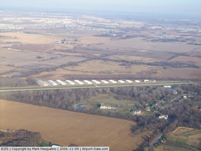
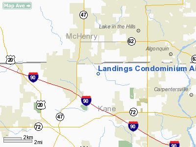
Landings Condominium Airport |
|
 |
(Click on the photo to enlarge) |
Location
& QuickFacts
|
FAA
Information Effective: |
2007-12-20 |
|
Airport
Identifier: |
82IS |
|
Airport
Status: |
Operational |
|
Longitude/Latitude: |
088-24-10.3040W/42-08-35.0880N
-88.402862/42.143080 (Estimated) |
|
Elevation: |
880 ft / 268.22 m (Estimated) |
|
Land: |
0 acres |
|
From
nearest city: |
2 nautical miles SE of Huntley, IL |
|
Location: |
Kane County, IL |
|
Magnetic Variation: |
00E (1980) |
Owner & Manager
|
Ownership: |
Privately owned |
|
Owner: |
Landings Condo Owners Assoc |
|
Address: |
Box 0697
Huntley, IL 60142 |
|
Phone number: |
847-669-3515 |
|
Manager: |
Lacoa Board Of Directors |
|
Address: |
Box 0697
Huntley, IL 60142 |
|
Phone number: |
847-669-3515 |
Airport
Operations and Facilities
|
Airport
Use: |
Private |
|
Wind
indicator: |
Yes |
|
Segmented Circle: |
Yes |
|
Control
Tower: |
No |
|
Lighting
Schedule: |
DUSK-DAWN
ACTVT HIRL RY 13/31; REIL RY 31 - 122.9. |
|
Beacon
Color: |
Clear-Green (lighted land airport) |
|
Landing fee charge: |
No |
|
Sectional chart: |
Chicago |
|
Region: |
AGL - Great Lakes |
|
Boundary ARTCC: |
ZAU - Chicago |
|
Tie-in FSS: |
IKK - Kankakee |
|
FSS on Airport: |
No |
|
FSS Toll Free: |
1-800-WX-BRIEF |
Airport Services
|
Airframe
Repair: |
NONE |
|
Power
Plant Repair: |
NONE |
|
Runway Information
Runway 13/31
|
Dimension: |
3150
x 50 ft / 960.1 x 15.2 m |
|
Surface: |
ASPH, |
|
Edge
Lights: |
High |
|
|
Runway 13 |
Runway 31 |
|
Traffic
Pattern: |
Left |
Right |
|
Displaced
threshold: |
0.00 ft |
600.00 ft |
|
Runway
End Identifier: |
|
Yes |
|
Radio Navigation
Aids
|
ID |
Type |
Name |
Ch |
Freq |
Var |
Dist |
|
DKB |
NDB |
Dekalb |
|
209.00 |
02W |
18.5
nm |
|
ME |
NDB |
Deana |
|
350.00 |
00E |
19.8
nm |
|
LVV |
NDB |
Lake
Lawn |
|
404.00 |
00W |
34.5
nm |
|
HK |
NDB |
Ermin |
|
332.00 |
01W |
35.9
nm |
|
RA |
NDB |
Paser |
|
206.00 |
00E |
39.4
nm |
|
MX |
NDB |
Kedzi |
|
248.00 |
01W |
40.0
nm |
|
JVL |
NDB |
Janesville |
|
375.00 |
03E |
40.1
nm |
|
GM |
NDB |
Teels |
|
242.00 |
02W |
48.8
nm |
|
DPA |
VOR/DME |
Dupage |
021X |
108.40 |
02E |
15.4
nm |
|
OBK |
VOR/DME |
Northbrook |
077X |
113.00 |
02W |
20.6
nm |
|
ORD |
VOR/DME |
Chicago
O'hare |
086X |
113.90 |
02E |
24.1
nm |
|
BUU |
VOR/DME |
Burbun |
092X |
114.50 |
01W |
33.1
nm |
|
ENW |
VOR/DME |
Kenosha |
029X |
109.20 |
02W |
34.5
nm |
|
RFD |
VOR/DME |
Rockford |
045X |
110.80 |
01E |
35.8
nm |
|
JVL |
VOR/DME |
Janesville |
090X |
114.30 |
03E |
39.9
nm |
|
HRK |
VOR/DME |
Horlick |
124X |
117.70 |
02W |
45.4
nm |
|
JOT |
VORTAC |
Joliet |
070X |
112.30 |
02E |
36.1
nm |
|
ORD |
VOT |
Chicago
O'hare Intl |
|
112.00 |
|
24.1
nm |
|
MDW |
VOT |
Chicago
Midway |
|
111.00 |
|
36.1
nm |
Remarks
- ALL
AERO OPNS CONDD IN ACCORDANCE WITH LTR OF AGRMT DTD 8-22-81, SIGNED
BY CHAD KOPPIE, OWNER OF KOPPIE ARPT & DWIGHT BALES, PRES, LANDINGS
AIRSTRIP CORP
Based
Aircraft
|
Aircraft
based on field: |
112 |
|
Single
Engine Airplanes: |
96 |
|
Multi
Engine Airplanes: |
12 |
|
Helicopters: |
4 |
Landings Condominium Airport
Address:
Kane County, IL
Tel:
847-669-3515
Images
and information placed above are from
http://www.airport-data.com/airport/82IS/
We
thank them for the data!
| General
Info |
| Country |
United
States |
| State |
ILLINOIS
|
| FAA ID |
82IS |
| Latitude |
42-08-35.088N
|
| Longitude |
088-24-10.304W
|
| Elevation |
880 feet
|
| Near City |
HUNTLEY
|
We don't guarantee the information is fresh and accurate. The data may
be wrong or outdated.
For more up-to-date information please refer to other sources.
|
|