 |
|
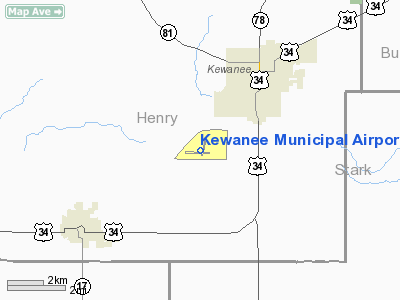
Kewanee Municipal Airport |
|
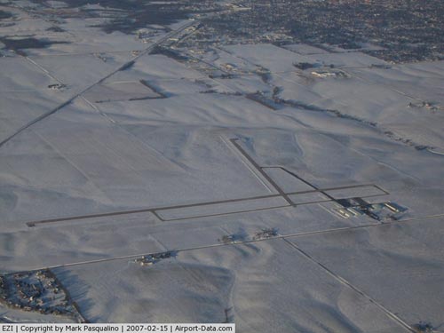 |
(Click on the photo to enlarge) |
|
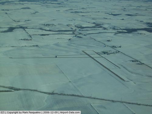 |
(Click on the photo to enlarge) |
Location
& QuickFacts
|
FAA
Information Effective: |
2007-12-20 |
|
Airport
Identifier: |
EZI |
|
Airport
Status: |
Operational |
|
Longitude/Latitude: |
089-57-49.9000W/41-12-18.7000N
-89.963861/41.205194 (Estimated) |
|
Elevation: |
858 ft / 261.52 m (Surveyed) |
|
Land: |
580 acres |
|
From
nearest city: |
3 nautical miles SW of Kewanee, IL |
|
Location: |
Henry County, IL |
|
Magnetic Variation: |
01E (1990) |
Owner & Manager
|
Ownership: |
Publicly owned |
|
Owner: |
Kewanee Airport Authority |
|
Address: |
3769 Midland Rd
Kewanee, IL 61443 |
|
Phone number: |
309-853-8671 |
|
Manager: |
Dale Lindstrom |
|
Address: |
3761 Midland Rd.
Kewanee, IL 61443 |
|
Phone number: |
309-853-8222 |
Airport
Operations and Facilities
|
Airport
Use: |
Open
to public |
|
Wind
indicator: |
Yes |
|
Segmented Circle: |
Yes |
|
Control
Tower: |
No |
|
Lighting
Schedule: |
DUSK-DAWN
MIRL RY 09/27 PRESET ON LOW INTST; TO INCR INTST & ACTVT
MIRL RY 01/19 & TWY LGTS - CTAF. |
|
Beacon
Color: |
Clear-Green (lighted land airport) |
|
Landing
fee charge: |
No |
|
Sectional chart: |
Chicago |
|
Region: |
AGL - Great Lakes |
|
Boundary
ARTCC: |
ZAU - Chicago |
|
Tie-in
FSS: |
IKK - Kankakee |
|
FSS
on Airport: |
No |
|
FSS
Toll Free: |
1-800-WX-BRIEF |
|
NOTAMs
Facility: |
IKK (NOTAM-d service avaliable) |
|
Federal Agreements: |
NGY |
Airport Communications
|
CTAF: |
122.800 |
|
Unicom: |
122.800
|
Airport
Services
|
Fuel
available: |
100LL |
|
Airframe
Repair: |
MAJOR |
|
Power
Plant Repair: |
MAJOR |
|
Bottled
Oxygen: |
NONE |
|
Bulk
Oxygen: |
NONE |
|
Runway Information
Runway 01/19
|
Dimension: |
3200
x 60 ft / 975.4 x 18.3 m |
|
Surface: |
ASPH, Good Condition |
|
Weight
Limit: |
Single wheel: 20000 lbs. |
|
Edge
Lights: |
Medium |
|
|
Runway 01 |
Runway 19 |
|
Longitude: |
089-57-45.1244W |
089-57-36.8812W |
|
Latitude: |
41-12-09.3926N |
41-12-40.3849N |
|
Elevation: |
855.00 ft |
837.00 ft |
|
Alignment: |
11 |
127 |
|
Traffic
Pattern: |
Left |
Left |
|
Markings: |
Non-precision instrument, Good Condition |
Non-precision instrument, Good Condition |
|
Obstruction: |
17 ft pline, 871.0 ft from runway, 62 ft right
of centerline, 39:1 slope to clear |
, 50:1 slope to clear |
|
Runway 09/27
|
Dimension: |
4500
x 75 ft / 1371.6 x 22.9 m |
|
Surface: |
ASPH, Good Condition |
|
Weight
Limit: |
Single wheel: 20000 lbs. |
|
Edge
Lights: |
Medium |
|
|
Runway 09 |
Runway 27 |
|
Longitude: |
089-58-25.7159W |
089-57-26.8586W |
|
Latitude: |
41-12-14.7577N |
41-12-13.9058N |
|
Elevation: |
854.00 ft |
856.00 ft |
|
Alignment: |
91 |
127 |
|
Traffic
Pattern: |
Left |
Left |
|
Markings: |
Non-precision instrument, Fair Condition |
Basic, Fair Condition |
|
Crossing
Height: |
29.00 ft |
26.00 ft |
|
VASI: |
pulsating/steady burning on left side
PSIL RYS 09 & 27 OTS INDEFLY. |
pulsating/steady burning on left side |
|
Visual
Glide Angle: |
3.50° |
3.00° |
|
Runway
End Identifier: |
|
No |
|
Centerline
Lights: |
|
No |
|
Touchdown
Lights: |
|
No |
|
Obstruction: |
61 ft pline, 1812.0 ft from runway, 94 ft left
of centerline, 26:1 slope to clear |
, 50:1 slope to clear |
|
Radio Navigation
Aids
|
ID |
Type |
Name |
Ch |
Freq |
Var |
Dist |
|
EZI |
NDB |
Kewanee |
|
245.00 |
01E |
0.3
nm |
|
BOZ |
NDB |
Whiteside |
|
254.00 |
01E |
31.5
nm |
|
VYS |
NDB |
Valley |
|
230.00 |
00W |
37.9
nm |
|
CTK |
NDB |
Canton |
|
236.00 |
02E |
38.8
nm |
|
PI |
NDB |
Tungg |
|
356.00 |
01E |
39.8
nm |
|
CWI |
NDB |
Clinton |
|
377.00 |
01E |
40.9
nm |
|
JZY |
NDB |
Macomb |
|
251.00 |
01E |
49.4
nm |
|
GBG |
VOR/DME |
Galesburg |
035X |
109.80 |
03E |
26.7
nm |
|
PLL |
VOR/DME |
Polo |
049X |
111.20 |
03E |
49.8
nm |
|
BDF |
VORTAC |
Bradford |
094X |
114.70 |
00E |
17.2
nm |
|
MZV |
VORTAC |
Moline |
091X |
114.40 |
05E |
31.2
nm |
|
PIA |
VORTAC |
Peoria |
099X |
115.20 |
04E |
32.5
nm |
|
CVA |
VORTAC |
Davenport |
085X |
113.80 |
04E |
38.2
nm |
|
DVN |
VOT |
Davenport
Municipal |
|
111.80 |
|
37.2
nm |
Remarks
- ULTRALIGHT
ACTIVITY ON & INVOF ARPT.
- PAEW
W OF RY 01/19 INDEFLY.
Based
Aircraft
|
Aircraft
based on field: |
26 |
|
Single
Engine Airplanes: |
20 |
|
Multi
Engine Airplanes: |
1 |
|
Ultralights: |
5 |
Operational Statistics
Time Period: 2004-01-02 - 2004-12-31
|
Aircraft
Operations: |
231/Week |
|
General
Aviation Local: |
66.7% |
|
General
Aviation Itinerant: |
33.0% |
|
Military: |
0.3% |
Kewanee Municipal Airport
Address:
Henry County, IL
Tel:
309-853-8671,
309-853-8222
Images
and information placed above are from
http://www.airport-data.com/airport/EZI/
We
thank them for the data!
| General
Info |
| Country |
United
States |
| State |
ILLINOIS
|
| FAA ID |
EZI |
| Latitude |
41-12-18.700N
|
| Longitude |
089-57-49.900W
|
| Elevation |
858 feet
|
| Near City |
KEWANEE
|
We don't guarantee the information is fresh and accurate. The data may
be wrong or outdated.
For more up-to-date information please refer to other sources.
|
|


