 |
|
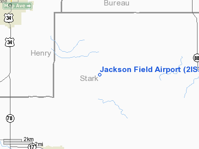
Location
& QuickFacts
|
FAA
Information Effective: |
2007-12-20 |
|
Airport
Identifier: |
2IS3 |
|
Airport
Status: |
Operational |
|
Longitude/Latitude: |
089-48-24.3710W/41-10-18.1330N
-89.806770/41.171704 (Estimated) |
|
Elevation: |
760 ft / 231.65 m (Estimated) |
|
Land: |
8 acres |
|
From
nearest city: |
1 nautical miles SE of Elmira, IL |
|
Location: |
Stark County, IL |
|
Magnetic Variation: |
01E (1985) |
Owner & Manager
|
Ownership: |
Privately owned |
|
Owner: |
David W. Jackson |
|
Address: |
Rt 2, Box 57
Toulon, IL 61483 |
|
Manager: |
David W. Jackson |
|
Address: |
Rt 2, Box 57
Toulon, IL 61483 |
Airport
Operations and Facilities
|
Airport
Use: |
Private |
|
Wind
indicator: |
Yes |
|
Segmented Circle: |
No |
|
Control
Tower: |
No |
|
Sectional chart: |
Chicago |
|
Region: |
AGL - Great Lakes |
|
Boundary
ARTCC: |
ZAU - Chicago |
|
Tie-in
FSS: |
IKK - Kankakee |
|
FSS
on Airport: |
No |
|
FSS
Toll Free: |
1-800-WX-BRIEF |
|
Runway Information
Runway 09/27
|
Dimension: |
1900
x 80 ft / 579.1 x 24.4 m |
|
Surface: |
TURF, |
|
|
Runway 09 |
Runway 27 |
|
Traffic
Pattern: |
Left |
Left |
|
Obstruction: |
|
60 ft bldg, 400.0 ft from runway |
|
Radio Navigation
Aids
|
ID |
Type |
Name |
Ch |
Freq |
Var |
Dist |
|
EZI |
NDB |
Kewanee |
|
245.00 |
01E |
7.1
nm |
|
VYS |
NDB |
Valley |
|
230.00 |
00W |
31.7
nm |
|
BOZ |
NDB |
Whiteside |
|
254.00 |
01E |
32.4
nm |
|
PI |
NDB |
Tungg |
|
356.00 |
01E |
35.4
nm |
|
CTK |
NDB |
Canton |
|
236.00 |
02E |
38.4
nm |
|
OIX |
NDB |
Ottawa |
|
266.00 |
01E |
44.5
nm |
|
CWI |
NDB |
Clinton |
|
377.00 |
01E |
45.9
nm |
|
GBG |
VOR/DME |
Galesburg |
035X |
109.80 |
03E |
31.7
nm |
|
PLL |
VOR/DME |
Polo |
049X |
111.20 |
03E |
49.4
nm |
|
BDF |
VORTAC |
Bradford |
094X |
114.70 |
00E |
9.9
nm |
|
PIA |
VORTAC |
Peoria |
099X |
115.20 |
04E |
29.6
nm |
|
MZV |
VORTAC |
Moline |
091X |
114.40 |
05E |
38.6
nm |
|
CVA |
VORTAC |
Davenport |
085X |
113.80 |
04E |
44.4
nm |
|
DVN |
VOT |
Davenport
Municipal |
|
111.80 |
|
43.9
nm |
Based
Aircraft
|
Aircraft
based on field: |
2 |
|
Single
Engine Airplanes: |
2 |
Jackson Field Airport
Address:
Stark County, IL
Tel:
Images
and information placed above are from
http://www.airport-data.com/airport/2IS3/
We
thank them for the data!
| General
Info |
| Country |
United
States |
| State |
ILLINOIS
|
| FAA ID |
2IS3 |
| Latitude |
41-10-18.133N
|
| Longitude |
089-48-24.371W
|
| Elevation |
760 feet
|
| Near City |
ELMIRA
|
We don't guarantee the information is fresh and accurate. The data may
be wrong or outdated.
For more up-to-date information please refer to other sources.
|
|


