 |
|
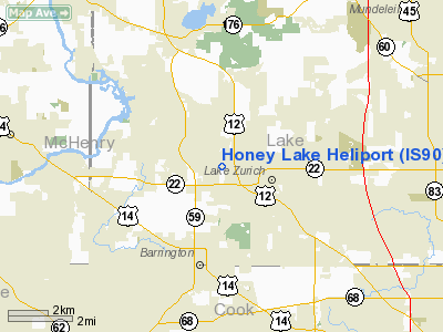
Location & QuickFacts
|
FAA Information Effective: |
2007-12-20 |
|
Airport Identifier: |
IS90 |
|
Airport Status: |
Operational |
|
Longitude/Latitude: |
088-07-08.2820W/42-11-55.0870N
-88.118967/42.198635 (Estimated) |
|
Elevation: |
860 ft / 262.13 m (Estimated) |
|
Land: |
0 acres |
|
From nearest city: |
1 nautical miles SW of Lake Zurick, IL |
|
Location: |
Lake County, IL |
|
Magnetic Variation: |
01W (1985) |
Owner
& Manager
|
Ownership: |
Privately
owned |
|
Owner: |
Edward Forman |
|
Address: |
1230 Honey Lake
Lake Zurich, IL 60047 |
|
Phone number: |
312-438-6219 |
|
Address: |
|
Airport Operations and Facilities
|
Airport
Use: |
Private |
|
Segmented Circle: |
No |
|
Control
Tower: |
No |
|
Sectional chart: |
Chicago |
|
Region: |
AGL - Great Lakes |
|
Boundary
ARTCC: |
ZAU - Chicago |
|
Tie-in
FSS: |
IKK - Kankakee |
|
FSS
on Airport: |
No |
|
FSS
Toll Free: |
1-800-WX-BRIEF |
|
Runway Information
Helipad H1
|
Dimension: |
10
x 10 ft / 3.0 x 3.0 m |
|
Surface: |
ASPH, |
|
|
Runway H1 |
Runway |
|
Traffic
Pattern: |
Left |
Left |
|
Radio Navigation
Aids
|
ID |
Type |
Name |
Ch |
Freq |
Var |
Dist |
|
ME |
NDB |
Deana |
|
350.00 |
00E |
14.5
nm |
|
RA |
NDB |
Paser |
|
206.00 |
00E |
30.7
nm |
|
DKB |
NDB |
Dekalb |
|
209.00 |
02W |
30.7
nm |
|
HK |
NDB |
Ermin |
|
332.00 |
01W |
31.5
nm |
|
MX |
NDB |
Kedzi |
|
248.00 |
01W |
33.5
nm |
|
LVV |
NDB |
Lake
Lawn |
|
404.00 |
00W |
36.7
nm |
|
GM |
NDB |
Teels |
|
242.00 |
02W |
42.8
nm |
|
JVL |
NDB |
Janesville |
|
375.00 |
03E |
48.0
nm |
|
OBK |
VOR/DME |
Northbrook |
077X |
113.00 |
02W |
7.6
nm |
|
ORD |
VOR/DME |
Chicago
O'hare |
086X |
113.90 |
02E |
15.9
nm |
|
DPA |
VOR/DME |
Dupage |
021X |
108.40 |
02E |
21.2
nm |
|
ENW |
VOR/DME |
Kenosha |
029X |
109.20 |
02W |
25.5
nm |
|
BUU |
VOR/DME |
Burbun |
092X |
114.50 |
01W |
30.6
nm |
|
HRK |
VOR/DME |
Horlick |
124X |
117.70 |
02W |
36.5
nm |
|
RFD |
VOR/DME |
Rockford |
045X |
110.80 |
01E |
48.1
nm |
|
JVL |
VOR/DME |
Janesville |
090X |
114.30 |
03E |
48.8
nm |
|
JOT |
VORTAC |
Joliet |
070X |
112.30 |
02E |
40.2
nm |
|
CGT |
VORTAC |
Chicago
Heights |
089X |
114.20 |
02E |
48.1
nm |
|
ORD |
VOT |
Chicago
O'hare Intl |
|
112.00 |
|
16.1
nm |
|
MDW |
VOT |
Chicago
Midway |
|
111.00 |
|
29.7
nm |
|
MKE |
VOT |
Milwaukee |
|
109.00 |
|
46.1
nm |
Remarks
- DUE
TO EXISTING OBSTNS IN ALL DIRS FROM THE HELIPAD.
Honey Lake Heliport
Address:
Lake County, IL
Tel:
312-438-6219
Images
and information placed above are from
http://www.airport-data.com/airport/IS90/
We
thank them for the data!
| General
Info |
| Country |
United
States |
| State |
ILLINOIS
|
| FAA ID |
IS90 |
| Latitude |
42-11-55.087N
|
| Longitude |
088-07-08.282W
|
| Elevation |
860 feet
|
| Near City |
LAKE ZURICK
|
We don't guarantee the information is fresh and accurate. The data may
be wrong or outdated.
For more up-to-date information please refer to other sources.
|
|


