 |
|
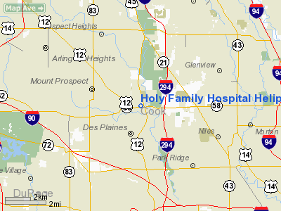
Holy Family Hospital Heliport |
Location
& QuickFacts
|
FAA
Information Effective: |
2007-12-20 |
|
Airport
Identifier: |
6IS5 |
|
Airport
Status: |
Operational |
|
Longitude/Latitude: |
087-53-29.2390W/42-03-18.1020N
-87.891455/42.055028 (Estimated) |
|
Elevation: |
650 ft / 198.12 m (Estimated) |
|
Land: |
0 acres |
|
From
nearest city: |
2 nautical miles N of Des Plaines, IL |
|
Location: |
Cook County, IL |
|
Magnetic Variation: |
01W (1985) |
Owner
& Manager
|
Ownership: |
Privately
owned |
|
Owner: |
Holy Family Hospital |
|
Address: |
100 North River Road
Des Plaines, IL 60016 |
|
Phone
number: |
312-297-1800 |
|
Manager: |
Raymond Fligg |
|
Address: |
100 North River Road
Des Plaines, IL 60016 |
|
Phone number: |
312-297-1800 |
Airport Operations and Facilities
|
Airport
Use: |
Private
MEDICAL USE. |
|
Segmented Circle: |
No |
|
Control
Tower: |
No |
|
Sectional chart: |
Chicago |
|
Region: |
AGL - Great Lakes |
|
Boundary
ARTCC: |
ZAU - Chicago |
|
Tie-in
FSS: |
IKK - Kankakee |
|
FSS
on Airport: |
No |
|
FSS
Toll Free: |
1-800-WX-BRIEF |
|
Runway Information
Helipad H1
|
Dimension: |
1000
x 350 ft / 304.8 x 106.7 m |
|
Surface: |
CONC, |
|
|
Runway H1 |
Runway |
|
Traffic
Pattern: |
Left |
Left |
|
Radio Navigation
Aids
|
ID |
Type |
Name |
Ch |
Freq |
Var |
Dist |
|
ME |
NDB |
Deana |
|
350.00 |
00E |
8.0
nm |
|
HK |
NDB |
Ermin |
|
332.00 |
01W |
20.3
nm |
|
MX |
NDB |
Kedzi |
|
248.00 |
01W |
20.9
nm |
|
DKB |
NDB |
Dekalb |
|
209.00 |
02W |
37.2
nm |
|
RA |
NDB |
Paser |
|
206.00 |
00E |
37.7
nm |
|
LVV |
NDB |
Lake
Lawn |
|
404.00 |
00W |
49.7
nm |
|
ORD |
VOR/DME |
Chicago
O'hare |
086X |
113.90 |
02E |
4.1
nm |
|
OBK |
VOR/DME |
Northbrook |
077X |
113.00 |
02W |
10.4
nm |
|
DPA |
VOR/DME |
Dupage |
021X |
108.40 |
02E |
22.8
nm |
|
ENW |
VOR/DME |
Kenosha |
029X |
109.20 |
02W |
32.8
nm |
|
BUU |
VOR/DME |
Burbun |
092X |
114.50 |
01W |
42.3
nm |
|
HRK |
VOR/DME |
Horlick |
124X |
117.70 |
02W |
42.6
nm |
|
CGT |
VORTAC |
Chicago
Heights |
089X |
114.20 |
02E |
35.8
nm |
|
JOT |
VORTAC |
Joliet |
070X |
112.30 |
02E |
36.1
nm |
|
EON |
VORTAC |
Peotone |
079X |
113.20 |
02E |
47.4
nm |
|
ORD |
VOT |
Chicago
O'hare Intl |
|
112.00 |
|
4.4
nm |
|
MDW |
VOT |
Chicago
Midway |
|
111.00 |
|
17.3
nm |
Remarks
- ALL
OPNS ARE CONDD FM 2250-260 DEG & FM 280-330 DEG, AREA IS MKD, WIND
INDCR IS MAINTD, UNAUTHORIZED PERSONS/VEHICLES ARE RESTRAINED FM AREA.
Holy Family Hospital Heliport
Address:
Cook County, IL
Tel:
312-297-1800
Images
and information placed above are from
http://www.airport-data.com/airport/6IS5/
We
thank them for the data!
| General
Info |
| Country |
United
States |
| State |
ILLINOIS
|
| FAA ID |
6IS5 |
| Latitude |
42-03-18.102N
|
| Longitude |
087-53-29.239W
|
| Elevation |
650 feet
|
| Near City |
DES PLAINES
|
We don't guarantee the information is fresh and accurate. The data may
be wrong or outdated.
For more up-to-date information please refer to other sources.
|
|


