 |
|
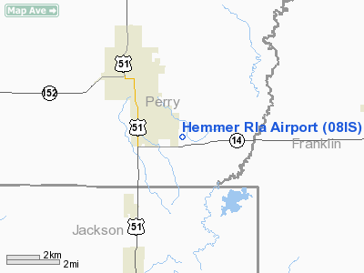
Location
& QuickFacts
|
FAA
Information Effective: |
2007-12-20 |
|
Airport
Identifier: |
08IS |
|
Airport
Status: |
Operational |
|
Longitude/Latitude: |
089-12-10.2920W/37-58-40.1810N
-89.202859/37.977828 (Estimated) |
|
Elevation: |
400 ft / 121.92 m (Estimated) |
|
Land: |
0 acres |
|
From
nearest city: |
2 nautical miles SE of Du Quoin, IL |
|
Location: |
Perry County, IL |
|
Magnetic Variation: |
01E (1985) |
Owner
& Manager
|
Ownership: |
Privately
owned |
|
Owner: |
Wilbur M. Hemmer |
|
Address: |
829 Blacksop Road
Du Quoin, IL 62832-3831 |
|
Phone number: |
618-542-2791 |
|
Address: |
|
Airport Operations and Facilities
|
Airport Use: |
Private |
|
Wind indicator: |
Yes |
|
Segmented Circle: |
No |
|
Control Tower: |
No |
|
Landing fee charge: |
No |
|
Sectional chart: |
St Louis |
|
Region: |
AGL - Great Lakes |
|
Boundary ARTCC: |
ZKC - Kansas City |
|
Tie-in FSS: |
COU - Columbia |
|
FSS on Airport: |
No |
|
FSS Toll Free: |
1-800-WX-BRIEF |
Airport Services
|
Airframe
Repair: |
NONE |
|
Power
Plant Repair: |
NONE |
|
Runway Information
Runway 18/36
|
Dimension: |
1320
x 70 ft / 402.3 x 21.3 m |
|
Surface: |
TURF, |
|
|
Runway 18 |
Runway 36 |
|
Traffic
Pattern: |
Left |
Right |
|
Radio Navigation
Aids
|
ID |
Type |
Name |
Ch |
Freq |
Var |
Dist |
|
PJY |
NDB |
Pinckneyville |
|
215.00 |
00E |
7.6
nm |
|
SAR |
NDB |
Sparta |
|
239.00 |
01E |
25.7
nm |
|
HSB |
NDB |
Harrisburg-raleigh |
|
230.00 |
00E |
32.8
nm |
|
BL |
NDB |
Belleville |
|
362.00 |
02E |
39.2
nm |
|
SLO |
NDB |
Salem |
|
400.00 |
01W |
41.6
nm |
|
FWC |
NDB |
Wayne
County |
|
257.00 |
01E |
44.6
nm |
|
SKE |
TACAN |
Scott |
059X |
|
02E |
45.8
nm |
|
MWA |
VOR/DME |
Marion |
041X |
110.40 |
04E |
16.2
nm |
|
VNN |
VOR/DME |
Mount
Vernon |
085X |
113.80 |
02E |
29.7
nm |
|
CGI |
VOR/DME |
Cape
Girardeau |
076X |
112.90 |
01E |
48.4
nm |
|
ENL |
VORTAC |
Centralia |
097X |
115.00 |
04E |
26.7
nm |
Based
Aircraft
|
Aircraft
based on field: |
1 |
|
Single
Engine Airplanes: |
1 |
Hemmer Rla Airport
Address:
Perry County, IL
Tel:
618-542-2791
Images
and information placed above are from
http://www.airport-data.com/airport/08IS/
We
thank them for the data!
| General
Info |
| Country |
United
States |
| State |
ILLINOIS
|
| FAA ID |
08IS |
| Latitude |
37-58-40.181N
|
| Longitude |
089-12-10.292W
|
| Elevation |
400 feet
|
| Near City |
DU QUOIN
|
We don't guarantee the information is fresh and accurate. The data may
be wrong or outdated.
For more up-to-date information please refer to other sources.
|
|


