 |
|
|
|
|
|
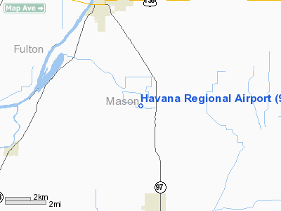
Location
& QuickFacts
|
FAA
Information Effective: |
2007-12-20 |
|
Airport
Identifier: |
9I0 |
|
Airport
Status: |
Operational |
|
Longitude/Latitude: |
090-01-22.3182W/40-13-19.1500N
-90.022866/40.221986 (Estimated) |
|
Elevation: |
499 ft / 152.10 m (Surveyed) |
|
Land: |
160 acres |
|
From
nearest city: |
5 nautical miles SE of Havana, IL |
|
Location: |
Mason County, IL |
|
Magnetic Variation: |
01E (1985) |
Owner
& Manager
|
Ownership: |
Publicly
owned |
|
Owner: |
Havana Regional Port District |
|
Address: |
509 East Laurel Ave
Havana, IL 62644 |
|
Phone
number: |
309-543-6005 |
|
Manager: |
Robert Tapscott |
|
Address: |
17970 County Road 1100 N.
Havana, IL 62655 |
|
Phone number: |
309-971-3554 |
Airport Operations and Facilities
|
Airport
Use: |
Open
to public |
|
Wind
indicator: |
Yes |
|
Segmented Circle: |
No |
|
Control
Tower: |
No |
|
Lighting
Schedule: |
DUSK-DAWN |
|
Beacon
Color: |
Clear-Green (lighted land airport) |
|
Sectional chart: |
Chicago |
|
Region: |
AGL - Great Lakes |
|
Boundary
ARTCC: |
ZAU - Chicago |
|
Tie-in
FSS: |
IKK - Kankakee |
|
FSS
on Airport: |
No |
|
FSS
Toll Free: |
1-800-WX-BRIEF |
|
NOTAMs
Facility: |
IKK (NOTAM-d service avaliable) |
|
Federal Agreements: |
NPY |
Airport Communications
|
Runway Information
Runway 09/27
|
Dimension: |
2235
x 100 ft / 681.2 x 30.5 m |
|
Surface: |
TURF, Good Condition |
|
Edge
Lights: |
Low |
|
|
Runway 09 |
Runway 27 |
|
Longitude: |
090-01-36.7264W |
090-01-07.9100W |
|
Latitude: |
40-13-19.1500N |
40-13-19.1500N |
|
Elevation: |
0.00 ft |
499.00 ft |
|
Traffic
Pattern: |
Left |
Left |
|
Radio Navigation
Aids
|
ID |
Type |
Name |
Ch |
Freq |
Var |
Dist |
|
CTK |
NDB |
Canton |
|
236.00 |
02E |
20.8
nm |
|
LQ |
NDB |
Licol |
|
375.00 |
01W |
26.8
nm |
|
SP |
NDB |
Huskk |
|
382.00 |
01W |
29.6
nm |
|
PI |
NDB |
Tungg |
|
356.00 |
01E |
30.3
nm |
|
JZY |
NDB |
Macomb |
|
251.00 |
01E |
30.4
nm |
|
AAA |
NDB |
Abraham |
|
329.00 |
00E |
31.7
nm |
|
PPQ |
NDB |
Pittsfield |
|
344.00 |
02E |
49.5
nm |
|
IJX |
VOR/DME |
Jacksonville |
023X |
108.60 |
02E |
28.6
nm |
|
GBG |
VOR/DME |
Galesburg |
035X |
109.80 |
03E |
46.9
nm |
|
CAP |
VORTAC |
Capital |
074X |
112.70 |
04E |
27.0
nm |
|
SPI |
VORTAC |
Spinner |
74X |
112.70 |
01W |
27.9
nm |
|
PIA |
VORTAC |
Peoria |
099X |
115.20 |
04E |
29.5
nm |
Remarks
- 9
FT CROPS E OF RY 27 THLD - SEASONAL.
Based
Aircraft
|
Aircraft
based on field: |
10 |
|
Single
Engine Airplanes: |
8 |
|
Ultralights: |
2 |
Operational Statistics
Time Period: 2006-01-01 - 2006-12-31
|
Aircraft
Operations: |
21/Week |
|
General
Aviation Local: |
92.6% |
|
General
Aviation Itinerant: |
7.4% |
Havana Regional Airport
Address:
Mason County, IL
Tel:
309-543-6005,
309-971-3554
Images
and information placed above are from
http://www.airport-data.com/airport/9I0/
We
thank them for the data!
| General
Info |
| Country |
United
States |
| State |
ILLINOIS
|
| FAA ID |
9I0 |
| Latitude |
40-13-16.158N
|
| Longitude |
090-01-22.417W
|
| Elevation |
499 feet
|
| Near City |
HAVANA
|
We don't guarantee the information is fresh and accurate. The data may
be wrong or outdated.
For more up-to-date information please refer to other sources.
|
|


