 |
|
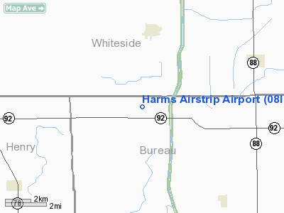
Location
& QuickFacts
|
FAA
Information Effective: |
2007-12-20 |
|
Airport
Identifier: |
08IL |
|
Airport
Status: |
Operational |
|
Longitude/Latitude: |
089-47-38.3780W/41-34-37.1180N
-89.793994/41.576977 (Estimated) |
|
Elevation: |
643 ft / 195.99 m (Estimated) |
|
Land: |
0 acres |
|
From
nearest city: |
3 nautical miles S of Tampico, IL |
|
Location: |
Whiteside County, IL |
|
Magnetic Variation: |
01E (1985) |
Owner & Manager
|
Ownership: |
Privately owned |
|
Owner: |
Donald W. Harms |
|
Address: |
Rt 1
Tampico, IL 61283 |
|
Phone number: |
319-340-3188 |
|
Manager: |
Donald W. Harms |
|
Address: |
Rt 1
Tampico, IL 61283 |
|
Phone number: |
815-438-3310 |
Airport
Operations and Facilities
|
Airport
Use: |
Private |
|
Wind
indicator: |
Yes |
|
Segmented Circle: |
No |
|
Control
Tower: |
No |
|
Sectional chart: |
Chicago |
|
Region: |
AGL - Great Lakes |
|
Boundary
ARTCC: |
ZAU - Chicago |
|
Tie-in
FSS: |
IKK - Kankakee |
|
FSS
Toll Free: |
1-800-WX-BRIEF |
|
Runway Information
Runway 09/27
|
Dimension: |
2200
x 75 ft / 670.6 x 22.9 m |
|
Surface: |
TURF, |
|
|
Runway 09 |
Runway 27 |
|
Traffic
Pattern: |
Left |
Left |
|
Radio Navigation
Aids
|
ID |
Type |
Name |
Ch |
Freq |
Var |
Dist |
|
BOZ |
NDB |
Whiteside |
|
254.00 |
01E |
8.1
nm |
|
EZI |
NDB |
Kewanee |
|
245.00 |
01E |
23.8
nm |
|
CWI |
NDB |
Clinton |
|
377.00 |
01E |
28.3
nm |
|
VYS |
NDB |
Valley |
|
230.00 |
00W |
32.0
nm |
|
FEP |
NDB |
Freeport |
|
335.00 |
00E |
41.3
nm |
|
OIX |
NDB |
Ottawa |
|
266.00 |
01E |
44.2
nm |
|
PLL |
VOR/DME |
Polo |
049X |
111.20 |
03E |
26.3
nm |
|
RFD |
VOR/DME |
Rockford |
045X |
110.80 |
01E |
47.2
nm |
|
GBG |
VOR/DME |
Galesburg |
035X |
109.80 |
03E |
48.1
nm |
|
BDF |
VORTAC |
Bradford |
094X |
114.70 |
00E |
26.7
nm |
|
CVA |
VORTAC |
Davenport |
085X |
113.80 |
04E |
32.0
nm |
|
MZV |
VORTAC |
Moline |
091X |
114.40 |
05E |
41.0
nm |
|
DVN |
VOT |
Davenport
Municipal |
|
111.80 |
|
35.6
nm |
Remarks
- PROVIDED
ANY OBST ON RWY APCH SLOPE SFCS REMOVED/ LOWERED OR THLD DSPLCD AND
MKD TO PROVIDE MINIMUM 20:1 APCH SFC CLNC OVER OBST.
Based
Aircraft
|
Aircraft
based on field: |
1 |
|
Single
Engine Airplanes: |
1 |
Harms Airstrip Airport
Address:
Whiteside County, IL
Tel:
319-340-3188,
815-438-3310
Images
and information placed above are from
http://www.airport-data.com/airport/08IL/
We
thank them for the data!
| General
Info |
| Country |
United
States |
| State |
ILLINOIS
|
| FAA ID |
08IL |
| Latitude |
41-34-37.118N
|
| Longitude |
089-47-38.378W
|
| Elevation |
643 feet
|
| Near City |
TAMPICO
|
We don't guarantee the information is fresh and accurate. The data may
be wrong or outdated.
For more up-to-date information please refer to other sources.
|
|


