 |
|
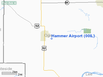
Location
& QuickFacts
|
FAA
Information Effective: |
2007-12-20 |
|
Airport
Identifier: |
00IL |
|
Airport
Status: |
Operational |
|
Longitude/Latitude: |
089-33-37.3980W/41-58-42.1080N
-89.560388/41.978363 (Estimated) |
|
Elevation: |
840 ft / 256.03 m (Estimated) |
|
Land: |
20 acres |
|
From
nearest city: |
1 nautical miles SE of Polo, IL |
|
Location: |
Ogle County, IL |
|
Magnetic Variation: |
01E (1985) |
Owner
& Manager
|
Ownership: |
Privately
owned |
|
Owner: |
Ronald Hammer |
|
Address: |
11658 W Judson Rd
Polo, IL 61064 |
|
Phone
number: |
815-622-9000 |
|
Manager: |
Ronald Hammer |
|
Address: |
10924 Hoover Rd
Rock Falls, IL 61071 |
|
Phone number: |
815-622-9000 |
Airport Operations and Facilities
|
Airport Use: |
Private |
|
Wind indicator: |
No |
|
Segmented Circle: |
No |
|
Control Tower: |
No |
|
Landing fee charge: |
No |
|
Sectional chart: |
Chicago |
|
Region: |
AGL - Great Lakes |
|
Traffic Pattern Alt: |
800 ft |
|
Boundary ARTCC: |
ZAU - Chicago |
|
Tie-in FSS: |
IKK - Kankakee |
|
FSS on Airport: |
No |
|
FSS Toll Free: |
1-800-WX-BRIEF |
Airport
Communications
|
Runway Information
Runway 18/36
|
Dimension: |
2500
x 100 ft / 762.0 x 30.5 m |
|
Surface: |
TURF, Fair Condition |
|
|
Runway 18 |
Runway 36 |
|
Traffic
Pattern: |
Left |
Left |
|
Displaced
threshold: |
290.00 ft
& RWY 36 DSPLCD THR MKD WITH TIRES. |
350.00 ft |
|
Runway
End Identifier: |
No |
No |
|
Centerline
Lights: |
No |
No |
|
Touchdown
Lights: |
No |
No |
|
Obstruction: |
15 ft road, 10.0 ft from runway
APCH RATIO 20:1 AT DSPLCD THR. |
18 ft road, 10.0 ft from runway
APCH RATIO 20:1 AT DSPLCD THR. |
|
Radio Navigation
Aids
|
ID |
Type |
Name |
Ch |
Freq |
Var |
Dist |
|
FEP |
NDB |
Freeport |
|
335.00 |
00E |
16.1
nm |
|
BOZ |
NDB |
Whiteside |
|
254.00 |
01E |
19.0
nm |
|
CWI |
NDB |
Clinton |
|
377.00 |
01E |
35.5
nm |
|
DKB |
NDB |
Dekalb |
|
209.00 |
02W |
38.2
nm |
|
VYS |
NDB |
Valley |
|
230.00 |
00W |
41.8
nm |
|
JVL |
NDB |
Janesville |
|
375.00 |
03E |
44.7
nm |
|
OIX |
NDB |
Ottawa |
|
266.00 |
01E |
48.7
nm |
|
PLL |
VOR/DME |
Polo |
049X |
111.20 |
03E |
1.8
nm |
|
RFD |
VOR/DME |
Rockford |
045X |
110.80 |
01E |
21.9
nm |
|
JVL |
VOR/DME |
Janesville |
090X |
114.30 |
03E |
40.3
nm |
|
CVA |
VORTAC |
Davenport |
085X |
113.80 |
04E |
44.4
nm |
|
BDF |
VORTAC |
Bradford |
094X |
114.70 |
00E |
49.2
nm |
Remarks
- DITCH
AT APCH END RWY 36.
Operational Statistics
Time Period: 1993-08-28 - 1994-08-27
|
Aircraft
Operations: |
29/Week |
|
General
Aviation Local: |
33.3% |
|
General
Aviation Itinerant: |
66.7% |
Hammer Airport
Address:
Ogle County, IL
Tel:
815-622-9000
Images
and information placed above are from
http://www.airport-data.com/airport/00IL/
We
thank them for the data!
| General
Info |
| Country |
United
States |
| State |
ILLINOIS
|
| FAA ID |
00IL |
| Latitude |
41-58-42.108N
|
| Longitude |
089-33-37.398W
|
| Elevation |
840 feet
|
| Near City |
POLO |
We don't guarantee the information is fresh and accurate. The data may
be wrong or outdated.
For more up-to-date information please refer to other sources.
|
|


