|
|
Greater Peoria Regional Airport |
| General Wayne A. Downing Peoria International Airport |
| IATA: PIA â ICAO: KPIA â FAA LID: PIA |
| Summary |
| Airport type |
Public |
| Operator |
Greater Peoria Airport Authority |
| Serves |
Peoria, Illinois |
| Location |
Limestone Township, Peoria County, near Peoria, Illinois |
| Elevation AMSL |
660 ft / 201 m |
| Coordinates |
40°39â²51â³N 089°41â²36â³W / 40.66417°N 89.69333°W / 40.66417; -89.69333Coordinates: 40°39â²51â³N 089°41â²36â³W / 40.66417°N 89.69333°W / 40.66417; -89.69333 |
| Website |
www.FlyPIA.com |
| Runways |
| Direction |
Length |
Surface |
| ft |
m |
| 13/31 |
10,104 |
3,080 |
Concrete |
| 4/22 |
8,003 |
2,439 |
Asphalt |
| Statistics (2008) |
| Aircraft operations |
53,305 |
| Based aircraft |
87 |
| Sources: Airport and FAA |
General Wayne A. Downing Peoria International Airport (IATA: PIA, ICAO: KPIA, FAA LID: PIA) is a joint civil-military public use airport located four nautical miles (7 km) west of the central business district of Peoria, a city in Peoria County, Illinois, United States. The airport is on the northwest edge of Bartonville, near Bellevue. It was formerly known as the Greater Peoria Regional Airport. It is often referred to simply as Peoria International Airport by the airport authority. History
On May 19, 1932 the citizens of Peoria voted to have an airport. On 195 acres (0.8 km²), American Airways (now American Airlines) and Chicago and Southern Airlines brought in airmail and passenger service on 4 shale-surfaced runways. The land was purchased by 261 Peoria businessmen who formed the Peoria Airport, Inc. It was turned over to the Peoria Park District in 1937, and then to newly-formed The Metropolitan Airport Authority of Peoria in 1950.
On April 25, 2007 the Greater Peoria Airport Authority announced that a new 9 gate terminal will be built and the older terminal would be demolished. On October 10, 2008, the airport was renamed "General Wayne A. Downing Peoria International Airport" during a groundbreaking ceremony attended by Ross Perot, friend of the late Wayne A. Downing.
National Guard
The airport is home to the 182d Airlift Wing, Illinois Air National Guard. This Air National Guard unit is operationally-gained by the Air Mobility Command (AMC) and consists of Lockheed C-130H Hercules aircraft. The airport is also home to the Illinois Army National Guard's Army Aviation Support Facility #3 and 1st Battalion, 106th Aviation Regiment, currently operating the Boeing CH-47 "Chinook" helicopter.
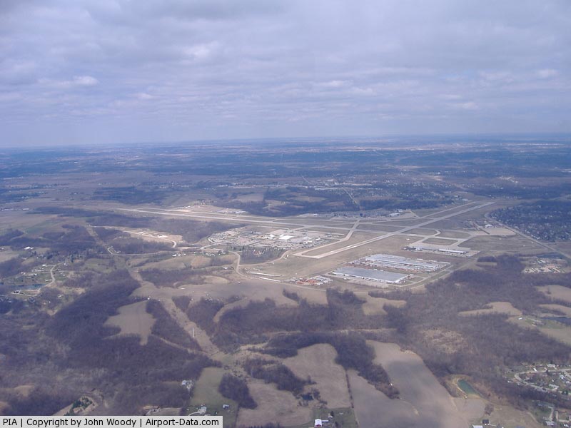
Facilities and aircraft
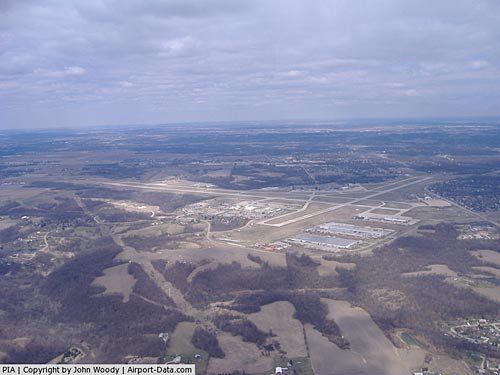
Peoria International Airport covers an area of 3,800 acres (1,538 ha) at an elevation of 660 feet (201 m) above mean sea level. It has two runways: 13/31 is 10,104 by 150 feet (3,080 x 46 m) with a concrete surface; 4/22 is 8,003 by 150 feet (2,439 x 46 m) with an asphalt pavement.
For the 12-month period ending July 31, 2008, the airport had 53,305 aircraft operations, an average of 146 per day: 43% general aviation, 31% air taxi, 19% military and 8% scheduled commercial. At that time there were 87 aircraft based at this airport: 48% single-engine, 21% multi-engine, 18% military, 8% jet, and 5% helicopter.
Airlines and destinations
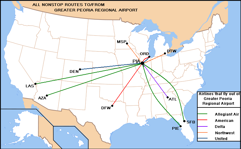
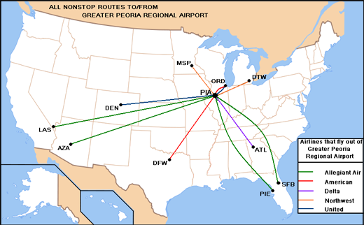 | |
Destinations from PIA (as of June 2008) |
As of January 2010, Peoria International Airport is served by 5 airlines. Allegiant Air is the only airline to offer larger jets. Delta Air Lines, United Airlines and American Eagle offer flights in smaller regional jets. As of July 2010, all civilian passenger service is domestic, though at various times there has been talk of adding international service.
| Airlines |
Destinations |
| Allegiant Air |
Las Vegas, Phoenix-Mesa, St. Petersburg-Clearwater |
| AmericanConnection operated by Chautauqua Airlines |
Chicago-O'Hare |
| American Eagle |
Dallas/Fort Worth |
| Delta Connection operated by Mesaba Airlines |
Minneapolis/St. Paul |
| Delta Connection operated by Pinnacle Airlines |
Detroit |
| United Express operated by SkyWest Airlines |
Chicago-O'Hare, Denver |
Cargo
- ABX Air
- FedEx Express
- UPS Airlines
The above content comes from Wikipedia and is published under free licenses – click here to read more.
|
 |
(Click on the photo to enlarge) |
Location
& QuickFacts
|
FAA
Information Effective: |
2007-12-20 |
|
Airport
Identifier: |
PIA |
|
Airport
Status: |
Operational |
|
Longitude/Latitude: |
089-41-35.7280W/40-39-51.1250N
-89.693258/40.664201 (Estimated) |
|
Elevation: |
660 ft / 201.17 m (Surveyed) |
|
Land: |
3600 acres |
|
From
nearest city: |
4 nautical miles W of Peoria, IL |
|
Location: |
Peoria County, IL |
|
Magnetic Variation: |
01E (1985) |
Owner
& Manager
|
Ownership: |
Publicly
owned |
|
Owner: |
Greater Peoria Arpt Authority |
|
Address: |
6100 West E.m. Dirksen Pkwy
Peoria, IL 61607 |
|
Phone
number: |
309-697-8272 |
|
Manager: |
Kenneth Spirito |
|
Address: |
6100 West E.m. Dirksen Pkwy
Peoria, IL 61607 |
|
Phone number: |
309-697-8272 |
Airport Operations and Facilities
|
Airport
Use: |
Open
to public |
|
Wind
indicator: |
Yes |
|
Segmented Circle: |
No |
|
Control
Tower: |
Yes |
|
Lighting
Schedule: |
DUSK-DAWN |
|
Beacon
Color: |
Clear-Green (lighted land airport) |
|
Landing
fee charge: |
No |
|
Sectional chart: |
Chicago |
|
Region: |
AGL - Great Lakes |
|
Boundary
ARTCC: |
ZAU - Chicago |
|
Tie-in
FSS: |
IKK - Kankakee |
|
FSS
on Airport: |
No |
|
FSS
Toll Free: |
1-800-WX-BRIEF |
|
NOTAMs
Facility: |
PIA (NOTAM-d service avaliable) |
|
Certification type/date: |
I B S 05/1973 |
|
Federal Agreements: |
NGY |
Airport
Communications
Airport
Services
|
Fuel
available: |
100LLA
J8 FUEL AVBL. |
|
Airframe
Repair: |
MAJOR |
|
Power
Plant Repair: |
MAJOR |
|
Bottled
Oxygen: |
NONE |
|
Bulk
Oxygen: |
HIGH/LOW |
|
Runway Information
Runway 04/22
|
Dimension: |
8003
x 150 ft / 2439.3 x 45.7 m |
|
Surface: |
ASPH, Fair Condition |
|
Surface
Treatment: |
Saw-cut or plastic Grooved |
|
Weight
Limit: |
Single wheel: 100000 lbs.
Dual wheel: 175000 lbs.
Dual tandem wheel: 300000 lbs. |
|
Edge
Lights: |
High |
|
|
Runway 04 |
Runway 22 |
|
Longitude: |
089-41-40.9770W |
089-40-36.1540W |
|
Latitude: |
40-39-14.5370N |
40-40-16.3100N |
|
Elevation: |
644.00 ft |
656.00 ft |
|
Alignment: |
39 |
127 |
|
ILS
Type: |
ILS/DME |
|
|
Traffic
Pattern: |
Left |
Left |
|
Markings: |
Precision instrument, Fair Condition |
Precision instrument, Fair Condition |
|
Crossing
Height: |
31.00 ft |
45.00 ft |
|
VASI: |
4-box on left side |
4-box on left side |
|
Visual
Glide Angle: |
3.00° |
3.00° |
|
Approach
lights: |
MALSR |
|
|
Runway
End Identifier: |
No |
No |
|
Centerline
Lights: |
No |
No |
|
Touchdown
Lights: |
No |
No |
|
Obstruction: |
135 ft tree, 6500.0 ft from runway, 430 ft
left of centerline, 46:1 slope to clear |
93 ft tree, 2500.0 ft from runway, 50 ft right
of centerline, 24:1 slope to clear |
|
Runway 13/31
|
Dimension: |
10104
x 150 ft / 3079.7 x 45.7 m |
|
Surface: |
CONC, Good Condition |
|
Surface
Treatment: |
Saw-cut or plastic Grooved |
|
Weight
Limit: |
Single wheel: 100000 lbs.
Dual wheel: 175000 lbs.
Dual tandem wheel: 310000 lbs. |
|
Edge
Lights: |
High |
|
|
Runway 13 |
Runway 31 |
|
Longitude: |
089-42-49.9285W |
089-41-04.5497W |
|
Latitude: |
40-40-25.3446N |
40-39-25.9438N |
|
Elevation: |
636.00 ft |
642.00 ft |
|
Alignment: |
127 |
127 |
|
ILS
Type: |
ILS |
ILS |
|
Traffic
Pattern: |
Left |
Left |
|
Markings: |
Precision instrument, Fair Condition |
Precision instrument, Fair Condition |
|
Crossing
Height: |
59.00 ft |
0.00 ft |
|
Displaced
threshold: |
500.00 ft |
0.00 ft |
|
VASI: |
4-box on left side |
|
|
Visual
Glide Angle: |
3.00° |
0.00° |
|
RVR
Equipment: |
|
touchdown |
|
Approach
lights: |
MALSR |
MALSR |
|
Runway
End Identifier: |
No |
No |
|
Centerline
Lights: |
No |
No |
|
Touchdown
Lights: |
No |
No |
|
Obstruction: |
137 ft tree, 5034.0 ft from runway, 254 ft
left of centerline, 35:1 slope to clear
APCH SLOPE 36:1 TO DSPLCD THLD. |
79 ft tree, 3695.0 ft from runway, 458 ft right
of centerline, 44:1 slope to clear |
|
Radio Navigation
Aids
|
ID |
Type |
Name |
Ch |
Freq |
Var |
Dist |
|
PI |
NDB |
Tungg |
|
356.00 |
01E |
5.8
nm |
|
CTK |
NDB |
Canton |
|
236.00 |
02E |
18.5
nm |
|
AAA |
NDB |
Abraham |
|
329.00 |
00E |
34.4
nm |
|
EZI |
NDB |
Kewanee |
|
245.00 |
01E |
34.5
nm |
|
JZY |
NDB |
Macomb |
|
251.00 |
01E |
40.5
nm |
|
LQ |
NDB |
Licol |
|
375.00 |
01W |
45.4
nm |
|
VYS |
NDB |
Valley |
|
230.00 |
00W |
48.3
nm |
|
BMI |
VOR/DME |
Bloomington |
019X |
108.20 |
03E |
36.5
nm |
|
GBG |
VOR/DME |
Galesburg |
035X |
109.80 |
03E |
37.5
nm |
|
PNT |
VOR/DME |
Pontiac |
033X |
109.60 |
03E |
44.7
nm |
|
PIA |
VORTAC |
Peoria |
099X |
115.20 |
04E |
4.6
nm |
|
BDF |
VORTAC |
Bradford |
094X |
114.70 |
00E |
30.2
nm |
|
CAP |
VORTAC |
Capital |
074X |
112.70 |
04E |
46.5
nm |
|
SPI |
VORTAC |
Spinner |
74X |
112.70 |
01W |
49.6
nm |
Remarks
- LGTD
PLINE RWY 04 APCH.
- BIRDS
ON AND INVOF ARPT.
- PORTION
OF TWY A-5 NOT VISIBLE FROM TWR DUE TO A BLDG.
Based
Aircraft
|
Aircraft
based on field: |
86 |
|
Single
Engine Airplanes: |
43 |
|
Multi
Engine Airplanes: |
14 |
|
Jet
Engine Airplanes: |
8 |
|
Helicopters: |
5 |
|
Military: |
16 |
Major
Carriers Serving This Airport
|
American Eagle Airlines Inc. |
46.6% |
|
Skywest Airlines Inc. |
32.8% |
|
Atlantic Southeast Airlines |
20.6% |
Most Popular Destinations
|
Chicago
O'hare Intl (ORD) |
71.6% |
|
Hartsfield - Jackson Atlanta Intl (ATL) |
20.6% |
|
Dallas/fort Worth Intl (DFW) |
7.8% |
Most Popular Aircraft
|
N610AE |
1.1% |
|
N882AS |
1.0% |
|
N878AS |
1.0% |
|
N917EV |
1.0% |
|
N884AS |
0.9% |
|
N661JA |
0.9% |
|
N907SW |
0.9% |
|
N902BC |
0.9% |
|
N660CL |
0.9% |
|
N628AE |
0.9% |
Operational Statistics
Time Period: 2006-06-01 - 2007-05-31
|
Aircraft
Operations: |
135/Day |
|
Commerical: |
8.2% |
|
Air
Taxi: |
27.3% |
|
General
Aviation Local: |
11.6% |
|
General
Aviation Itinerant: |
35.4% |
|
Military: |
17.5% |
Greater Peoria Regional Airport
Address:
Peoria County, IL
Tel:
309-697-8272
Images
and information placed above are from
http://www.airport-data.com/airport/PIA/
We
thank them for the data!
| General
Info |
| Country |
United
States |
| State |
ILLINOIS
|
| FAA ID |
PIA |
| Latitude |
40-39-51.276N
|
| Longitude |
089-41-35.900W
|
| Elevation |
660 feet
|
| Near City |
PEORIA
|
We don't guarantee the information is fresh and accurate. The data may
be wrong or outdated.
For more up-to-date information please refer to other sources.
|
|