 |
|
|
|
|
|
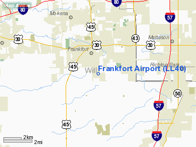
Location
& QuickFacts
|
FAA
Information Effective: |
2007-12-20 |
|
Airport
Identifier: |
LL40 |
|
Airport
Status: |
Operational |
|
Longitude/Latitude: |
087-50-25.7000W/41-28-39.0000N
-87.840472/41.477500 (Estimated) |
|
Elevation: |
778 ft / 237.13 m (Surveyed) |
|
Land: |
73 acres |
|
From
nearest city: |
1 nautical miles SE of Frankfort, IL |
|
Location: |
Will County, IL |
|
Magnetic
Variation: |
02E (1965) |
Owner
& Manager
|
Ownership: |
Privately
owned |
|
Owner: |
Arctic Aviation Inc |
|
Address: |
22763 S. Center Rd
Frankfort, IL 60423 |
|
Phone
number: |
708-878-1100 |
|
Manager: |
Randy W. Strait |
|
Address: |
22763 S. Center Rd
Frankfort, IL 60423 |
|
Phone
number: |
708-878-1100 |
Airport
Operations and Facilities
|
Airport Use: |
Private |
|
Wind
indicator: |
Yes |
|
Segmented
Circle: |
No |
|
Control
Tower: |
No |
|
Lighting
Schedule: |
DUSK-DAWN |
|
Landing
fee charge: |
Yes |
|
Sectional
chart: |
Chicago |
|
Region: |
AGL - Great Lakes |
|
Traffic
Pattern Alt: |
600 ft |
|
Boundary
ARTCC: |
ZAU - Chicago |
|
Tie-in
FSS: |
IKK - Kankakee |
|
FSS
on Airport: |
No |
|
FSS
Toll Free: |
1-800-WX-BRIEF |
|
Federal
Agreements: |
N |
Airport
Communications
|
Runway Information
Runway 09/27
|
Dimension: |
4203
x 50 ft / 1281.1 x 15.2 m |
|
Surface: |
ASPH, Good Condition |
|
Edge
Lights: |
Non-standard lighting system
NSTD LIRL NOT FAA APPROVED L-800 SERIES; NSTD SPACING & INTENSITY.
LIRL
OTS INDEFLY. |
|
|
Runway 09 |
Runway 27 |
|
Longitude: |
087-50-53.3650W |
087-49-58.1480W |
|
Latitude: |
41-28-39.0580N |
41-28-38.9670N |
|
Elevation: |
778.00 ft |
764.00 ft |
|
Alignment: |
90 |
127 |
|
Traffic
Pattern: |
Left |
Left |
|
Markings: |
Non-precision instrument, Good Condition
NSTD DSPLCD THLD MARKINGS FOR RY 27, MKD WITH L 'L' SHAPED
PLASTIC SHEETS HELD DOWN WITH SANDBAGS. |
Non-precision instrument, Good Condition |
|
Displaced
threshold: |
200.00 ft |
627.00 ft |
|
Runway
End Identifier: |
No |
Yes
REIL OTS INDEFLY. |
|
Centerline
Lights: |
No |
No |
|
Touchdown
Lights: |
No |
No |
|
Obstruction: |
123 ft tower, 2662.0 ft from runway, 394 ft
left of centerline, 20:1 slope to clear
APCH RATIO 23:1 TO DSPLCD THLD.
N/S ROAD 13 FT FM DSPLCD THLD 18:, 22 FT BLDG 162 FT SOUTH
OF CNTRLN IN PRIM SFC; 34 FT POLE 35 FT FM RY END & 242
FT RIGHT OF CNTRLN; 14 FT BLDG 88 FT EAST OF RY END. |
61 ft trees, 593.0 ft from runway, 154 ft left
of centerline, 6:1 slope to clear
APCH SLOPE TO DSPLCD THLD IS 20:1. |
|
Radio Navigation
Aids
|
ID |
Type |
Name |
Ch |
Freq |
Var |
Dist |
|
HK |
NDB |
Ermin |
|
332.00 |
01W |
14.5 nm |
|
MX |
NDB |
Kedzi |
|
248.00 |
01W |
17.3 nm |
|
ME |
NDB |
Deana |
|
350.00 |
00E |
30.6 nm |
|
VP |
NDB |
Sedly |
|
212.00 |
02W |
43.4 nm |
|
RZL |
NDB |
Rensselaer |
|
362.00 |
02W |
43.6 nm |
|
OIX |
NDB |
Ottawa |
|
266.00 |
01E |
46.2 nm |
|
DKB |
NDB |
Dekalb |
|
209.00 |
02W |
47.6 nm |
|
MGC |
NDB |
Michigan City |
|
203.00 |
01W |
48.1 nm |
|
IUL |
NDB |
La Porte |
|
356.00 |
03W |
48.1 nm |
|
IKK |
VOR/DME |
Kankakee |
053X |
111.60 |
00E |
24.2 nm |
|
ORD |
VOR/DME |
Chicago O'hare |
086X |
113.90 |
02E |
30.8 nm |
|
DPA |
VOR/DME |
Dupage |
021X |
108.40 |
02E |
33.8 nm |
|
OBK |
VOR/DME |
Northbrook |
077X |
113.00 |
02W |
45.0 nm |
|
CGT |
VORTAC |
Chicago Heights |
089X |
114.20 |
02E |
12.3 nm |
|
EON |
VORTAC |
Peotone |
079X |
113.20 |
02E |
12.7 nm |
|
JOT |
VORTAC |
Joliet |
070X |
112.30 |
02E |
21.9 nm |
|
MDW |
VOT |
Chicago Midway |
|
111.00 |
|
19.0 nm |
|
ORD |
VOT |
Chicago O'hare Intl |
|
112.00 |
|
30.5 nm |
Remarks
- TRMSN
LINE HAS OBSTN LGTS & DAY MKRS.
- BE
ALERT: ALL TWYS UNDER CONSTRUCTION.
- PPR
FOR TSNT ACFT CALL AMGR 708-532-1100.
Based Aircraft
|
Aircraft
based on field: |
24 |
|
Single
Engine Airplanes: |
23 |
|
Multi
Engine Airplanes: |
1 |
Operational Statistics
Time Period: 1998-01-01 - 1998-12-31
|
Aircraft
Operations: |
61/Day |
|
Air
Taxi: |
13.6% |
|
General
Aviation Local: |
45.5% |
|
General
Aviation Itinerant: |
40.9% |
Frankfort Airport
Address:
Will County, IL
Tel:
708-878-1100
Images
and information placed above are from
http://www.airport-data.com/airport/LL40/
We
thank them for the data!
| General
Info |
| Country |
United
States |
| State |
ILLINOIS
|
| FAA ID |
LL40 |
| Latitude |
41.477501
41° 28' 39.00" N |
| Longitude |
-87.840472
087° 50' 25.70" W |
| Elevation |
778 feet
237 meters |
| Type |
Civil
|
| Magnetic
Variation |
003° W
(01/06) |
| Beacon |
Yes |
| Operating
Agency |
U.S.CIVIL
AIRPORT WHEREIN PERMIT COVERS USE BY TRANSIT MILITARY AIRCRAFT |
| Daylight
Saving Time |
Second
Sunday in March at 0200 to first Sunday in November at 0200 local
time (Exception Arizona and that portion of Indiana in the Eastern
Time Zone) |
We don't guarantee the information is fresh and accurate. The data may
be wrong or outdated.
For more up-to-date information please refer to other sources.
|
|


