 |
|
|
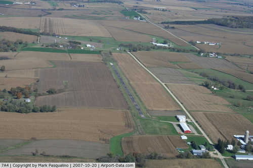 |
(Click on the photo to enlarge) |
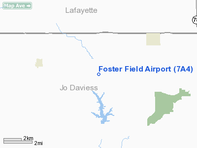
Location
& QuickFacts
|
FAA
Information Effective: |
2007-12-20 |
|
Airport
Identifier: |
7A4 |
|
Airport
Status: |
Operational |
|
Longitude/Latitude: |
090-10-09.8000W/42-27-59.2000N
-90.169389/42.466444 (Estimated) |
|
Elevation: |
990 ft / 301.75 m (Estimated) |
|
Land: |
20 acres |
|
From
nearest city: |
6 nautical miles SW of Apple River, IL |
|
Location: |
Jo Daviess County, IL |
|
Magnetic
Variation: |
01E (1985) |
Owner
& Manager
|
Ownership: |
Privately
owned |
|
Owner: |
Foster Field Llc |
|
Address: |
6144 N. Lake Rd, #1
Apple River, IL 61001 |
|
Phone
number: |
815-541-4282 |
|
Manager: |
Steven H Mcintyre |
|
Address: |
6144 N Lake Rd #1
Apple River, IL 61001 |
|
Phone
number: |
815-492-1118 |
Airport
Operations and Facilities
|
Airport
Use: |
Open
to public |
|
Wind
indicator: |
Yes |
|
Segmented Circle: |
No |
|
Control
Tower: |
No |
|
Lighting
Schedule: |
RDO-CTL
ACTVT MIRL RY 18/36 - CTAF - 7 CLICKS. |
|
Beacon
Color: |
Clear-Green (lighted land airport) |
|
Landing
fee charge: |
Yes |
|
Sectional chart: |
Chicago |
|
Region: |
AGL - Great Lakes |
|
Traffic
Pattern Alt: |
800 ft |
|
Boundary
ARTCC: |
ZAU - Chicago |
|
Tie-in
FSS: |
IKK - Kankakee |
|
FSS
on Airport: |
No |
|
FSS
Toll Free: |
1-800-WX-BRIEF |
|
NOTAMs
Facility: |
IKK (NOTAM-d service avaliable) |
Airport
Communications
|
CTAF: |
122.800 |
|
Unicom: |
122.800
|
|
Runway Information
Runway 18/36
|
Dimension: |
2996
x 30 ft / 913.2 x 9.1 m |
|
Surface: |
ASPH, Fair Condition
20 FT TURF SHOULDERS. |
|
Edge
Lights: |
Non-standard lighting system
NSTD MIRL; NON-FRANGIBLE; SPACING & INTST. |
|
|
Runway 18 |
Runway 36 |
|
Longitude: |
090-10-09.6203W |
090-10-09.9196W |
|
Latitude: |
42-28-13.9509N |
42-27-44.3607N |
|
Elevation: |
982.00 ft |
959.00 ft |
|
Traffic
Pattern: |
Left |
Left |
|
Markings: |
Basic, Good Condition |
Basic, Good Condition |
|
Displaced
threshold: |
187.00 ft
DSPLCD THLDS RYS 18 & 36 NSTD WHITE STRIPE & NRS -
NO ARROWS. |
57.00 ft |
|
Obstruction: |
49 ft tree, 600.0 ft from runway, 80 ft right
of centerline, 8:1 slope to clear
RWY 18 SLOPE IS 16:1 TO DISP THRS .
20 FT+ BRUSH & TREES 80 FT L&R 0 FT ON FENCE LINE. |
26 ft tree, 1043.0 ft from runway, 188 ft right
of centerline, 32:1 slope to clear
RY 36 SLOPE IS 42:1 TO DISP THRS. |
|
Radio Navigation
Aids
|
ID |
Type |
Name |
Ch |
Freq |
Var |
Dist |
|
PVB |
NDB |
Platteville |
|
203.00 |
01E |
17.8 nm |
|
MRJ |
NDB |
Mineral Point |
|
365.00 |
00W |
25.5 nm |
|
FEP |
NDB |
Freeport |
|
335.00 |
00E |
29.1 nm |
|
OQW |
NDB |
Maquoketa |
|
386.00 |
02E |
35.6 nm |
|
CWI |
NDB |
Clinton |
|
377.00 |
01E |
39.0 nm |
|
MXO |
NDB |
Monticello |
|
397.00 |
01E |
45.9 nm |
|
BOZ |
NDB |
Whiteside |
|
254.00 |
01E |
48.5 nm |
|
PLL |
VOR/DME |
Polo |
049X |
111.20 |
03E |
41.6 nm |
|
RFD |
VOR/DME |
Rockford |
045X |
110.80 |
01E |
45.5 nm |
|
JVL |
VOR/DME |
Janesville |
090X |
114.30 |
03E |
47.5 nm |
|
LNR |
VOR/DME |
Lone Rock |
075X |
112.80 |
00E |
49.8 nm |
|
DBQ |
VORTAC |
Dubuque |
105X |
115.80 |
04E |
24.3 nm |
|
CVA |
VORTAC |
Davenport |
085X |
113.80 |
04E |
47.7 nm |
Remarks
- SNOW
REMOVAL UNAVBL. CALL FOR RY COND AT 814-541-4282.
- PRVDD
OBSTN IN RY APCH SLOPE REMOVED/LOWERED OR THR DSPLCD & MKD TO PRVD
MIN 20:1 APCH CLNC OVER OBSTN; AREA 125 FT EITHER SIDE OF RY CL CLEAR
OF OBSTN; APPROP RY SAFETY AREAS PROVDD.
Based Aircraft
|
Aircraft
based on field: |
13 |
|
Single
Engine Airplanes: |
12 |
|
Ultralights: |
1 |
Operational Statistics
Time Period: 2006-01-01 - 2006-12-31
|
Aircraft
Operations: |
39/Week |
|
General
Aviation Local: |
25.0% |
|
General
Aviation Itinerant: |
75.0% |
Foster Field Airport
Address:
Jo Daviess County, IL
Tel:
815-541-4282,
815-492-1118
Images
and information placed above are from
http://www.airport-data.com/airport/7A4/
We
thank them for the data!
| General
Info |
| Country |
United
States |
| State |
ILLINOIS
|
| FAA ID |
7A4 |
| Latitude |
42-27-59.200N
|
| Longitude |
090-10-09.800W
|
| Elevation |
990 feet
|
| Near City |
APPLE
RIVER |
We don't guarantee the information is fresh and accurate. The data may
be wrong or outdated.
For more up-to-date information please refer to other sources.
|
|


